CIVIL WAR NEWSPAPER MAP ARCHIVE
This fine collection was accumulated by the former West Point graduate, American history author, dealer, scholar and sailor
Thomas Truxtun Moebs.
He wrote the catalog descriptions.
Moebs authored:
U.S.
Reference-Iana: (1481-1899) A concise guide to over
4000 books and articles for researching art, books, broadsides, ephemera, manuscripts,
newspapers, maps, pamphlets, photographs and prints relating to that area
within the present limits of the United States 1481-1899. Specifically compiled
for Americana collectors, booksellers and librarians. (1989);
Confederate States Navy Research Guide:
Confederate Naval Imprints Described and Annotated, Chronology of Naval
Operation and Administration, Marine Corps and Naval Officer Biographies,
Description and Service of Vessels, Subject Bibliography (1991);
Black Soldiers, Black Sailors, Black Ink:
Research Guide on African-Americans in U.S. Military History, 1526-1900. (1994);
America's Naval Heritage: A Catalog
of Early Imprints from the Navy Department Library (2000).
-
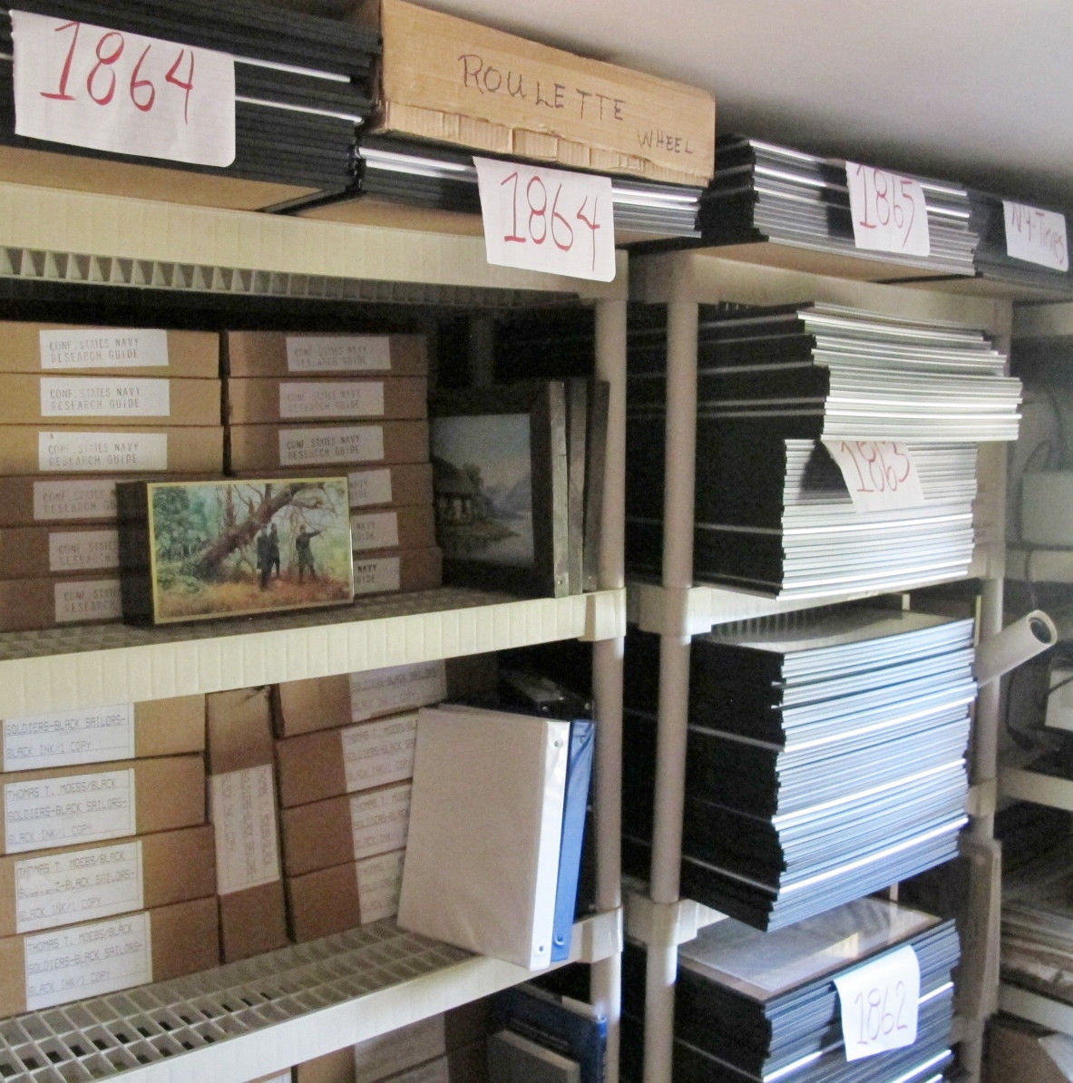
A COLLECTION OF 334 CIVIL WAR NEWSPAPERS
322 OF THESE NEWSPAPERS CONTAIN 380 MAPS (Some papers
have two maps)
299 cataloged issues of The New York Herald. 18
issues of The New York Times. 11 issues of The New York Tribune. 5 issues
of The
Philadelphia Inquirer. 1 issue of the Cincinnati Daily Gazette.
18.5% OF ALL OF THE CIVIL WAR NEWSPAPER MAPS PUBLISHED IN THE
NORTH DURING THE WAR.
HERE IS 49% OF THE CIVIL WAR MAPS PUBLISHED BY THE NEW YORK HERALD.
THE MAPS COVER NEARLY EVERY THEATER OF THE WAR
The nine(9) non-map illustrated papers include: Woodcut Illustration
of a U. S. Treasury Note; Detail Description of the Confederate Army;
Activities of the Pirate Alabama; Description of the Black Valor at Port
Hudson; Description of a Funeral of a Negro Soldier; The
Execution of Mary Surratt (Assassination of Abraham Lincoln); Woodcut
Illustration of the C. S. S. Florida; Detail of the First Black to Speak
Before Congress; & General Hunter Frees Slaves.
EACH NEWSPAPER IS IN VERY GOOD CONDITION &
IN A CLEAR DISPLAY FRAME Here in a single purchase you can
acquire an important Civil War map collection.
Each paper has a full catalog
description.
The American Civil War was the
first war where newspaper maps made a historically significant contribution to
the knowledge of current events.
AVAILABLE
FOR INSPECTION
CONTACT:
JACK
D. HAMILTON
HAMILTON'S
RARE BOOKS
P.
O. 1866
WILLIAMSBURG,
VA 23187
757-220-3000
www.rarebookman.com
CIVIL
WAR NEWSPAPER MAPS
The
New York Herald
1861
May
3, 1861 - The New York
Herald illustrated w/map
“SKETCHED
BY OUR SPECIAL CORRESPONDENT”
[Florida]
[Pensacola Bay] [Map] [1861 – May 3rd] The New
York Herald
(publisher). Pensacola And Its Defences. 19-1/4 x 12-3/4
cm. Engraved map. Removed. Very good. (New York). (Friday,
May 3rd, 1861). - - - “We publish
today an accurate and carefully prepared map sketched by our special
correspondent . . ..” - Publisher. The
map occupies approximately 15 percent of the front page of the May
3rd, 1861 issue (No. 9002) of The
New York Herald. It details the range, fields of fire
and weight of defensive artillery. Complete in eight pages.
Bosse, #629.
June
4, 1861 - The New York Herald illustrated w/map
ONE
OF EARLIEST MAPS
SHOWING
DEEP SOUTH TROOPS ON DOORSTEP TO WASHINGTON
[Virginia]
[“Manassas Gap Junction”] [Map] [1861 – June 4th]
The New York Herald
(publisher). The Seat Of
War. /serrated rule/
The Manassas Gap Junction
And Surroundings - - - The Positions Of The Rebel Troops, Their
Entrenchments, Batteries And Encampments.
20 x 12-3/4 cm. Engraved map. Removed. Two inch break in top
margin without impact on text, but tender. o/w very good. (New
York). (Tuesday, June 4th,
1861). - - - Appearing on the front page of
the June 4th, 1861 issue (No. 9034) of The
New York Herald, this is one of the earliest maps to show
Confederate troops from the deep south deployed before Washington, D.
C. At the top right corner is Washington,
Arlington Heights, Alexandria, and Fairfax Court
House with the Federal Flag flying over McDowell's headquarters.
Most of the remaining map depicts deployment of the Alabama,
Kentucky, North Carolina, South Carolina, and
Virginia troops around Manassas Gap Junction and
in positions protective of the Manassas Gap Railroad
and the Orange and Alexandria Railroad. A fine
Confederate flag designates its operational headquarters to the
southwest of Manassas Gap. Complete in eight pages. Bosse,
#641.
June
9, 1861 - The New York
Herald illustrated w/map
JUNE
9th 1861
FEDERAL
TROOPS DEFENDING NATIONAL CAPITAL
FIRST
SUCH NEWSPAPER MAP
[District
of Columbia] [Defense Of] [Map] [1861] The New York
Herald (publisher).
The Seat Of War. /serrated rule/ Disposition Of The
Federal Troops Near The National Capital. 24-1/4 x 24-3/4 cm.
Engraved map. Removed. Left bound edge irregular from
disbinding but without disturbance to text. o/w very good. (New
York). (Sunday Morning, June 9th, 1861). -
- - This is the first map in Bosse that locates defensive
forces deployed in the District of Columbia. Issue (No. 9039) of The
New York Herald. Complete in eight pages. Bosse,
#643.
June
17, 1861 - The New York Herald illustrated w/map
THE
SEAT OF WAR IN VIRGINIA
[Virginia]
[Military Situation] [Map] [1861 – June 17th]
The New York Herald
(publisher). The Seat Of War In Virginia.
/serrated rule/ Positions Of The Rebel Forces, Batteries,
Intrenchments and Encampments in Virginia - - - The Fortifications
for the Protection of Richmond.
40-1/2 x 33 cm. Engraved map. Removed. Very good. Waters &
Son Engravers. N(ew) Y(ork). (Monday, June 17th,
1861). - - - This
large handsome map locates troop count throughout Virginia; U. S.
flag over Washington, D. C., Confederate flag over Richmond. The map
occupies approximately 75 percent of the front page of the June
17th,
1861 issue (No. 9047) of The
New York Herald.
Textual content includes The Rebellion, State Of Affairs at the Seat
of War, Retreat of
the Rebels from Manassas Junction Towards Richmond,
Skirmish Between the District of Columbia Volunteers and the Rebels
at Leesburg, Movements of the troops Near Washington, Interesting
from Fortress Monroe,
Gen. Butler's Position to be Advanced Several Miles up the Peninsula,
Affairs at the Seat of War in the West, &c. Also includes:
Interesting From The Coast Of Africa, The
Slave Ship Nightingale
. . . Captured by
the United States Ship Saratoga
. . . Landing of
the Negroes and their treatment at Liberia,
&c. Complete in eight pages. Not in Bosse.
July
4, 1861 - The New York Herald illustrated w/map
“STONEWALL”
JACKSON'S FOOT CAVALRY
[Virginia]
[“Potomac River”] [Upper] [Map] [1861 – October 11th]
The New York Herald
(publisher). The Seat Of
War On The Upper Potomac.
/serrated rule/ The
Field Of Battle Tuesday, July 2, 1861 Between General Patterson's
Union Troops And General Jackson's Rebel Forces.
19 x 24-1/2 cm. Engraved map. Removed. Very good. (New
York). (Thursday, July 4th,
1861). - - - “General map of the upper
Potomac River.” - Bosse. The map occupies
approximately 40 percent of the top half of the front page of the
July 4th, 1861 issue (No. 9064) of The
New York Herald. Complete in eight pages. Bosse,
#653.
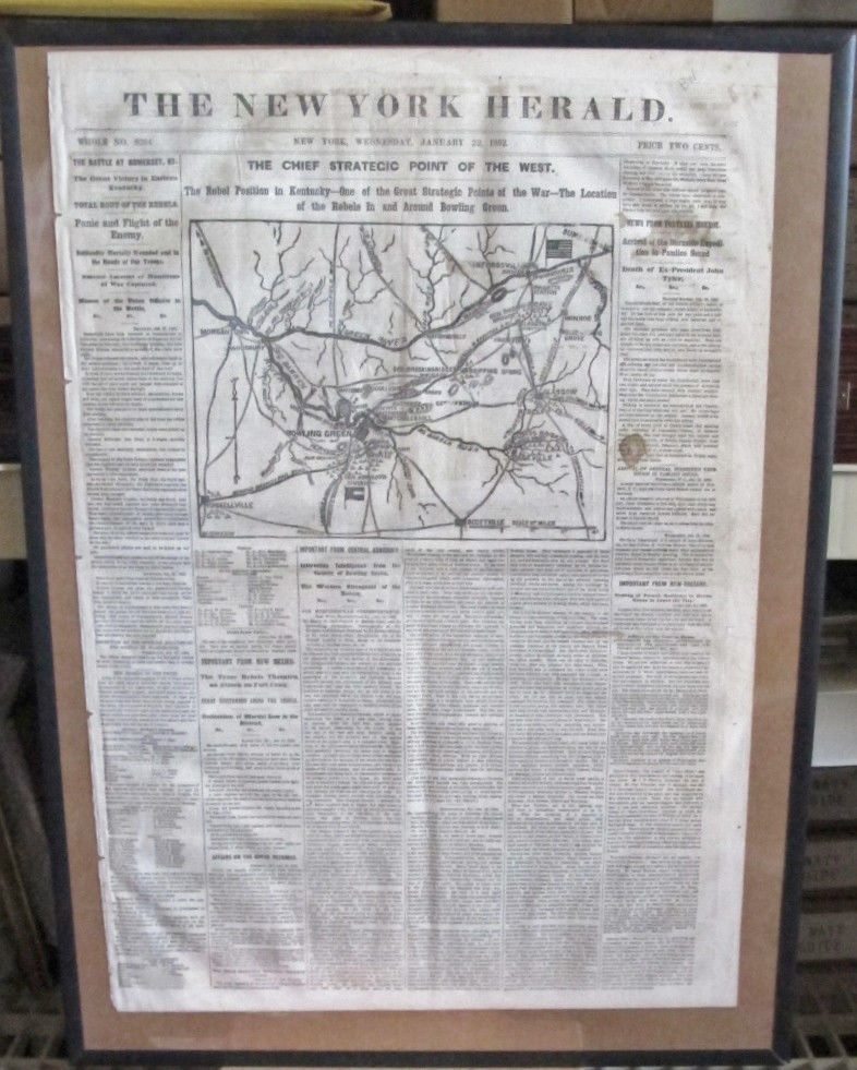
July
8, 1861 - The New York Herald illustrated w/map
MOVEMENTS
OF MISSOURI VOLUNTEERS
[Missouri]
[Military Situation] [Map] [1861 – July 8th]
The New York Herald
(publisher). The Seat Of
War In The West.
/serrated rule/ The
Important Points Of The War In Missouri, Showing The Object Of The
Advance Of Union And Rebel Troops Towards The Southwest.
24-3/4 x 24-1/2 cm. Engraved map. Removed. Very good.
Waters & Son, Eng. N(ew) Y(ork). (Monday, July 8th,
1861). - - - The map occupies 40 percent of
the front page of the July 8th, 1861 issue
(No. 9067) of The New York Herald. Textual
support for the map includes The Movements Of Gen. Lyon And
The Missouri Volunteers. Complete in eight pages.
Bosse, #654. Lynn, #6618.
July
12, 1861 - The New York Herald illustrated w/map
1861
MILITARY SITUATION MAP
[Virginia]
[Military Situation] [Map] [1861 – July 12th]
The New York Herald
(publisher). The Seat Of
War In Virginia.
/serrated rule/ The Positions Of The Union And Rebel Forces In The
Old Dominion. 21-1/2 x 24 cm. Engraved map. Removed. Very good.
(New York). (Friday, July 12th,
1861). - - - The map occupies approximately
50 percent of the front page of the July 12th,
1861 issue (No. 9071) of The New York Herald.
Textual support includes Important News From Western
Virginia, A Brilliant Skirmish At Buchanan and Spirited
Discussion In The House on the State of the Country.
Complete in eight pages. Bosse, #655.
July
28, 1861 - The New York Herald illustrated w/map
“BULL
RUN”
KILLED,
WOUNDED AND MISSING
ALPHABETICAL
LIST BY NAME WITH UNIT
[Virginia]
[“Newport News”] [Map] [1861 – July 28th]
The New York Herald
(publisher). View Of
Newport News. /serrated
rule/ The Intrenchments Of The New York Zouaves, New York Scott Life
Guard, Massachusetts And Vermont Regiments, With The Locations Of The
Outposts, Pickets, &c. 21 x 24-1/2 cm. Engraved map.
Removed. Very good. (New York). (Sunday, July 28th,
1861). - - - 95 percent of the final page is
Casualties At Bull Run, which is an alphabetical
listing by name with unit, of the killed, wounded, and missing.
With a casualty total of 1486, 280 were killed, 729 were wounded, and
477 were missing. The view of Newport News occupies approximately
30 percent of the top half of the front page of this July 28th,
1861 issue (No. 9087) of The New York Herald.
Complete in eight pages. Bosse, #661.
August
12, 1861 - The New York Herald illustrated w/map
CONFEDERATE
TROOPS IN THE WEST
[Arkansas,
Illinois, Missouri and Tennessee]
[Map] [1861 – August 12th]
The New York Herald
(publisher). The Seat
Of War In The West.
/serrated rule/ Map Of
The Scene Of Operations In Southeastern Missouri, Illinois And
Tennessee, With The Positions Of The Rebel Troops And Positions Of
The Federal Forces, And The Defences At Cairo And Bird's Point.
40-1/4 x 24-1/4 cm. Engraved map. Removed. Very good. E. S.
Hall, Del. Waters & Son. (New York). (Monday, August 12th,
1861). - - - “At Cairo, Ill., junction of
the Ohio and Mississippi rivers, the first thirty-two-pound-ball was
fired down the Mississippi as the big guns were planted in position.”
- Long. Occupying approximately 60 percent
of the front page of the August 12th, 1861
issue (No. 9102) of The New York Herald, this
very large map delineates locations of Confederate troops,
railroads, rivers, wetlands and roads.
Complete in eight pages, on page 8 there is a column plus of text
regarding the map. Bosse, #664. E.
B. Long's “The Civil War Day By Day,” p.81 Lynn,
#6727.
August
25, 1861 - The New York Herald illustrated w/map
BATTLE
OF BULL RUN
[Virginia]
[“Battle of Bull Run”] [Map] [1861 – August 25th]
The New York Herald (publisher). Another View Of Bull
Run Battle. /serrated rule/ The Rebel Plan Of The Battle
Field Of Bull Run, Stone Bridge And Manassas Plain. 21-1/2 x
24-1/2 cm. Engraved map. Removed. Very good. (New York).
(Sunday, August 25th, 1861). - - -
Occupying approximately 65 percent of of the top half of the front
page of the August 25th, 1861 issue (No.
9115) of The New York Herald, the map is
supported by text that includes The Battle of Manassas
Plain According To Rebel Authority and Intelligence from
The South, An English Woman's Impressions Of The Rebel
States. Complete in eight pages. Bosse,
#666.
September
12, 1861 - The New York Herald illustrated w/map
OUTSTANDING
1861 MAP
“THE
NATIONAL BATTLEGROUND”
[Virginia]
[Military Situation] [Northern Virginia] [Map] [1861 –
September 12th]
The New York Herald
(publisher). The
National Battleground.
/serrated rule/ The
Armies Of The Potomac - - - Encampments Of Over Three Hundred
Thousand Armed Men - - - Scene Of The Coming Decisive Conflict.
49-3/4 x 35 cm. Engraved map. Removed. Very good. E. S. Hall
del. Waters & Son. N(ew) Y(ork). (Thursday, September 12th,
1861). - - - Constituting the entire front
page of the September 12th, 1861 issue (No.
9133) of The New York Herald, this very large
map “Shows Union and Confederate Positions in northern Virginia.”
- Bosse. Its use of Confederate and Union
flags, text symbols, city layout symbols, etc. marks it as an
outstanding piece of cartography. Complete in eight pages. Bosse,
#670.
September
14, 1861 - The New York Herald illustrated w/woodcut
FAC
SIMILE OF HUNDRED DOLLAR U. S. TREASURY NOTE
[National
Treasury Loan]
[1861 – September 14th]
The New
York Herald
(publisher). The
National Popular Loan.
/serrated rule/ Fac
Simile of a Hundred Dollar Treasury Note, with Coupons Attached - - -
Interesting Financial Intelligence for the People.
10 x 27 cm. Engraved woodcut illustration. Removed. Very
good. (New York). (Saturday, sept 14th,
1861). - - - Supporting text includes The
National Loan,
Operations in the American Bank Note Establishment, Rapid
Manufacture of Treasury Notes,
and Fac Simile Of A Treasury Note &c. Textual reports also
include The Reported Trouble with Major General Fremont, Action
of President Lincoln on Gen. Fremont's Proclamation,
Arrest of
Members of the Maryland Legislature and Other Secessionists,
A Bold Rebel Plot Overthrown by Gen. McClellan, and Another
Skirmish and Rebel Defeat in Western Virginia
&c. Complete in eight pages.
October
6, 1861 - The New York Herald illustrated w/map
SEAT
OF WAR IN KENTUCKY
[Kentucky]
[Confederate Deployments] [Map] [1861 – October 6th]
The New York Herald
(publisher). The Seat
Of War In Kentucky.
16-1/2 x 18-1/2 cm. Engraved map. Removed. Very good. (New
York). (Sunday, October 6th,
1861). - - - Occupying approximately 40
percent of the top half of the front page of the October 6th
issue (No. 9157) of The New York Herald, the map
is supported by text that includes Operations In Kentucky
and Topographical Descriptions of the Field of Operations
in Kentucky. This issue is complete in eight pages.
Bosse, #676. Lynn, #6747.
October
7, 1861 - The New York Herald illustrated w/map
“KANAWHA”
OR WESTERN VIRGINIA
[West
Virginia] [Military Situation]
[Map] [1861 – October 7th]
The New York Herald
(publisher). The Seat Of War In Western Virginia.
/serrated rule/ The Locations Of The Army Of Occupation -
- - Positions Of Generals Rosecrans, Reynolds, Cox, Schenck, Benham,
&c. On The Union Side, And Those Of The Rebel Generals Lee,
Floyd, Anderson, &c. 27 x
23-1/2 cm. Engraved map. Removed. Very good. Waters &
Son. (New York). (Monday, October 7th,
1861). - - -
“”We present our readers this day with a new map of the region
known as Kanawha or Western Virginia. The map has been especially
drawn and engraved for the Herald, and is fuller and contains the
names of a larger number of points . . . than any map or diagram
heretofore issued.” - Publisher.
The map occupies approximately 45 percent of the front page of the
October 7th,
1861 issue (No. 9158) of The
New York Herald.
Complete in eight pages. Bosse,
#677. Lynn,
#6737.
October
8, 1861 - The New York Herald illustrated w/map
STRATEGIC
IMPORTANCE OF POSITIONS
[Kentucky]
[Confederate Deployments] [Map] [1861 – October 8th]
The New York Herald
(publisher). The Seat
Of The War In Kentucky.
/serrated rule/ Locations
Of The Rebel Forces - - - Strategic Importance Of Positions Occupied
By The Opposing Armies.
24 x 36 cm. Engraved map. Removed. Very good. Map by Frank
W. Brooks. Engraved by Waters & Son. (New York). (Tuesday,
October 8th,
1861). - - - Occupying more than half of
the front page of the October 8th, 1861 (No.
9159) of The New York Herald, the map is
supported by text that includes History Of The Invasion Of
That Border State, Efforts Of The Rebels To Drag Kentucky
Out Of The Union, Movements Of The Rebel Troops,
and Positions Occupied By Troops. This issue
is complete in twelve pages. Bosse, #678.
Lynn, #6734.
October
11, 1861 - The New York Herald illustrated w/map
PHOTOGRAPHED
ON WOOD
BAMBERGER'S
CONFEDERATE PRINTED 1861 BATTLE MAP
[Virginia]
[“Battle of Bull Run”] [Map] [1861 – October 11th]
The New York Herald
(publisher). The Curious
Rebel Semi-Official Pictorial View Of The Battle Of Bull Run.
20-1/2 x 23-1/2 cm. Engraved map. Removed. Very good.
Photographed On Wood from The Original Drawing & Engraved By
Waters & Son. N. Y. (Friday, October 11th,
1861). - - - The map cited in the main
entry above is the 1861 Richmond, Virginia printed “Map Of Battles
On Bull Run, Near Manassas, On The Line Of Fairfax And Prince William
Counties, In Virginia, Fought Between The Forces Of The Confederate
States And Of The United States Of America. Gen'ls Beauregard And
Johnston Commanding The Confederate And General McDowell The United
States Forces, On The 21st of July, 1861,
From 7 A. M. To 9 P. M. Made From Observations By Solomon
Bamberger, Published By West & Johnston No. 145 Main Street,
Richmond, Va.” This map, reproduced on the front page of the
October 11th, 1861 issue (No. 9162) of The
New York Herald. The reproduced map occupies
approximately 30 percent of the top half of the front page. The
engraving forces allowed for the inclusion of great detail as well as
extensive notes. Complete in eight pages. Bosse,
#679. Parrish and Willingham, #6148
October
22, 1861 - The New York Herald illustrated w/map
1861
SEAT OF WAR ON THE UPPER POTOMAC
[Virginia]
[“Potomac River”] [Upper] [Map] [1861 – October 22nd]
The
New York Herald
(publisher). The
Seat Of War On The Upper Potomac.
/serrated rule/ The
Field Of Operations Monday, October 21st,
1861 Between General Stone's Union Troops And General Evan's Rebel
Forces.
19 x 24-1/2 cm. Engraved map. Removed. Very good. (New
York). (Thursday, July 4th,
1861). - - -
“Same map published July 4, 1861.” - Bosse.
Complete in twelve pages. Bosse,
#683. Lynn,
#9173.
October
23, 1861 - The New York Herald illustrated w/map
CONFEDERATE
BATTERIES
[Virginia]
[“Potomac River”] [Lower] [Map] [1861 – October 23rd]
The New York Herald
(publisher). Lower
Potomac. /serrated rule/
Map Of The Potomac From
Washington To The Chesapeake, Showing The Rebel Batteries From
Cockpit Point To Mathias Point.
28-1/4 x 31-1/4 cm. Engraved map. Removed. Very good. Waters
- Son. N(ew) Y(ork). (Wednesday, October 23rd,
1861). - - - “From the Federal Navy came
the disquieting news that Confederate batteries commanded all major
points on the Potomac below Alexandria.” - Long.
The map occupies approximately half of the front page of the
October 23rd, 1861 issue (No. 9174) of The
New York Herald and is accompanied by text that includes
New Rebel Batteries at Mathias Point and Six
Miles of Batteries Above the Point. This issue is
complete in eight pages. Bosse, #684. Long,
p. 130. Lynn, #6761.
October
29, 1861 - The New York
Herald illustrated
w/map
COAST
AND LAND LINE of the REBELLIOUS STATES
[Confederate
States of America] [Map]
[1861 – October 29th]
The New York Herald
(publisher). Our Naval
And Military Operations At A Glance.
/serrated rule/ The
Coast and Land Line of the Rebellious States - - - The Union Blockade
of the Atlantic and Gulf Coast - - - Rebel Batteries on the
Mississippi - - - The Forts on the Southern Sea Line.
31-1/2 x 35 cm. Engraved map. Removed. Very good. (New
York). (Tuesday, October 29th,
1861). - - - “Map by Edward S. Hall.,
Engraved by Waters & Son.” - Bosse.
The map occupies approximately 75 percent of the front page of the
October 29th, 1861 issue (No. 9180) of The
New York Herald. Accompanying text includes Our
Account of the Great Armada, A Telling Blow to be Struck
on the Southern Coast, The Embarkation At Annapolis,
Rendezvous at and Departure from Hampton Roads,
Magnitude Of The Expedition, Composition of the Land and
Naval Forces Under Gen. Sherman and Commodore Dupont, War
vessels, Gunboats, Transports, Ferryboats and Surfboats., and Immense
Supplies of War Material, Wagons, Horses, Wheelbarrows, Pick-axes,
Intrenching Implements, Brick, Lumber, Coal and Stores.
Complete in twelve pages. Bosse, #687.
Lynn, #6736
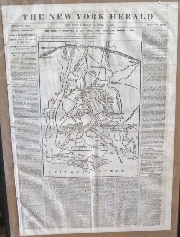
November
9, 1861 - The New York Herald illustrated w/map
DRAWN
BY E. S. HALL
[South
Carolina] [Beaufort]
[Map] [1861 – November 9th]
The New York Herald
(publisher). Map Of
Beaufort, S. C.
/serrated rule/ Scene Of
Operations Of The Great Naval And Military Expedition.
37-1/2 x 23-1/2 cm. Engraved map. Removed. Very good. E. S.
Hall, Del. Waters & Son Sc. (New York). (Saturday, November
9th,
1861). - - - Occupying approximately 60
percent of the front page of the November 9th,
1861 issue (No. 9191) of The New York Herald,
the map is supported by text that includes Arrival Of The
Great Naval And Military Expedition At Port Royal Island,
Opening Bombardment At Beaufort, Commodore Tatnall In
Command Of The Rebels, and Sketch Of Port Royal
And Beaufort. On page eight there is a second map (Map
Of The Scene Of Battle) which measures 17-1/2 by 6-1/2
centimeters and describes the Mississippi River from Hickman to Mound
City, Belmont located at center. Bosse notes of the second map:
“General map of the vicinity of Belmont, Mo.” The map is
supported by text that includes Battle At Belmont,
The Rebels Reinforced From Columbus, Kentucky, and The List
Of Officers Engaged. This issue is complete in eight
pages. Bosse, #690 and #691. Lynn,
#6699.
November
12, 1861 - The New York Herald
illustrated w/map
PROBABLY
FIRST MAP OF CONFEDERATE CAPITAL
[Confederate
States of America] [Capital] [Map] [1861 – November 12th]
The New York Herald (publisher). Map Of The Rebel
Capital. /serrated rule/ Topographical Sketch Of The City Of
Richmond, Virginia, With The Surrounding Encampments. 27 x
34-1/4 cm. Engraved map. Removed. Very good. Waters &
Son. E. S. Hall del. (New York). (Tuesday, November 12th,
1861). - - - The map occupies approximately 50
percent of the front page of the November 12th,
1861 issue (No. 9194) of The New York Herald.
Supporting text includes Public Works, Hotels, Currency,
Shinplasters, Social Life And Manners in the Confederate Capital,
Southern Hatred Against The North, The Questions of Cotton,
Negroes and The Maintenance Of The War and Intrenchments
and Camps of Instruction. Complete in eight
pages. Bosse, #692.
COMPLETE CATALOG UPON REQUEST
|