|
LOOK LIKE NEW USED ONLY @ 2 TIME, I NEED THE MONEY MY LOSS ARE YOU WIN, THANK YOU !!!!!!


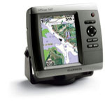
Garmin GPSMAP 540s Combo GPS
Garmin GPSMAP 540s Combo GPS Chartplotter and Fishfinder with Dual Frequency Transom-Mount Transducer - 010-00615-01
With an easier-to-use interface and sleek new design, Garmin GPSMAP 540s packs more value for your navigation dollar.
The Garmin GPSMAP 540s features bright 5" QVGA color display and comes ready to launch right out of the box with built-in cartography, new worldwide satellite imagery, and a new streamlined user interface. The 540-series is preloaded with highly detailed BlueChart® g2™ marine cartography of the coastal United States including Alaska, Hawaii and the Bahamas. The Garmin GPSMAP 540s data provides detailed coastlines, shaded depth contours, navaids, port plans, wrecks, restricted areas and tide and current information.
The powerful built-in analog sounder found in the Garmin GPSMAP 540s can scan as deep as 1500 (in dual frequency mode) and features UltraScroll™ for high-speed screen updates. The Garmin GPSMAP 540s also offers split-screen viewing of map and sounder data for easy, continuous reference.
See real-time weather displayed on the Garmin GPSMAP 540s high-resolution, sunlight readable display with the purchase of the GXM 31 antenna (sold separately) and subscription to XM WX Satellite Weather. View vital weather data such as NEXRAD radar, storm cells, wind speeds, surface temperatures, forecasts and more than a dozen other weather attributes directly on the units chart so you can spend more time enjoying the water and less time worrying about the weather. Plug in optional BlueChart® g2 Vision™ cards into the Garmin GPSMAP 540s to add true 3D-view detailed mapping capabilities (both above and below the waterline), plus helpful auto guidance, high-resolution photomapping detail, and "real picture" aerial photos of ports, harbors, marinas, waterways, navigation landmarks and other points of interest. Product Features and Specifications
Garmin GPSMAP 540s Features:
- Ultra-bright 5" diagonal QVGA display, 320 x 240 pixels 800 nits of brightness
- New streamlined user interface offers easy selection of functions and features
- Preloaded with worldwide satellite imagery and highly detailed BlueChart g2 marine cartography of the coastal United States including Alaska, Hawaii and the Bahamas. This data provides detailed coastlines, shaded depth contours, navaids, port plans, wrecks, restricted areas and tide and current information.
- Preloaded with Explorer charts covering the Bahamas
- View weather overlays such as NEXRAD weather radar and forecasts, current conditions, wind direction, wave direction, wave height, buoy data, lightning, county warnings and much more with the optional GXM 31 antenna
- Single SD memory card slot for BlueChart g2 Vision cards, as well as saving waypoints, routes and tracks to a SD card which can be shared with others
- Built-in GPS antenna
- BNC connector for optional GA29 remote GPS antenna
- Backlit keypad for easier operation at night
- Two NMEA 0183 I/O ports
- CANet™ proprietary bus allows display and control of full feature sounder data on Garmin chartplotters
- Unit dimensions: 6.4" W x 5.9" H x 2.9" D
The Garmin GPSMAP 540s sounder design featuring excellent shallow water performance
- Power output: 500 watts (RMS) 4000 watts (peak to peak), dual frequency 400 watts
- Depth: 1,500 feet (dual frequency)
- Includes a dual frequency transducer 50kHz (40°), 200kHz (10°) for maximum saltwater performance
- Patented transom/trolling mount transducer
- UltraScroll™ high rep rate sonar provides lightning-fast screen updates
- New AutoGain technology enhances target visibility
- See-Thru® technology: shows weak and strong returns simultaneously
- Water temperature log graphically records water temp data
- Round flasher display mode (in dual beam mode) and A-scope (in dual frequency mode)
- Whiteline
- Adjustable depth line helps gauge desired fishing levels and bottom clearance
- Split zoom display offers a closer look at fish targets and bottom structure
- 2X, 4X and bottomlock zoom
- Adjustable keel offset
- Alarms for fish size, shallow water, deep water and low battery
Enable the full functionality of the Garmin GPSMAP 540s with the addition of a BlueChart g2 Vision SD card BlueChart g2 Vision cards provide:
- High-resolution satellite imagery when overlaid on the chart, will provide the mariner with unparalleled situational awareness
- Aerial reference photography provides "real world" photos of ports, harbors, marinas, waterways, navigation landmarks and other points of interest, offering the mariner another powerful tool for navigating unfamiliar waters
- Mariners Eye view Provides the mariner with a 3-D perspective of chart information for a quick, reliable and easy position fix
- Fish Eye view 3D perspective below the water line for displaying bottom contours based on bathymetric charting data
- Auto guidance technology will search the attributes of all relevant charts to suggest the best course for navigation
- Fishing charts, tides, currents, marine services, coastal roads and points of interest detail
|
 Shopping Cart