Click Here. Double your traffic. Get Vendio Gallery - Now FREE!
Coins of India Reference Library
These DVD's are part of our Historic Book
Collection.
We have Thousands of Books, Magazines, Maps and Films on CD and DVD
and DVDs covering many areas and topics.
Please Check our Ebay Store for what's available. |
This is the definitive work on the American
Civil War prepared by the United States Government in the years following
the conflict (1880 to 1922).
These DVDs contains all 95 volumes, all 205
books (some volumes have more than one book), all
164,320 pages as well as well as all 175 maps
and plates in the Official Atlas.
These volumes include correspondence and official reports of dozens
of Union and Confederate generals and other officers, official orders and
reports to and from President Lincoln, names and numbers of causalities,
spies and prisoners and much, much, much more.
These volumes are an invaluable reference work for Civil War historians,
teachers, students, and American history buffs, for home schooling and for
anyone doing genealogy research or doing research on family members
during the Civil War.
It would take many years to read and digest all this
information. |
All Books are in Perfect Page format, which means that
the ebooks looks exactly like the original books with
all formatting of tables, pictures, maps and other details preserved. No
garbled text where a table or picture used to be which is the norm on less
expensive items being sold. There is so much information here that it takes
almost 2 full DVDs (8.27 GIGAbytes in fact).
All books are SEACHABLE and you can
CUT AND PAST text from the books for use in
other documents you may want to create.
The books are in PDF format which allows
you to adjust page size or book layout to suit your own personal reading
needs and style. You can zoom in if you need the page larger. Practically
all computers these days can read PDF files and if not then the FREE reader
is available online.
The DVDs have a very simple HTML interface and table of contents
and are designed for ease of use. The look and feel is very similar to viewing
a webpage.
The DVDs are totally self contained (i.e. all the data is on the
disk themselves) and you do NOT need an Internet
connection to make use of them. |
This HUGE 2 DVD set contains the ENTIRE
Official Records series including the
Army records, the
Atlas that was produced to go with the records,
the Naval records all
supplements issued, a full index to the entire
series and an index of the Battles of
the War. (No index for the Naval volumes was every completed)
1. The War of the Rebellion: A Compilation of the Official Records
of the Union and Confederate Armies
And
2. Atlas to Accompany the Official Records
And
3. Official Records of the Union and Confederate Navies in the
War of the Rebellion
|
The War of the Rebellion: A Compilation of the Official Records
of the Union and Confederate Armies
Series I
Contains the formal reports, both Union and Confederate, of the first
seizures of United States property in the Southern States, and of all military
operations in the field, with the correspondence, orders, and returns relating
specially thereto, and, as proposed is to be accompanied by an Atlas. In
this series the reports will be arranged according to the campaigns and several
theaters of operations (in the chronological order of the events), and the
Union reports of any event will, as a rule, be immediately followed by the
Confederate accounts. The correspondence, etc., not embraced in the "reports"
proper will follow (first Union and next Confederate) in chronological
order.
SERIES I-VOLUME I (691 pages)
Chapter I - Operations in Charleston Harbor, South Carolina. Dec. 20,
1860-Apr. 4, 1861
Chapter II - The secession of Georgia. Jan. 3-26, 1861.
Chapter III - The secession of Alabama and Mississippi. Jan. 4-20, 1861.
Chapter IV - Operations in Florida. Jan. 6-Aug. 31, 1861.
Chapter V - The secession of North Carolina. Jan. 9-May 20, 1861.
Chapter VI - The secession of Louisiana. Jan. 10-Feb. 19, 1861.
Chapter VII - Operations in Texas and New Mexico. Feb. 1-Jun 11, 1861.
Chapter VIII - Operations in Arkansas, the Indian Territory, and Missouri.
Feb. 7-May 9, 1861.
SERIES I VOLUME II (1012 pages)
Chapter IX - Operations in Maryland, Pennsylvania, Virginia, and West
Virginia. Apr 16-Jul 31, 1861.
SERIES I - VOLUME III (830 pages)
Chapter X - Operations in Missouri, Arkansas, Kansas and Indian Territory.
May 10-Nov. 19, 1861.
SERIES I-VOLUME IV (800 pages)
Chapter XI - Operations in Texas, New Mexico, and Arizona. Jun 11,
1861-Feb. 1, 1862.
Chapter XII - Operations in Kentucky and Tennessee. Jul 1-Nov. 19,
1861.
Chapter XIII - Operations in North Carolina and Southeastern Virginia.
Aug. 1, 1861-Jan. 11, 1862.
SERIES I-VOLUME V (1220 pages)
Chapter XIV - Operations in Maryland, Northern Virginia, and West
Virginia. Aug. 1, 1861-Mar 17, 1862.
SERIES I-VOLUME VI (984 pages)
Chapter XV - Operations on the coasts of South Carolina, Georgia,
and Middle and East Florida. Aug 21, 1861-Apr 11, 1862.
Chapter XVI - Operations in West Florida, Southern alabama, Southern
Mississippi, and Louisiana. Sep 1, 1861-May 12, 1862.
SERIES I-VOLUME VII (1038 pages)
Chapter XVII - Operations in Kentucky, Tennessee, N. Alabama, and
W. Virginia. Nov. 19, 1861-Mar 4, 1862.
SERIES I - VOLUME VIII (922 pages)
Chapter XVIII - Operations in Missouri, Arkansas, Kansas, and Indian
Territory. Nov. 19, 1861-Apr 10, 1862.
SERIES I- VOLUME IX (814 pages)
Chapter XIX - Operations in Southeastern Virginia. Jan. 11-Mar 17,
1862.
Chapter XX - Operations in North Carolina. Jan. 11-Aug. 20,
1862.
Chapter XXI - Operations in Texas, New Mexico, and Arizona. Feb.
1-Sep. 20, 1862.
SERIES I-VOLUME X IN TWO PARTS (1046 pages and 704 pages)
Chapter XXII - Operations in Kentucky, Tennessee, North Mississippi,
North Alabama, and Southwest Virginia. Mar 4-Jun 10, 1863.
SERIES I VOLUME XI IN THREE PARTS (1188 pages, 1100 pages
and 754 pages)
Chapter XXIII - The Peninsular Campaign, Virginia. Mar 17-Sep. 2,
1862.
SERIES I - VOLUME XII - IN THREE PARTS (900 pages, 1238
pages, and 1038 pages)
Chapter XXIV - Operations in Missouri, Arkansas, Kansas, the Indian
Territory, and the Department of the Northwest. Nov. 20, 1862-Dec. 31,
1863.
SERIES I-VOLUME XIII (1104 pages)
Chapter XXV -- Operations in Missouri, Arkansas, Kansas, the Indian
Territory, and the Department of the Northwest. Apr. 10-Nov. 20,
1862.
SERIES I-VOLUME XIV (1134 pages)
Chapter XXVI - Operations on the coasts of South Carolina, Georgia,
and Middle and East Florida. Apr 12, 1862-Jun 11, 1863
SERIES I-VOLUME XV (1280 pages)
Chapter XXVII - Operations in West Florida, Southern Alabama, Southern
Mississippi (embracing all operations against Vicksburg, May 18-Jul 27, 1862);
and Louisiana, May 12, 1862-May 14, 1863; and operations in Texas, New Mexico,
and Arizona, Sep 20,1862-May 14, 1863.
SERIES I-VOLUME XVI IN TWO PARTS (1256 pages, and 1114
pages)
Chapter XXVIII - Operations in Kentucky, Middle and East Tennessee,
North Alabama, and Southwest Virginia. Jun 10-Oct 31, 1862.
SERIES I - VOLUME XXVII IN TWO PARTS (914 pages and
1024 pages)
Chapter XXIX - Operations in West Tennessee and Northern Mississippi.
Jun 10, 1862-Jan 20, 1863.
SERIES I-VOLUME XVIII (1224 pages)
Chapter XXX - Operations in North Carolina and Southeastern Virginia.
Aug 29, 1862-Jun 3, 1863.
SERIES I-VOLUME XIX -IN TWO PARTS (1232 pages and 824 pages)
Chapter XXXI - Operations in Northern Virginia, West Virginia, Maryland,
and Pennsylvania. Sep 3-Nov 14, 1862.
SERIES I VOLUME XX IN TWO PARTS (1132 pages, and 584 pages)
Chapter XXXII - Operations in Kentucky, Middle and East Tennessee,
North Alabama, and Southwest Virginia. Nov. 1, 1862-Jan. 20, 1863.
SERIES I VOLUME XXI (1296 pages)
Chapter XXXIII - Operations in Northern Virginia, West Virginia,
Maryland, and Pennsylvania. November 15, 1862 - January 25, 1863.
SERIES I - VOLUME XXII (1050 pages and 1268 pages)
Chapter XXXIV - Operations in Missouri, Arkansas, Kansas, the Indian
Territory, and the Department of the Northwest. Nov. 20, 1862-Dec. 31,
1863.
SERIES I-VOLUME XXIII-IN TWO PARTS (978 pages and 1092
pages)
Chapter XXXV - Operations in Kentucky, Middle and East Tennessee,
North Alabama, and Southwest Virginia. January 21 - August 10,
1863.
SERIES 1 -VOLUME XXIV - in Three Parts. (892 pages, 796
pages, and 1198 pages)
Chapter XXXVI - Operations in Mississippi and West Tennessee, including
those in Arkansas and Louisiana connected with the Siege of Vicksburg. January
20 - August 10, 1863.
SERIES I-VOLUME XXV-IN TWO PARTS (1286 pages, and 978 pages)
Chapter XXXVII - Operations in Northern Virginia, West Virginia,
Maryland, and Pennsylvania. January 26-June 3, 1863.
SERIES I-VOLUME XXVI-IN TWO PARTS (1058 pages, and 638
pages)
Chapter XXXVIII - Operations in West Florida, Southern Alabama, Southern
Mississippi, Louisiana, Texas, and New Mexico. May 14-December 31,
1863
SERIES I - VOLUME XXVII - IN THREE PARTS (1184 pages, 1120
pages, 1244 pages)
Chapter XXXIX - Operations in North Carolina, Virginia, West Virginia,
Maryland, Pennsylvania, and Department of the East. June 3-August 3,
1863.
SERIES 1-VOLUME XXVIII-IN TWO PARTS (828 pages, and 674
pages)
Chapter XL - Operations on the coasts of South Carolina and Georgia,
an din Middle and East Florida. June 12-December 31, 1863.
SERIES I-VOLUME XXIX-IN TWO PARTS (1172 pages, and 1076
pages)
Chapter XLI - Operations in North Carolina, Virginia, West Virginia,
Maryland, and Pennsylvania. August 4-December 31, 1863.
SERIES I-VOLUME XXX-IN FOUR PARTS (1194 pages, 946 pages,
1120 pages, and 862 pages)
Chapter XLII - Operations in Kentucky, Southwest Virginia, Tennessee,
Mississippi, North Alabama, and North Georgia. August 11-October 19,
1863.
SERIES I VOLUME XXXI IN THREE PARTS (984 pages, 870 pages,
1032 pages)
Chapter XLIII - Operations in Kentucky, Southwest Virginia, Tennessee,
Mississippi, North Alabama, and North Georgia. October 20-December 31,
1863.
SERIES I-VOLUME XXXII-IN THREE PARTS (862 pages, 970 pages,
and 1020 pages)
Chapter XLIV - Operations in Kentucky, Southwest Virginia, Tennessee,
Mississippi, Alabama, and North Georgia. January 1-April 30, 1864.
SERIES I-VOLUME XXXIII (1544 pages)
Chapter XLV - Operations in North Carolina, Virginia, West Virginia,
Maryland, and Pennsylvania. January 1-April 30, 1864.
SERIES I-VOLUME XXXIV IN FOUR PARTS (1208 pages, 1238 pages,
930 pages, 810 pages)
Chapter XLVI - Operations in Louisiana and the Trans-Mississippi
States and Territories. January 1-June 30, 1864.
SERIES I - VOLUME XXXV -IN TWO PARTS (738 pages, and 722
pages)
Chapter XLVII - Operations in South Carolina and Florida, and on
the Georgia Coast. January 1-November 13, 1864.
SERIES I - VOLUME XXXVI - IN THREE PARTS (1242 pages, 1130
pages, and 988 pages)
Chapter XLVIII - Operations in Southeastern Virginia and North Carolina.
May 1-June 12, 1864.
SERIES I - VOLUME XXXVII - IN TWO PARTS (890 pages, 684
pages)
Chapter XLIX - Operations in Northern West Virginia, Maryland, and
Pennsylvania. May 1-August 3, 1864.
SERIES I-VOLUME XXXVIII- IN 5 PARTS (1048 pages, 1000 pages,
1112 pages, 874 pages, and 1110 pages)
Chapter L - The Atlanta, Ga., Campaign. May 1-September 8,
1864
SERIES I-VOLUME XXXIX-IN THREE PARTS (1050 pages, 1048
pages, 1034 pages)
Chapter LI - Operations in Kentucky, Southwest Virginia, Tennessee,
Mississippi, Alabama, and North Georgia (the Atlanta Campaign excepted).
May 1-November 13, 1864.
Chapter LIV - Operations in Southeastern Virginia and North Carolina.
August 1-December 31, 1864.
SERIES I VOLUME XL IN THREE PARTS (924 pages, 798 pages,
908 pages)
Chapter XXIV - Operations in Northern Virginia, West Virginia, and
Maryland. Mar 17-Sep 2, 1862.
SERIES I-VOLUME XLI-IN FOUR PARTS (1162 pages, 1240 pages,
1130 pages, and 1312 pages)
Chapter LIII - Operations in Louisiana and the Trans-Mississippi
States and Territories. July 1-December 31, 1864.
SERIES I - VOLUME XLII - IN THREE PARTS (1148 pages, 1438
pages, and 1534 pages)
Chapter LIV - Operations in Southeastern Virginia and North Carolina.
August 1-December 31, 1864.
SERIES I-VOLUME XLIII-IN TWO PARTS (1168 pages, and 1070
pages)
Chapter LV - Operations in Northern Virginia, West Virginia, Maryland,
and Pennsylvania. August 4-December 31, 1864.
SERIES I - VOLUME XLIV (1128 pages)
Chapter LVI - Operations in South Carolina, Georgia, and Florida.
November 14-December 31, 1864.
SERIES I-VOLUME XLV IN TWO PARTS (1434 pages, and 906 pages)
Chapter LVII - Operations in Kentucky, Southwest Virginia, Tennessee,
Mississippi, Alabama, and North Georgia. November 14, 1864-January 22,
1865.
SERIES I - VOLUME XLVI - IN THREE PARTS (1518 pages, 1496
pages, and 1552 pages)
Chapter LVIII - Operations in Northern and Southeastern Virginia,
North Carolina (January 1-31), West Virginia, Maryland, and Pennsylvania.
January 1-June 30, 1865.
SERIES I--VOLUME XLVII--IN THREE PARTS (1258 pages, 1590
pages, and 976 pages)
Chapter LIX - Operations in North Carolina (from February 1), South
Carolina, Southern Georgia, and East Florida. January 1-June 30,
1865.
SERIES I--VOLUME XLVIII--IN TWO PARTS (1680 pages, and
1484 pages)
Chapter LX - Operations in Louisiana and the Trans-Mississippi States
and Territories. January 1-June 30, 1865.
SERIES I-VOLUME XLIX-IN TWO PARTS (1242 pages, and 1442
pages)
Chapter LXI - Operations in Kentucky, Southwestern Virginia, Tennessee,
Northern and Central Georgia, Mississippi, Alabama, and West Florida. January
1-June 30, 1865.
SERIES I-VOLUME L-IN TWO PARTS (1296 pages, and 1392 pages)
Chapter LXII - Operations on the Pacific Coast
SERIES I - VOLUME LI IN TWO PARTS (1480 pages and 1218)
LII and LIII (additional supplement volumes) are included in the
volume above as one document for ease of searching the supplements.
Chapter LXIII - Operations in Maryland, Eastern North Carolina,
Pennsylvania, Virginia (except Southwestern), and West Virginia. January
1, 1861-June 30, 1865.
SUPPLEMENT Embracing Documents Found or Received Too Late for Insertion
in Volumes 1, 2, 4, 5, 9, 11, 12, 18, 19, 21, 25, 27, 29, 33, 36, 37, 40,
42, 43, and 46. [Note: The number in brackets at the lower left hand of each
document indicates the volume to which it properly belongs.]
Volume LII - in Two Parts. 1898. (Vol. 52, Chap. 64) SUPPLEMENT
(included in volume above) (870 pages and 930 pages)
Chapter LXIV - Operations in Southwestern Virginia, Kentucky, Tennessee,
Mississippi, Alabama, West Florida, and Northern Georgia. January 1, 1861-June
30, 1865.
SUPPLEMENT Embracing Documents Found or Received Too Late for Insertion
in Volumes 1, 4, 6, 7, 10, 15, 16, 17, 20, 23, 24, 26, 30, 31, 32, 38, 39,
45, and 49. [Note: The number in brackets at the lower left hand of each
document indicates the volume to which it properly belongs.]
Part I - Reports, Union Correspondence, etc.
Part II - Confederate Correspondence, etc.
Volume LIII. 1898. (Vol. 53, Chap. 65) SUPPLEMENT
(included in volume above) (1208 pages)
Chapter LXV - Operations in South Carolina, Southern Georgia, Middle
and East Florida, and Western North Carolina. January 1, 1861-June 30,
1865.
SUPPLEMENT Embracing Documents Found or Received Too Late for Insertion
in Volumes 1, 6, 14, 28, 35, 44, and 47. [Note: The number in brackets at
the lower left hand of each document indicates the volume to which it properly
belongs.]
Reports and Correspondence.
SERIES I - VOLUME XLIV (1128 pages)
Chapter LVI - Operations in South Carolina, Georgia, and Florida.
November 14-December 31, 1864.
SERIES I-VOLUME XLV IN TWO PARTS (1434 pages, and 906
pages)
Chapter LVII - Operations in Kentucky, Southwest Virginia, Tennessee,
Mississippi, Alabama, and North Georgia. November 14, 1864-January 22,
1865.
SERIES I - VOLUME XLVI - IN THREE PARTS (1518 pages, 1496
pages, and 1552 pages)
Chapter LVIII - Operations in Northern and Southeastern Virginia,
North Carolina (January 1-31), West Virginia, Maryland, and Pennsylvania.
January 1-June 30, 1865.
SERIES I--VOLUME XLVII--IN THREE PARTS (1258 pages, 1590
pages, and 976 pages)
Chapter LIX - Operations in North Carolina (from February 1), South
Carolina, Southern Georgia, and East Florida. January 1-June 30,
1865.
SERIES I--VOLUME XLVIII--IN TWO PARTS (1680 pages, and
1484 pages)
Chapter LX - Operations in Louisiana and the Trans-Mississippi States
and Territories. January 1-June 30, 1865.
SERIES I-VOLUME XLIX-IN TWO PARTS (1242 pages, and 1442
pages)
Chapter LXI - Operations in Kentucky, Southwestern Virginia, Tennessee,
Northern and Central Georgia, Mississippi, Alabama, and West Florida. January
1-June 30, 1865.
SERIES I-VOLUME L-IN TWO PARTS (1296 pages, and 1392 pages)
Chapter LXII - Operations on the Pacific Coast
SERIES I - VOLUME LI IN TWO PARTS (1480 pages and 1218)
LII and LIII (additional supplement volumes) are included in the
volume above as one document for ease of searching the supplements.
Chapter LXIII - Operations in Maryland, Eastern North Carolina,
Pennsylvania, Virginia (except Southwestern), and West Virginia. January
1, 1861-June 30, 1865.
SUPPLEMENT Embracing Documents Found or Received Too Late for Insertion
in Volumes 1, 2, 4, 5, 9, 11, 12, 18, 19, 21, 25, 27, 29, 33, 36, 37, 40,
42, 43, and 46. [Note: The number in brackets at the lower left hand of each
document indicates the volume to which it properly belongs.]
Volume LII - in Two Parts. 1898. (Vol. 52, Chap. 64) SUPPLEMENT
(included in volume above) (870 pages and 930 pages)
Chapter LXIV - Operations in Southwestern Virginia, Kentucky, Tennessee,
Mississippi, Alabama, West Florida, and Northern Georgia. January 1, 1861-June
30, 1865.
SUPPLEMENT Embracing Documents Found or Received Too Late for Insertion
in Volumes 1, 4, 6, 7, 10, 15, 16, 17, 20, 23, 24, 26, 30, 31, 32, 38, 39,
45, and 49. [Note: The number in brackets at the lower left hand of each
document indicates the volume to which it properly belongs.]
Part I - Reports, Union Correspondence, etc.
Part II - Confederate Correspondence, etc.
Volume LIII. 1898. (Vol. 53, Chap. 65) SUPPLEMENT
(included in volume above) (1208 pages)
Chapter LXV - Operations in South Carolina, Southern Georgia, Middle
and East Florida, and Western North Carolina. January 1, 1861-June 30,
1865.
SUPPLEMENT Embracing Documents Found or Received Too Late for Insertion
in Volumes 1, 6, 14, 28, 35, 44, and 47. [Note: The number in brackets at
the lower left hand of each document indicates the volume to which it properly
belongs.]
Reports and Correspondence.
Series II
Contains the correspondence, orders, reports, and returns, Union
and Confederate, relating to prisoners of war, and (so far as the military
authorities were concerned) to State or political prisoners.
SERIES II - VOLUME I.
Volume I. 1894 (1058 pages)
1. The Texas Surrender
2. Earlier Captures and Arrests, and Measures of Pacification in
Missouri
3. Union Policy of Repression in Maryland
4. Military Treatment of Captured and Fugitive Slaves
5. Confederate Policy of Repression in East Tennessee
Volume II. 1897 (1644 pages)
Treatment of suspected and disloyal persons, North and South.
Volume III. 1898 (1028 pages)
Correspondence, Orders, etc., relating to Prisoners of War and State
from February 19, 1861, to June 12, 1862.
Volume IV. 1899 (1028 pages)
Correspondence, Orders, etc., from June 13, 1862, to November 30,
1862.
Volume V. 1899 (1038 pages)
Correspondence, Orders, etc., from December 1, 1862, to June 10,
1863.
Volume VI. 1899 (1196 pages)
Correspondence, Orders, etc., from June 11, 1863, to March 31, 1864.
Volume VII. 1899 (1380 pages)
Correspondence, Orders, etc., from April 1, 1864, to December 31,
1864.
Volume VIII. 1899 (1072 pages)
Correspondence, Orders, etc., from January 1, 1865, to the end.
SERIES III
Series III: Contains the correspondence, orders, reports, and returns
of the Union authorities (embracing their correspondence with the Confederate
officials) not relating specially to the subjects of the first and second
series. It will set forth the annual and special reports of the Secretary
of War, of the General-in-Chief, and of the chiefs of the several staff corps
and departments; the calls for troops, and the correspondence between the
national and the several State authorities.
Volume I. 1899 (1028 pages)
Correspondence, Orders, etc., from November 1, 1860, to March 31,
1862.
Volume II. 1899 (1020 pages)
Correspondence, Orders, etc., from April 1, 1862, to December 31,
1862.
Volume III. 1899 (1266 pages)
Correspondence, Orders, etc., from January 1, 1863, to December
31, 1863.
Volume IV. 1900 (1362 pages)
Correspondence, Orders, etc., from January 1, 1864, to April 30,
1865.
Volume V. 1900 (1118 pages)
Correspondence, Orders, etc., from May 1, 1865, to the end.
SERIES IV
Contains the correspondence, orders, reports, and returns of the
Confederate authorities, similar to that indicated for the Union officials,
as of the third series, but excluding the correspondence between the Union
and Confederate authorities given in that series.
Volume I. 1900 (1246 pages)
Correspondence, Orders, etc., from December 20, 1860, to June 30,
1862.
Volume II. 1900 (1144 pages)
Correspondence, Orders, etc., from July 1, 1862, to December 31,
1863.
Volume III. 1900 (1258 pages)
Correspondence, Orders, etc., from January 1, 1864, to the end.
Volume IV. 1900 (1304 pages)
Explanations.
Synopsis of the contents of volumes.
Special Index for the principal armies, army corps, military divisions
and departments.
Table showing volumes pertaining to contemporaneous
operations.
General Index.
Additions and Corrections.
Indexes and Report
Index-1 "A" through Marye,
Morton
Index-2
Marye, R. B., through
"Z"
Index to the Battles
Report to the Board
Official Records of the Union and Confederate Navies
in the War of the Rebellion
Series I
VOLUME 1: The Operation of the Cruisers (January 19, 1861 - January
4, 1863). 1894.
VOLUME 2: The Operation of the Cruisers (January 1, 1863 - March
31, 1864). 1895.
VOLUME 3: The Operation of the Cruisers (April 1, 1864 - December
30, 1865). 1896.
VOLUME 4: Operations in the Gulf of Mexico (November 15, 1860 -
June 7, 1861); Operations on the Atlantic Coast (January 1, 1861 - May 13,
1861); Operations on the Potomac and Rappahannock Rivers (January 5, 1861..
1896.
VOLUME 5: Operations on the Potamac and Rappahannock Rivers (December
7, 1861 - July 31, 1865); Atlantic Blockading Squadron (April 4, 1861 - July
15, 1861). 1897.
VOLUME 6: Atlantic Blockading Squadron (July 16, 1861 - October
29, 1861); North Atlantic Blockading Squadron (October 29, 1861 - March 8,
1862). 1897.
VOLUME 7: North Atlantic Blockading Squadron (March 8, 1862 - September
4, 1862). 1898.
VOLUME 8: North Atlantic Blockading Squadron (September 5, 1862
- May 4, 1863). 1899.
VOLUME 9: North Atlantic Blockading Squadron (May 5, 1863 - May
5, 1864). 1899.
VOLUME 10: North Atlantic Blockading Squadron (May 6, 1864 - October
27, 1864). 1900.
VOLUME 11: North Atlantic Blockading Squadron (October 28, 1864
- February 1, 1865). 1900.
VOLUME 12: North Atlantic Blockading Squadron (February 2, 1865
- August 3, 1865); South Atlantic Blockading Squadron (October 29, 1861 -
May 13, 1862). 1901.
VOLUME 13: South Atlantic Blockading Squadron (May 14, 1862 - April
7, 1863). 1901.
VOLUME 14: South Atlantic Blockading Squadron (April 7, 1863 - September
30, 1863). 1902.
VOLUME 15: South Atlantic Blockading Squadron (October 1, 1863 -
September 30, 1864). 1902.
VOLUME 16: South Atlantic Blockading Squadron (October 1, 1864 -
September 30, 1865); Gulf Blockading Squadron (June 7, 1861 - December 15,
1861). 1903.
VOLUME 17: Gulf Blockading Squadron (December 16, 1861 - February
21, 1862); East Gulf Blockading Squadron (December 22, 1862 - July 17, 1865).
1903.
VOLUME 18: West Gulf Blockading Squadron (February 21, 1862 - July
14, 1862). 1904.
VOLUME 19: West Gulf Blockading Squadron (July 15, 1862 - March
14, 1863). 1905.
VOLUME 20: West Gulf Blockading Squadron (March 15, 1863 - December
31, 1863). 1905.
VOLUME 21: West Gulf Blockading Squadron (January 1, 1864 - December
31, 1864). 1906.
VOLUME 22: West Gulf Blockading Squadron (January 1, 1865 - January
31, 1866); Naval Forces on Western Waters (May 8, 1861 - April 11, 1862).
1908.
VOLUME 23: Naval Forces on Western Waters (April 12, 1862 - December
31, 1862). 1910.
VOLUME 24: Naval Forces on Western Waters (January 1, 1863 - May
17, 1863). 1911.
VOLUME 25: Naval Forces on Western Waters (May 18, 1863 - February
29, 1864). 1912.
VOLUME 26: Naval Forces on Western Waters (March 1, 1864 - December
31, 1864). 1914.
VOLUME 27: Naval Forces on Western Waters (January 1, 1865 - September
6, 1865); Supply Vessels (January 1, 1865 - September 6, 1865). 1917.
Series II
VOLUME 1: Statistical Data of Union and Confederate Ships; Muster
Roles of Confederate Government Vessels; Letters of Marque and Reprisals;
Confederate Department Investigations. 1921.
VOLUME 2: Navy Department Correspondence 1861-1865, with Agents
Abroad. 1921.
VOLUME 3: Proclamations, Appointments, etc. of President Davis;
State Department Correspondence with Diplomatic Agents,etc.. 1922. |
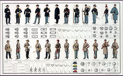
The Atlas to Accompany
the Official Records of the
Union and Confederate
Armies
Published under the direction of the Hons. Redfield Proctor,
Stephen B. Elkins and Daniel S. Lamont, secretaries of war, by Maj. George
B. Davis, U.S. Army, Mr. Leslie J. Perry, civilian expert, Mr. Joseph W.
Kirkley, civilian expert, Board of Publication. Compiled by Capt. Calvin
D. Cowles, 23d U.S. Infantry. Washington: Government Printing Office,
1891-1895.
The Atlas to accompany the official records of the Union and Confederate
armies is THE definative work on the Ameican Civil War when it comes to maps.
Initially issued in 37 parts between 1891 and 1895, it includes 178 plates
and constitutes the most detailed atlas ever published on the Civil War.
The maps present an especially well-balanced cartographic record of
the war because both Union and Confederate sources were used in their
compilation.
Confederate topographic engineer Jedediah Hotchkiss, for example, supplied
the editors with 123 maps for this atlas.
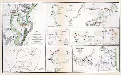
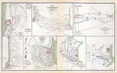
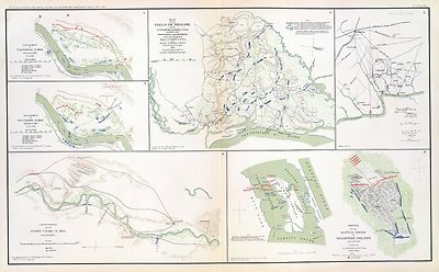
Just a few of the many maps and plates on this
disk

Plate 001
|
Fort Moultrie as seen from Fort Sumter, February 13th, 1861. T. Seymour,
Brevet Capt. U.S.A. Fort Johnson as seen from Fort Sumter ... Morris Island
and Cumming's Point as seen from Fort Sumter ... Julius Bien & Co., Lith.,
N.Y. (1891-1895) |

Plate 002
|
Appearance of the batteries on Cumming's Point, March 4th, 1861. T. Seymour,
Brevet Capt. U.S.A. ... Sketch of works east of Fort Johnson as seen from
Fort Sumter, March 16th, 1861 ... Appearance of the works at Cumming's Point,
February 19th, 1861 ... (with) Map of part of West Virginia, found among
Lieut. Col. J.M. Heck's papers. (with) Sketch of fight at Rich Mountain,
W. Va., July 12th, 1861 by Lieut. O.M. Poe, Top. Engrs. (with) Camp Garnett
and vicinity, Rich Mt., Randolph Co., Va. (i.e. W. Va.) by the order of Lieut.
Col. J.M. Heck ... 1861, Jed Hotchkiss, Top. Eng. (with) Sketch of Rich Mt.
Battle-field, Randolph County, Va., July 11, 1861, Jed. Hotchkiss, Top. Eng.
Julius Bien & Co., Lith., N.Y. (1891-1895) |

Plate 003
|
Plan of the battle-field at Bull Run, July 21st, 1861, to accompany the
Report of Brig. Genl. Irvin McDowell, commanding, prepared by Capt. A.W.
Whipple, Topl. Engrs, 1st Lieut. H.L. Abbot ... (and) 1st Lieut. H.S. Putnam
..., drawn by J.J. Young, civil engineer. Map of the battle-fields of Manassas
and the surrounding region, showing the various actions of the 21st July,
1861, between the armies of the Confederate States and the United States,
surveyed and drawn by W.G. Atkinson, acting 1st Lieut., Engineers. Julius
Bien & Co., Lith., N.Y. (1891-1895) |

Plate 004
|
Map of the defenses of Charleston City and Harbor, showing also the works
erected by the U.S. forces in 1863 and 1864. To accompany the Report of Major
Genl. Q.A. Gillmore, U.S. Vols. (with) Plan of Belmont, from survey made
by Capt. Arms, 2nd. Jan., 1862, by order of Brig. Gen. Trudeau, commanding
heavy artillery. (with) The battle near Belmont, Missouri, Nov. 7th, 1861.
Accompanying Report of Brig. Gen. U.S. Grant, U.S. Vols. Julius Bien &
Co., Lith., N.Y. (1891-1895) |

Plate 005
|
Battle-field of Youngs Branch or Manassas Plains, battle fought July
21st, 1861. Tracing forwarded to the Chief of Engineers U.S.A. by Maj. N.
Michler ... Map of the rebel fortifications at Columbus, Ky., surveyed under
the direction of Brig. Genl. Geo. W. Cullum, Chief of Staff and engineers,
Dept. of the Mississippi, 1862. (with) Map showing the position of the batteries
used by the U.S. forces in the reduction of Fort Pulaski, April 10th &
11th, 1862. Accompanying Report of Brig. Gen. Quincy A. Gillmore, U.S. Vols.
(with) Siege of Fort Pulaski, map of the mouth of Savannah River and adjacent
islands ... (with) Action at Front Royal, Va., May 23d. 1862. Accompanying
Report of Lieut. Col. Charles Parham, Twenty-ninth Pennsylvania Infantry.
(with) Sketch of Fort Pickens, Florida, by Lt. Langdon ... 1861. (with)
Reconnaissance of the battle-field at Bull Run, Va., fought July 21, 1861.
Made on March 14, 1862 by Henry L. Abbot ... (with) Skirmishes near Bailey's
Cross-roads, Va., August 28-30, 1861. Accompanying Report of Major S.G. Champlin
... (with) Accompanying Report of Brig. Gen. Louis Blenker, U.S. Vols., of
information obtained from scouting parties, dated Hunter's Chapel, Va., Nov.
5, 1861. Julius Bien & Co., Lith., N.Y. (1891-1895) |

Plate 006
|
Defenses of Washington. Map of the ground of occupation and defense of
the Division of the U.S. Army in Virginia in command of Brig. Gen. Irvin
McDowell. U.S. Coast Survey, A.D. Bache, Supdt. Topographical survey by the
party in charge of H.L. Whiting, Asst., U.S.C.S. Field work executed during
parts of June and July 1861, by F.W. Dorr and C. Rockwell U.S.C.S. (with)
Sketch of Paducah, Ky. and vicinity by Captain John Rziha, 19th U.S. Infantry.
(with) Sketch of the battle-field of Logan's Cross-roads, Ky. U.S. forces
under the command of Brig. Gen. George H. Thomas. Forces of the enemy commanded
by General G.B. Crittenden, Jan. 19, 1862. Drawn under the direction of Capt.
Michler ... copied by A. Kilp. Sketch of the enemy's fortified position at
and opposite Mill Springs, Ky., to which he retreated after his defeat at
Logan's Cross-roads by the U.S. forces under Brig. Gen. George H. Thomas,
Jan. 19, 1862 ... compiled ... by Edward Ruger ... drawn by A. Kilp ... Julius
Bien & Co., Lith., N.Y. (1891-1895) |

Plate 007
|
Surveys for military defenses. Map of northeastern Virginia and vicinity
of Washington. Sheet 1. Compiled in Topographical Engineers Office at division
headquarters of General Irvin McDowell, Arlington, January 1, 1862. Corrected
from recent surveys and reconnaissances under direction of the Bureau of
Topographical Engineers, August 1, 1862. Drawn by J.J. Young and W. Hesselbach.
Julius Bien & Co., Lith., N.Y. (1891-1895) |

Plate 008
|
Surveys for military defenses. Map of northeastern Virginia and vicinity
of Washington. Sheet 2. Compiled in Topographical Engineers Office at division
headquarters of General Irvin McDowell, Arlington, January 1, 1862. Corrected
from recent surveys and reconnaissances under direction of the Bureau of
Topographical Engineers, August 1, 1862. Drawn by J.J. Young and W. Hesselbach.
Julius Bien & Co., Lith., N.Y. (1891-1895) |

Plate 009
|
Military reconnaissance, vicinity of Gauley Bridge, Department of Western
Virginia, Brig. Gen. W.S. Rosecrans, Commanding, by W.F. Raynolds, Capt.
Top. Engrs., W. Margedant, Capt. O.V. and W. Angelo Powell, C. Engr. (with)
Map of the battle-field of Carnifix Ferry, Gauley River, West Va. September
10th, 1861. United States forces commanded by Brig. Genl. W.S. Rosecrans.
(with) Sketch of the country about Somerset, Ky. Julius Bien & Co., Lith.,
N.Y. (1891-1895) |

Plate 010
|
Map showing the system of rebel fortifications on the Mississippi River
at Island No. 10 and New Madrid, also the operations of the U.S. forces under
General John Pope against these positions. (with) Route from Keetsville to
Fayetteville, Ark. (with) Plan of the battle-field of Pea Ridge, Ark. Surveyed
by H.A. Ulffers ... and A. Hoeppner ... (with) Route followed by the command
of Maj. Joseph Conrad ... from near Bentonville, Ark. to Cassville, Mo.,
March 4-7, 1862. (with) Sketch A. Battle-field of Pea Ridge, Ark, March 7th,
1862 accompanying Report of Capt. Louis Hoffmann ... (with) Sketch B.
Battle-field of Pea Ridge, Ark, March 8th, 1862 ... (with) Rebel position
at Centreville, reconnaissance of March 14th, 1862 by M.D. McAlester ...
(with) Battle at Leetown, March 7th, 1862. (with) Manassas Junction and vicinity
surveyed by party of U.S. Coast Survey ... to act under orders of Lt. Col.
J.N. Macomb ... Field work under direction of H.L. Whiting ... April 1862.
(with) Sketch of battle-field at Shiloh near Pittsburg Landing, Tenn., April
6 and 7, 1862. Julius Bien & Co., Lith., N.Y. (1891-1895) |

Plate 011
|
Plan of Fort Henry and its outworks. Drawn under the direction of Lieut.
Col. J.B. McPherson ... Sketch showing the relative positions of Fort Henry
and Fort Donelson, also the roads connecting the two places. Drawn under
the direction of Lieut. Col. J.B. McPherson ... by Charles Lambecker. Military
map of the country between the Tennessee and Cumberland showing the operations
of the 1st Div. from Feb. 4 to March 10, 1862. Sketch A. Plan of Fort Donelson
and its outworks ... by Lieuts. Jenney and Kossak. Fort Donelson and the
positions of the 1st Division during the siege of Feb. 12-16, 1862. Brig
Genl. John A. McClernand commanding. (Fort Donelson) ... Julius Bien &
Co., Lith., N.Y. (1891-1895) |

Plate 012
|
Engagement at Valverde, N.M., February 21, 1862. 12 o'cl. M. ... 4 o'cl.
P.M. Accompanying report of Col. E.R.S. Canby ... Map of the field of Shiloh
near Pittsburg Landing, Tenn. showing the positions of the U.S. forces under
the command of Maj. Gen. U.S. Grant ... and Maj. Gen. D.C. Buell ... 6th
and 7th of April, 1862. Surveyed under the direction of Col. Geo. C. Thom.
(Shiloh Region). Operations near Fort Craig, N.M., February 1862. Sketch
of the battle-field of Roanoke Island, February 8th, 1862. Drawn by Lt. Andrews
... Julius Bien & Co., Lith., N.Y. (1891-1895) |

Plate 013
|
Map of the country between Monterey, Tenn. and Corinth, Miss. showing
the lines of intrenchments made and the routes followed by the U.S. forces
under the command of Maj. Genl. Halleck, U.S. Army, in advance upon Corinth
in May 1862. Surveyed under the direction of Col. Geo. Thom ... by lieuts.
Fred Schraag and C.L. Spangenberg ... and drawn by Lieut. Otto H. Matz ...
(with) Sketch of the battle field of Shiloh showing the dispositions of the
troops under the command of Major General D.C. Buell on the 6th and 7th of
April, 1862. Surveyed ... by Capt. N. Michler ... Assisted by John E. Weiss.
(with) Advance upon Corinth, Miss., May 1862. Map accompanying report of
Maj. Gen. W.T. Sherman, Wm. Kossak ... (with) Sketch of the position of the
Army of the Potomac at Harrison's Landing, Va., 1862. Report of Maj. Gen.
Geo. B. McClellan ... (with) Sketch of the positions of signal stations at
Harrison's Landing, Va., 1862. Report of Maj. A.J. Myer ... (with) Sketch
of the affair at Dranesville, Va., Dec. 20, 1861 between the government troops
and the rebels. Accompanying report of Brig. Genl. E.O.C. Ord ... Julius
Bien & Co., Lith., N.Y. (1891-1895) |

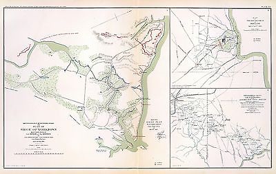
Plate 014
|
Reconnaissance of secession works and plan of Siege of Yorktown. Made
under orders of Gen'l. Barnard and Maj. Humphreys by Lieut. Abbot, Top. Engrs.,
Lieut. Comstock, Engrs., Lieut. Wagner, Top. Engrs. April and May 1862. Map
no. 1. siege plan ... (with) Map of the battle-field of Shiloh, April 6th
and 7th 1862. Accompanying report of Gen. G.T. Beauregard ... Topographical
sketch of the line of operations of the Army of the Ohio, under the command
of Major General D.C. Buell. Evacuation of Corinth by the enemy, May 30th,
1862 ... surveyed ... 1862 by N. Michler ... assisted by John E. Weiss (i.e.
Weyss) ... Julius Bien & Co., Lith., N.Y. (1891-1895) |

Plate 015
|
Reconnaissance of the secession works at Yorktown, Va. made by Lieut
Abbot, Topl. Eng'rs. and at Gloucester, Va. made by Lieut. Comstock, Eng'rs.,
May 4, 1862. For Gen. J.G. Barnard ... (with) Sketch exhibiting the position
of Yorktown with the approaches from reconnaissance and survey between the
5th and 10th of April 1862. By command of Maj. Gen. Geo. B. McClellan ...
A.A. Humphreys ... Reconnaissance of Red Redoubt Group to right of Yorktown
made by Lieut. N.G. Hall ... (with) The position of Yorktown with the approaches
from reconnaissances and surveys made by command of Maj. Gen. Geo. B. McClellan
..., prepared under the direction of Maj. A.A. Humphreys ... April 21st 1862.
Julius Bien & Co., Lith., N.Y. (1891-1895) |

Plate 016
|
Part of the map of the Military Department of Southeastern Virginia and
Fort Monroe. Compiled in the Bureau of Topographical Engineers of the War
Department, August 1861. Julius Bien & Co., Lith., N.Y. (1891-1895) |

Plate 017
|
Part of the map of the Military Department of Southeastern Virginia and
Fort Monroe showing the approaches to Richmond and Petersburg. Compiled in
the Bureau of Topographical Engineers of the War Department. 1861. (with)
Picket line of First Brigade and reconnaissance toward Lee's Mill, Va., April
28, 1862. (with) Reconnaissance toward Lee's Mill, Va., April 28, 1862. Julius
Bien & Co., Lith., N.Y. (1891-1895) |

Plate 018
|
Copy of a map. Sheet no. 1 military reconnaissance, Department of Virginia,
Major-General Wool commanding. Drawn by Sergt. Ch. Worret and compiled under
the direction of Col. T.J. Cram, Chief Top. Engrs., Dept. Va. (with) Campaign
maps, Army of the Potomac. Map no. 1 Yorktown to Williamsburg. Prepared by
command of Maj. Gen. George B. McClellan ..., Brig. Gen. A. A. Humphreys
... Map compilation under the direction of Brig. Gen. A.A. Humphreys, by
Capt. H.L. Abbot, Top. Engrs., September 1862. Julius Bien & Co., Lith.,
N.Y. (1891-1895) |

Plate 019
|
Campaign maps, Army of the Potomac. Map no. 3. White House to Harrison's
Landing. Prepared by command of Maj. Gen. George B. McClellan ... Brig. Gen.
A.A. Humphreys, Chief of Top. Engrs., Army of the Potomac. (with) Official
plan of the Siege of Yorktown, Va. conducted by the Army of the Potomac under
the command of Maj. Gen. George B. McClellan, U.S.A., April 5th to May 3rd
1862. Prepared under the direction of Brig. Gen. J.G. Barnard ... by Lieut.
Henry L. Abbot ... (with) Campaign maps, Army of the Potomac. Map no. 2.
Williamsburg to White House ... (with) Sketch no. 1, Mulberry Island, Va.
(with) Sketch no. 2. Principal work on Mulberry Island, Va. Julius Bien &
Co., Lith., N.Y. (1891-1895) |

Plate 020
|
Map of the Battle-grounds in the vicinity of Richmond, Va. Chief Engineer's
Office D.N.V., Col. J.F. Gilmer, Chf. Engr. Made under the direction of A.H.
Campbell, Capt. P.E. and Chf. Topl. Dept. 1862 and 3. (with) Reconnaissance
of part of the rebel works in front of Williamsburg, evacuated May 6th 1862,
by M.D. McAlester, Lt. Eng'rs., May 6th 1862. (with) Sketch of the battle-field
and Confederate works in front of Williamsburg, Va., May 5th, 1862, by Lieut.
M.D. McAlester, Chief Engr., 3rd. Corps, Army of the Potomac. (with) Battle-field
and rebel works in front of Williamsburg, Va. Battle of 5th May 1862 ...
Julius Bien & Co., Lith., N.Y. (1891-1895) |

Plate 021
|
Rough sketch of reconnaissance, May 24th, 1862 (by) R.H. Rush, Col. Lancers.
Map illustrating the Battle of Hanover, Va., May 27, 1862. Accompanying report
of Brig. Gen. John H. Martindale ... Engagement near Hanover Court-House,
Va., May 27, 1862. Accompanying report of Col. S.W. Stryker ... Reconnaissance
made on the afternoon of May the 23d, 1862 (by) Alexander Doull ... Map of
march from Mount Airey to Old Church, Va., May 23rd 1862 ... accompanying
report of Col. R.O. Tyler ... Skirmish between two rebel batteries and Battery
B, 1st Md. Arty., June 5th, 1862 at New Bridge, Va. Accompanying report of
Captain A. Snow ... Battle of Mechanicsville, Va., June 26 and 27, 1862.
Accompanying report of Brig. Gen. T. Seymour ... Sketch of the Battle of
New Market, Va., June 30, 1862 ... Map to accompany the report of Brig. Gen.
J.E.B. Stuart ... commanding Pamunkey Expedition to the enemy's rear, June
13, 14 and 15, 1862 ... Malvern Hill, Va., Morrell's Division, July 1st,
1862. Engagement near Hanover Court-House, Va., May 27, 1862. Accompanying
report of Brig. Gen. D. Butterfield ... Topography of the battle-field of
Cross Keys, Va. by Lieut. Col. John Pilsen ... Accompanying report of Maj.
Gen. J.C. Fremont ... Map of route and positions, First Corps, Army of Virginia,
Major General Sigel, commanding from July 7th to Sept. 10th 1862 (by) Franz
Kappner, Maj. and Chf. Engr. Julius Bien & Co., Lith., N.Y. (1891-1895) |

Plate 022
|
Map of the operations of the Cavalry Brigade commanded by Brig. Gen.
J.E.B. Stuart from 25th June to 10th July 1862. Prepared by Capt. Wm. W.
Blackford ... Map no. 2, operations of the Army of Virginia under Maj. Gen.
John Pope. Battle-field of Cedar Mountain, August 9th 1862. W. Hoelcke ...
Map no. 5, operations of the Army of Virginia ... Battle-field of Manassas,
Va., close of the action August 29th, 1862. W. Hoelcke ... Map of the
battle-field of Bull Run, August 29th and 30th 1862. Surveyed by order of
Maj. Gen. Sigel under direction of Maj. Kappner by G. Stengel and U. de
Fonvielle, November 1862. Map of the field operations of the Army of Virginia
during the months of July and August 1862. Map no. 4, operations of the Army
of Virginia under Maj. Gen. John Pope. Position of troops at sunset August
28th 1862. W. Hoelcke. Map no. 3, operations of the Army of Virginia under
Maj. Gen. John Pope. Position of troops on the night of August 27th 1862.
W. Hoelcke. Julius Bien & Co., Lith., N.Y. (1891-1895) |

Plate 023
|
Map of route and positions, First Corps, Army of Virginia. Major General
Sigel, commanding, from August 27th to Sept. 1st 1862. Map of the engagement
at Secessionville, James Island, S.C., June 16, 1862. Department of the Gulf,
map no. 7. Grand Lake Region. Prepared by order of Maj. Gen. N.P. Banks.
Henry L. Abbot ... Feb. 3rd, 1863. (with) Operations of Stuart's cavalry
division around Groveton, Aug. 1862. (with) Map of route taken by scouting
party under Maj. Gen. J.E.B. Stuart August 1862. Drawn by Wm. W. Blackford
... (with) Map to accompany the report of Maj. Gen. J.E.B. Stuart of the
operations of the Cavalry Division during the advance of the Army of Northern
Virginia toward the Rappahannock in August 1862. Drawn by Capt. W.W. Blackford
... (with) Map of cavalry expedition to Catlett's Sta., Major General Stuart,
commd'g., Aug. 22d. 1862. Drawn by Wm. W. Blackford ... (with) Diagram showing
the position of the 3d. Brigade on the battle field, October 3, 1862. (with)
Diagram showing the field of battle, October 3rd and 4th, 1862. Julius Bien
& Co., Lith., N.Y. (1891-1895) |

Plate 024
|
Section of map prepared to exhibit the campaigns in which the Army of
the Cumberland took part during the War of the Rebellion by order of Maj.
Gen. Geo. H. Thomas, U.S.A. Compiled under the direction of Brevt. Maj. Gen.
Z.B. Tower ... by Ed. Ruger ... assistants Capt. A. Kilp and Lieut. R. Flach,
U.S. Colored Artillery (Heavy) and Asst. Top. Engrs. ... (with) Topographical
plan of the city and battle-field of Baton Rouge, La. fought on the 5th of
August 1862 drawn by Joseph Gorlinski ... (with) Map of the battle-field
of Perryville, Ky ... October 8th 1862. Surveyed and compiled by order of
Major General George H. Thomas, U.S.A. (with) Map of the battle-field of
Perryville, Ky ... prepared by Walter J. Morris. (with) E. Sketch showing
the position of the attacking and defending forces at the Siege of Washington,
N.C., March 29 to April 16, 1863. Report of Maj. Gen. J.G. Foster ... Julius
Bien & Co., Lith., N.Y. (1891-1895) |

Plate 025
|
Plan of the battle of Corinth fought on the 3d and 4th of October,1862,
between the Confederate forces under Major Generals Van Dorn, Price and Lovell
and the United States forces under Major General Rosecrans. Accompanying
official report respectfully forwarded (by) W.S. Rosecrans. (with) Map of
the ground on which was fought the battle of Iuka, Miss. on the 19th of September
1862. (with) Sketch of engagement at Bayou Fourche, Ark. September 10, 1863
... report of Col. John M. Glover ... (with) Sketch showing positions of
pontoon bridges and guns covering them at Fredericksburg, Va., December 11-15,
1862 ... report of Lieut C.B. Comstock ... (with) Map showing the intrenchments
around Wilmington. Surveyed and mapped under the direction of Capt. W.H.
James ... by L.C. Turner, C.E., 1863 ... (with) Map of route followed by
the Cavalry Division through Maryland into Pennsylvania under command of
Maj. Gen. J.E.B. Stuart October 1862. Prepared by Wm. W. Blackford ... Julius
Bien & Co., Lith., N.Y. (1891-1895) |

Plate 026
|
Military map of Suffolk and vicinity for Brig. Gen. E.L. Viele. Surveyed
and drawn by Oscar Soederquist ... (with) Plan of Fort Esperanza, Tex. (with)
Map of Morris Island and the adjacent creeks. From U.S. Coast Survey 1823-4.
Sand hills from a survey 6th June 1862 ... indorsement (sic) of Gen. G.T.
Beauregard ... (with) Proposed secondary line of defense on the peninsula
between Ashepoo and Combahee Rivers, S.C., November 4, 1863 ... letter from
Brig. Gen. W.S. Walker ... ... Julius Bien & Co., Lith., N.Y. (1891-1895) |

Plate 027
|
Part of map of portions of the military departments of Washington,
Pennsylvania, Annapolis and Northeastern Virginia. Compiled in the Bureau
of Topographical Engrs., War Department &c., July 1861 ... report of
Maj. Gen. Geo. B. McClellan ... and Maj. A.J. Myer ... Battle-fields of South
Mountain showing the positions of the forces of the United States and of
the enemy during the battle fought by the Army of the Potomac under the command
of Maj. Gen. Geo. B. McClellan, Sept. 14, 1862. Prepared in the Bureau of
Topographical Engineers. (with) Map accompanying Lieutenant General Pemberton's
report of operations near Vicksburg, Miss., December 21, 1862, January 2,
1863. Surveyed and drawn by H.A. Pattison, Civil Engr. Julius Bien &
Co., Lith., N.Y. (1891-1895) |

Plate 028
|
Map of the battle of the Antietam fought on the 16th and 17th September
1862 between the United States forces under the command of Maj. Gen. Geo.
B. McClellan and the Confederates under Gen. Robert E. Lee. Prepared ...
under the direction of 1st Lt. Nicholas Bowen ..., 1st Lt. A.H. Cushing ...,
Chas. Shoemacker, E.F. Bowke, Jos. McMakin, C.A. Mallory, assts. ... October
1862. (with) Map of the battle of the Antietam ... sketched under the direction
of Capt. J.C. Duane ... by Maj. D.C. Houston ..., Lt. N. Bowen, Lt. Js. H.
Wilson, Lt. Jno. M. Wilson ..., Lt. W.A. Roebling ..., W.S. Long ..., Jos.
McMackin ... (with) Engagement at deserted house or Kelly's Store near Suffolk,
Va., January 30th 1863 (with) Battle-field of Gettysburg, July 1-4, 1863.
Drawn by Thomas Peters ... (with) Map of the position of the cavalry during
the engagement of April 4th 1863 ... (with) Map of that portion of the
battle-field of Antietam occupied by the troops under Maj. Gen. Burnside
... from surveys made under the supervision of Capt. R.S. Williamson ...
by H.C. Fillebrown, E.S. Waters, Civ. Eng'rs. Julius Bien & Co., Lith.,
N.Y. (1891-1895) |

Plate 029
|
Antietam. Prepared by Bvt. Brig. Gen. N. Michler, Major of Engineers
from surveys under his direction ... 1867. Compiled and drawn by Maj. J.E.
Weyss, assisted by F. Theilkuhl, J. Strasser and G. Thompson. ... Map of
the battle-fields of Harper's Ferry and Sharpsburg with position of troops,
routes of Army &c., Sept. 13 to 17, 1862 ... by S. Howell Brown, 1st.
Lieut. Engr. Troops ... Jan. 27, 1864. To accompany report of General Robert
E. Lee, C.S. Army. Julius Bien & Co., Lith., N.Y. (1891-1895) |

Plate 030
|
10. New map of Tennessee by Capt. Michler, Topl. Engineers, U.S.A. (with)
9. Topographical sketch of the battle-field of Stone's River near
Murphreesborough, Tenn., December 31st 1862 to January 3d. 1863. Maj. Gen.
W.S. Rosecrans ... Forces of the United States. General Braxton Bragg commanding
enemy's forces. (with) Position of 1st Division 3rd Corps at noon December
13, 1862. Drawn by direction of Brig. Gen. D.B. Birney ... (by) J.C. Briscoe
... (with) Position held by the 1st Division 3rd Corps after having repulsed
the enemy December 13, 1862. Drawn by direction of Brig. Gen. D.B. Birney
... (by) J.C. Briscoe ... (with) Map of Huntersville line commanded by Col.
Wm. L. Jackson. (with) Sketch showing the positions of Liddell's division
consisting of Walthall's and Govan's brigades in the Battle of Chickamauga,
September 18, 19 and 20, 1863. Accompanying report of Brig. Gen. St. John
R. Liddell, C.S. Army. Julius Bien & Co., Lith., N.Y. (1891-1895) |

Plate 031
|
Map of the battle of Murfreesborough fought Dec. 30th, 1862 to Jan. 3d.,
1863, between the Confederate forces under General Bragg and Federal forces
under Major General Rosecrans. (with) "1" Map of the Stone's River Campaign.
C. Meister, draughtsman ... (with) Map showing the movements of Johnson's
brigade and Darden's attached battery in the battle before Murfreesborough,
Tenn., Dec. 31, 1862. ... accompanying report of Brig. Gen R.B. Johnson ...
(with) Sketch of the Battle of Fredericksburg, Saturday Dec. 13th 1862, Right
Wing, C.S.A., Lieutenant General Jackson's Corps by Jed. Hotchkiss. (with)
Survey of fortifications and environs of Tullahoma between the Shelbyville
and Lynchburg roads. Drawn by J.H. Haney. (with) Map of the battle-field
of Thompson's Hill, Port Gibson showing the positions of the 9th Div., 13th
Army Corps commanded by Brig. Gen. P.J. Osterhaus, May 1, 1863. Sketched
by F. Tunica, engineer. Julius Bien & Co., Lith., N.Y. (1891-1895) |

Plate 032
|
Bb. Plan of the battles on Stone's River before Murfreesborough. Gen.
Bragg, commdg. Confederate Army, Maj. Gen. Rosecrans, commdg. Federal Army,
Dec. 31, 1862, Jan. 1, 2, 3, 1863. ... by Walter J. Morris ... (with) Position
of the divisions of Humphreys, Whipple, Griffin and Sykes at the battle of
Fredericksburg on Dec. 13th, 1862. (with) V. Plan of Sabine Pass, of its
defenses and means of communication. J. Kellersberg(er) ... October 15th,
1863. (with) Rebel fortifications, Grand Gulf, Miss. Surveyed May, 1863,
drawn October, 1863 by H.A. Ulffers, Asst. Engr. (with) Skirmishes near Liberty
Gap, Tenn., June 24-26, 1863 ... report of Brig. Gen St. John R. Liddell,
C.S. Army. (with) Map of the approaches to Little Rock, Ark., made under
directions from Maj. Gen. Sterling Price ... by Capt. T.J. Mackey, C.S. Engrs.,
August, 1863 ... Julius Bien & Co., Lith., N.Y. (1891-1895) |

Plate 033
|
Fredericksburg. Prepared by Bvt. Brig. Gen. N. Michler ... by order of
... A.A. Humphreys. 1867. (with) Map exhibiting the route of the Sioux Expedition
under the command of Brig. Gen. H.H. Sibley, 1863. Compiled and projected
by John H. Wagner ... (with) Map of the fight of the 14th A.C. at Buzzard
Roost, Ga., February 24th, 25th and 26th, 1864 by Theo. Wiseman, A.A. ...
(with) Sketch of battle of Big Mound, fought July 24th, 1863 by the expeditionary
forces commanded by Brigadier General H.H. Sibley. Sketched and drawn by
Joseph McCloud. (with) Sketch of the battle at Dead Buffalo Lake, July 26th,
1863, commanded by Brig. Gen. H.H. Sibley. (with) Map accompanying report
of the battle of Dry Fork Creek, Mo., on the 5th of July, 1861 ... report
of Capt. T.W. Sweeny ... Julius Bien & Co., Lith., N.Y. (1891-1895) |

Plate 034
|
Vicinity of Readyville, Bradyville and Woodbury. Compiled ... under the
direction of Capt. W.E. Merrill. Printed in the field by Capt. W.C. Margedant's
new method for field map printing. June 28th, 1863. Capt. W.C. Margedant's
new method for quick field maps ... (Manchester, Jackborough, McMinnville)
(with) No. 1. Shelbyville and vicinity from general information by Capt.
W.E. Merrill ... June 10th, 1863. (with) Quick map July 4th, 1863. Compiled
under the direction of Capt. W.E. Merrill ... (with) Quick map, July 5th,
1863. Compiled under the direction of Capt. W.E. Merrill ... Julius Bien
& Co., Lith., N.Y. (1891-1895) |

Plate 035
|
Vicinity of Decherd. Compiled in the field ... under the direction of
Capt. W.E. Merrill ... printed ... by Capt. Margedant's new method for field
map printing, July 20th, 1863. Manchester and vicinity ... July 24, 1863.
Sketch of Tullahoma, Tenn. and vicinity ... July 6th, 1863. Proposed road
along south bank of new canal from Duckport to Walnut Bayou, thence barges
towed by Victor to Richmond. Accompanying letter of ... W.T. Sherman ...
Jasper and vicinity ... July 24, 1863. Chattanooga and vicinity ... July
20th, 1863. Shelbyville and vicinity. From a survey by Capt. C. Dunham ...
July 17th, 1863. Julius Bien & Co., Lith., N.Y. (1891-1895) |

Plate 036
|
Map of the country between Milliken's Bend, La. and Jackson, Miss. showing
the routes followed by the Army of the Tennessee under the command of Maj.
Gen. U.S. Grant, U.S. Vls. in its march from Milliken's Bend to rear of Vicksburg
in April and May 1863. Compiled, surveyed and drawn under the direction of
Lt. Col. J.H. Wilson ... Drawn by Maj. Otto H. Matz ... and 1st Lieut. L.
Helmle ... Map of the siege of Vicksburg, Miss. by the U.S. forces under
the command of Maj. Gen. U.S. Grant ... Maj. F.E. Prime, Chief Engr. Surveyed
and constructed under direction of Capt. C.B. Comstock ... by Major Otto
H. Matz ..., Chs. Spangenberg ..., Lieuts. Patton, Karnasch and Helmle ...,
L. Zwanziger, S.R. Tresilian, B. Barth, S. Hartwell, asst. engrs. Drawn by
Chs. Spangenberg ... Julius Bien & Co., Lith., N.Y. (1891-1895) |

Plate 037
|
Map of the defenses of Vicksburg, Miss. Saml. H. Lockett, Maj. &
Chf. Engr. ... Surveyed & drawn by H.A. Pattison, C.E., Feb. 1863. (with)
Map of Jackson and vicinity. Compiled from surveys made May 14th to 16th
and July 10th to 21st, 1863 by Capt. W.L.B. Jenney ... (with) Map of Jackson,
Miss. and vicinity showing the position of the United States and rebel works
... July 20th, 1863. Prepared under direction of 1st Lieut P.C. Hains ...
from surveys by Lieuts. Hains and McComas by Lieut W.R. McComas and Mr.
Hazeltine. (with) Military map of Vicksburg and vicinity. Compiled and surveyed
by order of Major General W.T. Sherman by Capt. Juls. Pitzman. (with) Map
of the siege of Jackson, Miss. by U.S. forces under command of Maj. Gen.
W.T. Sherman, 9th to 17th July, 1863. (with) Map of Big Black River railroad
bridge and vicinity showing intrenchments ... May 17th, 1863. Surveyed,
intrenchments constructed, and drawn by F. Tunica, engineer. (with) Map of
battle-field of Big Black River bridge, Miss. showing the positions of the
U.S. troops at the moment Gen. Lawler charged the ... enemy's line, May 17th,
1863. Prepared under the direction of Lieut. P.C. Hains ... by F. Mason,
Act. Asst. Engineer. Julius Bien & Co., Lith., N.Y. (1891-1895) |

Plate 038
|
Galveston, Tex. and its fortifications. Map of siege operations against
the defenses of Charleston Harbor, 1863 showing batteries covering the descent
upon Morris Island, July 10 and the subsequent operations resulting in the
demolition of Ft. Sumter, and the capture of Ft. Wagner and Batty. Gregg,
September 7 ... 1863. Q. Gillmore, Major-General commanding and Chief Engineer
.... Map of Port Hudson, La. and vicinity. Prepared by order of Major D.C.
Houston, Chief Engineer, Department of the Gulf and Captain Peter C. Hains,
Corps of Engr's., 1864. Julius Bien & Co., Lith., N.Y. (1891-1895) |

Plate 039
|
Map of the Rappahannock River from Port Royal to Richards Ferry. Drawn
from surveys made by officers of the Engineer Brigade and charts of the Coast
Survey of the river below Fredericksburg, under direction of Brig. Gen. D.P.
Woodbury. Map of the field-operations of the Army of the Potomac under Major
General Joseph Hooker in the battles with the army of General Lee near
Chancellorsville and Fredericksburg between April 27th and May 7th, 1863
... by Brig. Gen. G.K. Warren, Capt. Engineers ... (with) Engineer Office,
Hd. Qrs. Expeditionary Corps, July 15th, 1863. Map illustrating the operations
of the U.S. forces against Jackson, Miss. Compiled from the survey of Capt.
Pitzman, May 14th-16th and from the surveys ... since July 10th. (with) Portions
of the Middle Department, 2nd Division, 8th Army Corps. Prepared by Capt.
W. Angelo Powell ... Winchester, June, 1863. Julius Bien & Co., Lith.,
N.Y. (1891-1895) |

Plate 040
|
Map of the approaches to Petersburg and their defenses, 1863. By order
of the Engineer Bureau, Col. J.F. Gilmer ... Col. W.H. Stevens ... Capt.
Chas. H. Dimmock, C.S.E., in charge of defenses, Petersburg, Va. Map of the
battle-field of Gettysburg, Pa. July 1, 2 and 3, 1863. (with) B. Sketch showing
route of the Burnside Expedition. Accompanying report of Maj. Gen. J.G. Foster,
C.S. Army ... (with) C. Sketch showing the route to New Berne pursued by
the Burnside Expedition, March 13 and 14, 1862. (with) Map showing the positions
of Maj. Gen. S.G. French's forces at Lovejoy's Station, Ga. from Sept. 3d.
to Sept. 8th, 1864. Julius Bien & Co., Lith., N.Y. (1891-1895) |

Plate 041
|
Sketch of the battles of Chancellorsville, Salem Church and Fredericksburg,
May 2, 3 and 4, 1863. Prepared by order of General R.E. Lee, by Jed. Hotchkiss,
Topogl. Engr., 2d. Corps, A.N.V. (with) Map of the action at Dranesville,
Va., December 20th, 1861. U.S. forces commanded by Brig. Gen. E.O.C. Ord.
Drawn by H.H. Strickler ... 1875. Julius Bien & Co., Lith., N.Y. (1891-1895) |

Plate 042
|
Military map showing the topographical features of the country adjacent
to Harper's Ferry, Va. including Maryland, Loudoun and Bolivar heights and
portions of South and Short mountains with the positions of the defensive
works, also the junction of the Potomac and Shenandoah rivers and their passage
through the Blue Ridge. Surveyed from August 3d to Sept. 30th 1863 under
the direction of Capt. N. Michler, Corps of Engrs., U.S. Army, by Major John
E. Weyss ... Army of the Potomac. Map of the vicinity of Hagerstown, Funkstown,
Williamsport and Falling Waters, Md. Accompanying the report of Major General
G.G. Meade on the Battle of Gettysburg dated October 1st 1863. (with) Battle
of Slaughter's Mountain, sketch of field August 9, 1862. (with) Sketch of
that part of field at Cold Harbor where Ewell's Division operated, particularly
where Trimble's Brigade fought, June 27, 1862. (with) Sketch of the battle-field
of Cross Keys, Va., June 8, 1862. ... Julius Bien & Co., Lith., N.Y.
(1891-1895) |

Plate 043
|
Map of the battle-field of Gettysburg with positions of troops, July
2nd, 1863. Topl. Office, A.N.V., by L. Howell Brown ... copied by Hoffmann.
Accompanying report of Gen. R.E. Lee, C.S. Army. (with) Sketch of the battle
of Gettysburg, July 1st, 2nd and 3rd, 1863 to accompany report of Lieut.
Gen. R.S. Ewell ... by Jed. Hotchkiss. (with) Sketch of the second battle
of Winchester, June 13th, 14th and 15th, 1863 ... by Jed. Hotchkiss. (with.
Marietta Region) Accompanying report of Brig. Gen. K. Garrard. (with Dallas
Region) Marked "McPherson" by Gen. Sherman. (with Dallas Region) Marked
"McPherson" by Gen. Sherman. (with) Sketch of routes, 2nd Corps A.N.V. from
Fredericksburg, Va. to Gettysburg, Pa. and return to Orange C.H., Va. from
June 4th 1863 to August 1st, 1863. To accompany report of Lieut. Gen. R.S.
Ewell ... by Jed. Hotchkiss. (with) Texas Coast showing points of occupation
of expedition under Maj. Gen. N.P. Banks, November 1863. (with Dallas Region).
Marked "McPherson" by Gen. Sherman. Julius Bien & Co., Lith., N.Y.
(1891-1895) |

Plate 044
|
Plan of a portion of the siege operations against the defenses of Charleston
Harbor showing the left batteries. Executed by order of Maj. General Q.A.
Gillmore under the direction of Maj. T.B. Brooks, A.D.C., Lieut. C.R. Suter,
U.S.E., Lieut. P.S. Michie, U.S.E., assistant engineers. Plate IV. ... Plan
of a portion of the siege operations against the defenses of Charleston Harbor
prior to the capture of Fort Wagner, Sept. 7, 1863. Executed by order of
Major-General Q.A. Gillmore ... Plate III. Sketch showing the operations
of the Army of the Potomac from Nov. 26 to Dec. 3, 1863. Julius Bien &
Co., Lith., N.Y. (1891-1895) |

Plate 045
|
Map of Orange County &c., Va. embracing the details and plan of
operations of Confederate and Federal forces at Mine Run and Rapidan River
by order of ... W.P. Smith, Lt., Col. of Engrs., Topl. Office, A.N.V. Prepared
by J. Paul Hoffman. Accompanying report of General R.E. Lee, C.S. Army. (with)
Part of map of portions of the military departments of Washington, Pennsylvania,
Annapolis and Northeastern Virginia. Compiled in the Bureau of Topographical
Engrs., War Department &c., 1861. Accompanying report of Capt. L.B. Norton
... (with Decatur, Howard's Plantation). From original in possession of Gen.
W.T. Sherman. (with Brownings C.H.-Stone Mountain) C.B. Reese, Capt. Engrs.
From original in possession of Gen W.T. Sherman. (with Campbellton Region)
Accompanying letter of Maj. Gen. George Stoneman. (with) Map to show lines
of march of Second Army Corps and the enemy, Oct. 14, 1863 ... report of
... G.K. Warren. (with) Map of battle-field at Bristoe fought by 2d Army
Corps commanded by Maj. Gen. G.K. Warren, October 14, 1863. (with) Map of
Missionary Ridge, Tenn. showing the positions attacked by the forces under
the command of Maj. Gen. W.T. Sherman, Nov. 24th and 25th, 1863. Julius Bien
& Co., Lith., N.Y. (1891-1895) |

Plate 046
|
Sheet no. 1. Map of the battle-field of Chickamauga, September 19th,
1863 between the United States forces commanded by Maj. Gen. W.S. Rosecrans
and the rebel army under Gen. Braxton Bragg. Compiled under the direction
of Col. W.E. Merrell ... by Edward Ruger ... Sheet no. 2. Map of the battle-field
of Chickamauga, September 20th, 1863 ... (with) Map showing the expedition
of the 15th Army Corps, Maj. Gen. P.J. Osterhaus, commanding, Turkeytown
Valley, Ala., October 24-26, 1864. (with) Battle of Chickamauga, Walker Co.,
Georgia, Sept. 19 and 20, 1863. From original in the possession of General
Braxton Bragg, C.S. Army. Julius Bien & Co., Lith., N.Y. (1891-1895) |

Plate 047
|
Map of the fall campaigns of the Army of Missouri, Maj. Gen. Sterling
Price, commanding in Sept., Oct., Nov. 1864. Capt. T.J. Mackey, Chf. Engr.
(with) No. 2. Map of the battle of Chickamauga showing the positions of the
Confederate and Federal armies on the 19th September, 1863 ... by Walter
J. Morris ... (with) No. 3. Map of the battle of Chickamauga ... 19th September
1863 ... by Walter J. Morris ... (with Marietta Region, Georgia). Accompanying
letter of Maj. Gen. J.M. Scholfield ... (with Peach Tree Creek Region, Georgia)
Marked "Thomas" by Gen. Sherman. (with) Mine Run, Va. and vicinity, 1863.
(with) No. 1. Map showing the positions of the Confederate Army and that
of the Federal Army at midnight on the 18th of September, 1863, the night
previous to the general engagements of the 19th and 20th Sept., or the Battle
of Chickamauga ... by Walter J. Morris ... (with) Map of the engagement at
Wauhatchie, Tenn., October 28th and 29th, 1863 and of the operations of the
11th and 12th Army Corps preliminary thereto. Accompanying report of Maj.
Gen. Joseph Hooker. Julius Bien & Co., Lith., N.Y. (1891-1895) |

Plate 048
|
Map no. 1. The Chickamauga Campaign, August 16-September 22, 1863. E.G.
Anstey, draughtsman. Accompanying report of Gen. Braxton Bragg, C.S. Army.
Topographical map of the approaches and defenses of Knoxville, E. Tennessee,
showing the positions occupied by the United States and Confederate forces
during the siege. Surveyed by direction of Capt. O.M. Poe ... during Dec.,
Jan. and Feb., 1863-4 by Cleveland Rockwell, Sub. Asst., U.S. Coast Survey,
R.H. Talcott, aide. (with Dallas Line, Georgia). Accompanying letter of Maj.
Gen. Jas. B. McPherson ... (with Dallas Line, Georgia). Original marked
"McPherson May 27." From original in possession of Gen. W.T. Sherman. (with)
Sketch of roads from Gen. McCook's hdqrs. near junction of Acworth and Dallas
and Marietta roads to Acworth and Big Shanty and R.R. ... 1864. From original
in possession of Gen. W.T. Sherman. Julius Bien & Co., Lith., N.Y.
(1891-1895) |

Plate 049
|
Map of the battle-field of Chattanooga. Prepared to accompany report
of Maj. Gen. U.S. Grant. By direction of Brig. Gen. W.F. Smith ... 1864.
Compiled and drawn by C.S. Mergell. Position of troops, etc. drawn by E.
Hergesheimer. Map accompanying report of Maj. Gen. O.O. Howard. (with)
McPherson's crossing at Roswell. From original in possession of Gen. W.T.
Sherman. (with Marietta Region by) C.W. Skinner. Accompanying letter of Brig.
Gen. Garrard. (with Chattahoochee River) marked "Schofield" in Gen. Sherman's
handwriting. Julius Bien & Co., Lith., N.Y. (1891-1895) |

Plate 050
|
Battle of Lookout Mountain, Tenn., November 24, 1863. Map of the line
west of Chattanooga Creek. Accompanying report of Maj. Gen. Carter L. Stevenson,
C.S. Army ... (with) Map of country in vicinity of Brown's Ferry. Made to
accompany report of Brig. Gen. Wm. F. Smith ... Drawn ... Nov. 5, 1863 by
C.S. Mergell. (with) Map of the battle-field of Missionary Ridge showing
the positions of Maj. Gen. Sheridan's and Brig. Gen. T.J. Wood's divisions
... Novbr. 23, 24 and 25, 1863 under command of Maj. Gen. Gordon Granger.
(with) Map illustrating the positions of the Second Division, Fourth Army
Corps, under the command of Maj. Gen. P.H. Sheridan, U.S. Army in front of
Chattanooga, Tenn., November 23 to 25, 1863. (with) Chattanooga and vicinity.
Accompanying report of Maj. Gen. C.L. Stevenson, C.S. Army |
This auction is for a series of e-books
on
DVD
Please check our other
items.
This item is Windows AND Mac compatible, it
requires the FREE Adobe Acrobat Reader, version 6 or higher or some otherprogram
that will read PDF files.
MOST modern computers already have this software
installed but for those who do not it is available FREE.
|
|
Can I print the books? |
YES, you can print a single page or the entire book. |
Can I adjust the page size? |
YES, the page size can be increased many times larger or smaller to fit your
reading style, or to examine illustrations in more detail. |
Can I copy pictures and illustrations
from the books? |
YES, you can copy images from the e-book for use in other
programs. |
Do I need an Internet connection to use the
ebook? |
NO, the e-book is self -contained and does not require an Internet
connection. |
| Does the ebook every
"expire"? |
NO, the e-book does not expire, once you buy it it's
your's. |
|
Ad and DVD copyright 2012
Euriskodata
All Rights Reserved |
The free listing tool. List your items fast and easy and manage your active items.
|