Click Here. Double your traffic. Get Vendio Gallery - Now FREE!
Rare Map Collection
This DVD is part of our Historic Map and
Atlas Collection.
We have dozens of Atlas maps on DVD and CD ranging from the 1500s
to the 1900s covering many areas and topics.
Please Check our Ebay Store for what's available. |
FOR MANY MORE EDUCATIONAL CD
TITLES
ON THIS AND MANY OTHER
SUBJECTS
PLEASE VISIT OUR EBAY STORE |
VERY LARGE HIGH RESOLUTION
MAP COLLECTION
ON DVD!!
(please see full table of contents and sample
illustrations below) |
|
This DVD Contains
110 Maps
of
North and South
Dakota
Including 11 PANORAMIC MAPS of various
North and South Dakota Cities
These are scans of the ORIGINAL maps
by various Cartographers.
on DVD
System requirements
PC or Mac compatible.
Files are simple PDF files with a basic HTML
interface (just like viewing a webpage)
Works with ALL versions of Windows.
|
Maps of
North and South
Dakota

0041034
|
Dakota. Shows townships, etc. Prime meridians: Greenwich and Washington.
Asher & Adams
1874 |

0565025
|
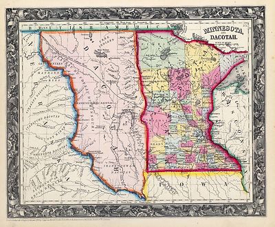
Minnesota, And Dacotah
Mitchell, Samuel Augustus
1860 |

0586043
|
Dakota.Shows counties, Indian reservations, settlements, railroads, rivers,
etc.
Mitchell, Samuel Augustus
1880 |

0594043
|
Dakota. Relief shown by hachures. Shows counties, Indian reservations,
settlements, railroads, rivers, etc.
Mitchell, Samuel Augustus
1890
|

0806002
|
Road map N. & S. Dakota.
Relief shown by hachures and spot heights. Indexed. Includes table of gasoline
taxes.
Rand McNally and Company; Texas Company
1937 |

1070008
|
Dakota Territory
The territory is largely unsurveyed. Surveying has only been completed in
a few townships right along the Missouri River. The map shows the treaty
line of July 23, 1851.
U.S. General Land Office
1866 |

1172001
|
Reconnoissances in the Dacota Country.
Detailed, large scale maps of eastern Nebraska of the period. Map is without
color.
Warren, Gouverneur Kemble
1856 |

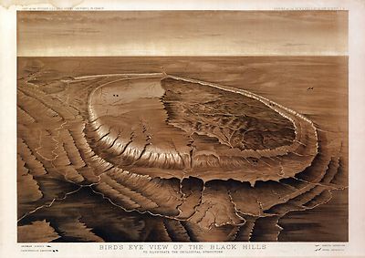
2083002
|
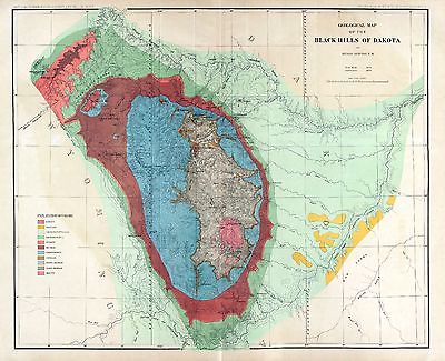
Map of the Black Hills of Dakota. Relief shown by hachures. Includes
3-line note on Sioux Reservation. Geographical and Geological Survey of the
Rocky Mountain Region (U.S.);
Jenney, Walter Proctor; Newton, Henry; M'Gillycuddy, V. T.; Tuttle, H. P.;
Mahlo, Emil
1879 |

2083003
|
Map of the Black Hills of Dakota. Relief shown by contours, hachures
and spot heights. Includes 3-line note on Sioux Reservation. Geographical
and Geological Survey of the Rocky Mountain Region (U.S.);
Jenney, Walter Proctor; Newton, Henry; M'Gillycuddy, V. T.; Tuttle, H. P.;
Mahlo, Emil
1879 |

2212238
|
Partie, Nouvelle Bretagne. Amer. Sep. 33.
Relief shown pictorially. Covers parts of Saskatchewan, Manitoba, Ontario,
Montana, North Dakota and Minnesota.
Vandermaelen, Philippe
1827 |

2239025
|
Nebraska, and the territories of Dakota, Idaho, Montana and Wyoming.
Lloyd, H. H.
1873 |

2246001
|
Post route map of the Territory of Dakota.
United States. Post Office Dept. ; Nicholson, W. L.
1885 |

2449089
|
Vereinigte Staaten Von Nord-Amerika In 6 Blattern, Bl. 2.includes Dakota,
Nebraska, Minnesota, North and South Dakota, Wisconsin, and part of Illinois.
In outline color.
Stieler, Adolf
1875 |

2710030
|
Nebraska, and the territories of Dakota, Idaho, Montana and Wyoming.
Walling, H. F.; Gray, Ormando Willis; Lloyd, H. H.
1872 |

2769001
|
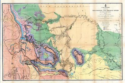
Map Of The Yellowstone And Missouri Rivers.
Hayden, F.V.
1869 |

2905029
|
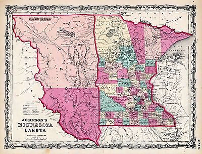
Minnesota And Dakota.
Johnson, A.J.
1860 |

3131001
|
Land grant NPRR. Map showing surveyed portion of land grant of Northern
Pacific Railroad Company from Jamestown, North Dakota, to Montana boundary
line ... (1895)
Shows railroads, counties, quarter sections, railroad lands sold and for
sale, government lands settled and unoccupied, and those reserved for schools,
Indian and military reservations, etc. Very detailed land map showing parcels
sold and for sale.
Northern Pacific Railroad Company
1895 |

3131A
|
Land grant NPRR.
Map showing surveyed portion of land grant of Northern Pacific Railroad Company
from Jamestown, North Dakota, to Montana boundary line ... (1895)
Northern Pacific Railroad Company
1895 |

3131B
|
Text PAge. Land grant NPRR.
Map showing surveyed portion of land grant of Northern Pacific Railroad Company
from Jamestown, North Dakota, to Montana boundary line ... (1895)
Northern Pacific Railroad Company
1895 |

3565137
|
South Dakota.
Rand McNally and Company
1897 |

3565138
|
North Dakota.
Rand McNally and Company
1897 |

3966000
|
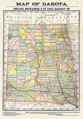
Map of Dakota.
Rand McNally and Company
1892 |

4520043
|
Dakota.
States in outline color by county. Relief shown by hachures. Shows named
railroads.
Rand McNally and Company
1879 |

4645000
|
Territory Of Dakota.
Department Of The Interior General Land Office J.A. Williamson, Commissioner.
Territory Of Dakota. 1879. Compiled from the official Records of the General
Land Office and other sources. Good detail on the Black Hills
U.S. General Land Office
1879 |

4747000
|
Map Of Chicago & North-Western Railway Lines (To) Dakota.
Chicago and North Western Railway Company
1880 |

5243001
|
Correct map of Dakota.Relief shown by hachures. Shows townships, Indian
and military reservations, railroads, etc. Includes inset map by Poole Bros.
showing railroads from Chicago to Montana and Wyoming
Chicago and North Western Railway Company
1888 |

5243A
|
Central Dakota. U.S. railroad maps, 370 (1882 ed.); Checklist of printed
maps of the Middle West to 1900, 10-0222 and 11-0571 (1882 ed.)
Chicago and North Western Railway Company
1888 |

5243B
|
Text Page: Central Dakota. Answers to your questions about Central Dakota
reached by the Chicago and North-Western Railway
Chicago and North Western Railway Company
1888 |

5244001
|
St. Paul, Minneapolis & Manitoba Ry.
Shows townships, etc. Inset maps: Map showing the location of Osakis, Alexandria,
& Ashby. Summer resorts on the line of the St. Paul Minneapolis &
Manitoba Ry. -- (Canadian Pacific, St. Paul, Minneapolis & Manitoba Ry.
and other routes from Winnepeg to the Pacific coast)
St. Paul, Minneapolis & Manitoba Railway Company.
1887 |

5244B
|
(Text Page to) St. Paul, Minneapolis & Manitoba Ry. Red River Valley
Line through the park region .
St. Paul, Minneapolis & Manitoba Railway Company.
1887 |

5370020
|
Dakota.
Map in full color by county. The railroad lines are clearly marked.
Cram Atlas Company
1875 |

ct000088
|
Geographical and Geological Survey of the Rocky Mountain Region (U.S.)
Report on the geology and resources of the Black Hills of Dakota, with atlas.
By Henry Newton, E.M., and Walter P. Jenny., E.M.
1880 |

ct000904
|
Plan of the N.W. frontier / from Governor Clarke.
1813?
|

ct001237r
|
Rand McNally and Company.
Map showing the land grant of the Northern Pacific Railroad Company in Montana,
Idaho, and in part of North Dakota, and in part of eastern Washington, reaching
from Dickinson, North Dakota, to Ritzville, eastern Washington.
c1890
|

pm003890
|
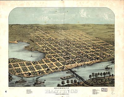
Ruger, A.
Bird’s eye view of the city of Hastings, Dakota Co., Minnesota 1867.
Drawn by A. Ruger.
1867
|

pm006720
|
Stoner, J. J.
View of the city of Bismarck, Dak. Capital of Dakota and county-seat of
Burleigh-County 1883. Beck & Pauli, lithographers.
c188[3] |

pm006730
|
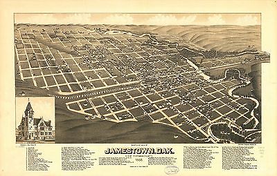
Stoner, J. J.
Bird’s eye view of Jamestown, Dak., c.s. of Stutsman County 1883. Beck
& Pauli, lithographers.
c1883
|

pm006740
|
Stoner, J. J.
Bird’s eye view of Mandan, Dak., county seat of Morton Co. 1883. Beck
& Pauli, lithographers.
c1882 |

pm008850
|
Wellge, H. (Henry)
Birds eye view of Aberdeen, Dak. H. Wellge, del.
1883 |

pm008860
|
Stoner, J. J.
Bird’s eye view of Clark, Dakota, county seat Clark Co. 1883. Beck &
Pauli, lithographers.
c1882
|

pm008880
|
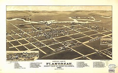
Brosius, H.
Bird’s eye view of Flandreau, county seat of Moody Co., Dakota 1883.
H. Brosius, del. Beck & Pauli, lithographers.
c1882 |

pm008890
|
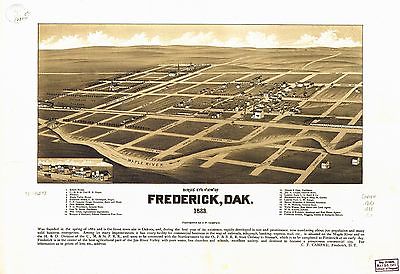
Campau, C. F.
Bird’s eye view of Frederick, Dak. 1883. [By] C. F. Campau.
1883 |

pm008900
|
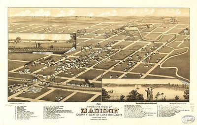
Brosius, H.
1883 bird’s eye view of Madison, county seat of Lake Co. Dakota. H.
Brosius, del. Beck & Pauli, lithographers.
c1882
|

pm008910
|
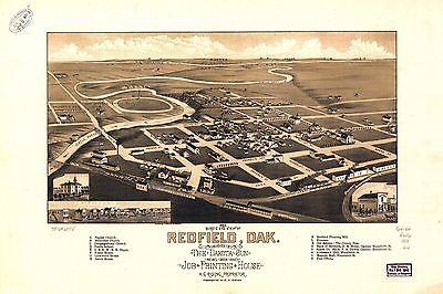
Wellge, H. (Henry)
1883 bird’s eye view of Redfield, Dak. Drawn by H. Wellge. Copyrighted
by H. G. Rising.
1883
|

pm008920
|
Stoner, J. J.
Bird’s eye view of Watertown, Dak. county-seat of Codington Co. 1883.
Beck & Pauli, lithographers.
1883 |

rr001540
|
Lambert, John, topographer.
St. Paul to Riviere des Lacs : from explorations and surveys / made under
the direction of the Hon. Jefferson Davis, Secretary of War by Isaac I. Stevens
Governor of Washington Territory, 1853-4.
1859 |

rr002760
|
Higbee, E. F.
Sectional map of the state of North Dakota published by authority of the
commissioners of railroads under the direction of the governor; drawn and
compiled from official maps of the General Land Office and other authentic
sources.
1892 |

rr003020
|
Rand McNally and Company.
Indexed county and township pocket map and shippers guide of South Dakota.
1892 |

rr003700
|
Rand McNally and Company.
Correct map of Dakota compiled from United States and Territorial surveys
Nov. 1, 1882
1882 |

0149054
|

0151058
|

0152062
|

0352041
|

0352042
|

0358047
|

0425110
|

0425111
|

0572037
|

0579040
|

0592045
|

0693021
|

0993002
|

1550056
|

1582001
|

1780033
|

2054054
|

2094049
|

2134082
|

2284000
|

2307023
|

2452003
|

2579002
|

2585074
|

2844069
|

2861016
|

3005002
|

3031003
|

3054008
|

3054009
|

3471001
|

3493002
|

3888043
|

3918001
|

3918002
|

3918003
|

4498002
|

4502002
|

4557036
|

4587062
|

4727032
|

4740050
|

4809003
|

4825056
|

4835046
|

4872004
|

4872005
|

4875000
|

4977066
|

5005000
|

5041041
|
5243A
|

5244A
|
5244B
|

5250001
|

5250A
|

5250B
|

5299000
|

5479095
|

5479097
|

5755023
|

5784042
|

6322182
|

6727038
|
|
|
|
Features of this DVD
This auction is for a DVD of the maps listed
in electronic form,
NOT
the maps
themselves.
These maps are VERY high resolution and
can be printed at FULL SCALE or LARGER for framing and display. The results
are very high quality and convincing. |
|
Ad and disk copyright 2013
Euriskodata
All Rights Reserved |
The free listing tool. List your items fast and easy and manage your active items.
|