Click Here. Double your traffic. Get Vendio Gallery - Now FREE!
Rare Map Collection
This DVD is part of our Historic Map and
Atlas Collection.
We have dozens of Atlas maps on DVD and CD ranging from the 1500s
to the 1900s covering many areas and topics.
Please Check our Ebay Store for what's available. |
FOR MANY MORE EDUCATIONAL CD
TITLES
ON THIS AND MANY OTHER
SUBJECTS
PLEASE VISIT OUR EBAY STORE |
VERY LARGE HIGH RESOLUTION
MAP COLLECTION
ON DVD!!
(please see full table of contents and sample
illustrations below) |
|
This DVD Contains
123 Maps
of
Arkansas
These are scans of the ORIGINAL maps
by various Cartographers.
on DVD
System requirements
PC or Mac compatible.
Files are simple PDF files with a basic HTML
interface (just like viewing a webpage)
Works with ALL versions of Windows.
|
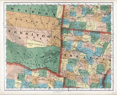
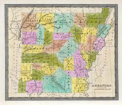
Arkansas Map Collection

0041014
|
Arkansas, Indian Territory. Shows townships, distances along railroads,
etc. Prime meridians: Greenwich and Washington.
Asher & Adams
1874 |

0089035
|
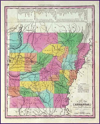
Arkansas
Bradford, Thomas G.
1838 |

0149042
|
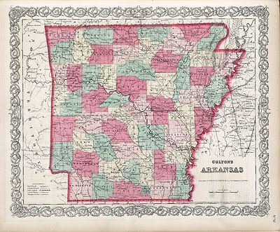
Arkansas.
Colton, G.W.
1856 |

0537026
|
New Map Of Arkansas.
Mitchell, Samuel Augustus
1846 |

0977022
|
New Map Of Arkansas
Tanner, Henry S.
1836 |

1070010
|
Arkansas. Map in outline color. Coal regions are shown in gray.
U.S. General Land Office
1866 |

1780053
|
Parts Arkansas, Louisiana.
Confederate States of America. Army
1895 |

1780157
|
Arkansas Gen. map XIX.
Julius Bien & Co.; United States. War Department
1895 |

2301029
|
Arkansas
Morse, Sidney Edwards ; Breese, Samuel
1845 |

2743006
|
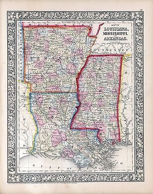
Arkansas, Louisiana und Mississippi.
Lange, Henry
1854 |

3565130
|
New business atlas map of Arkansas.
Rand McNally and Company
1897 |

4453037
|
Arkansas.
Goodrich, S.G. ; Bradford, Thomas G.
1841 |

4584070
|
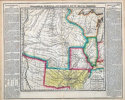
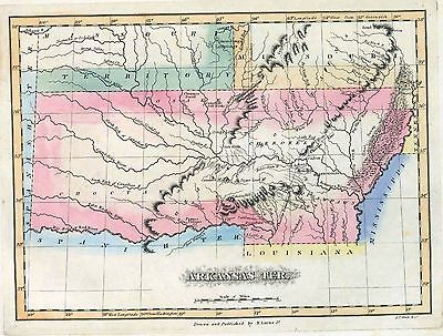
Arkansas Territory
Lucas, Fielding Jr.
1823 |

4628050
|
Arkansas.
Burr, David H.
1835 |

4807162
|
Arkansas.
Meyer, Joseph
1845 |

4850050
|
Arkansas.
Greenleaf, Jeremiah
1840 |

4966014
|
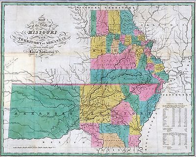
Map of the states of Mississippi, Louisiana and the Arkansas Territory.
Hinton, John Howard; Hinton, Isaac Taylor; Simpkin & Marshall.
1832 |

5370021
|
Arkansas.
Cram Atlas Company
1875 |

5457000
|
State of Arkansas.
U.S. General Land Office
1878 |

ct000818
|
Shall, D. F.
Colton’s railroad & township map of Arkansas complied from the U.S.
Surveys and other authentic sources.
1854
|

ct001271
|
Geological Survey of Arkansas.
Map of Washington County / John C. Branner, state geologist ; Frederic W.
Simonds, assistant geologist.
1888 |

cw0115000
|
Fendall, C.
Approaches to Fort Hindman, Arkansas Post, on the Arkansas River : captured
by the U.S. Mississippi Squadron, under command of Act’g. Rear Admiral
David D. Porter, U.S.N., January 11th, 1863 / surveyed by C. Fendall, sub.
assistant, U.S. Coast Survey, acting under orders of Rear Admiral D.D. Porter
; U.S. Coast Survey, A.D. Bache, supdt.; autographic transfer, J.W. Maedel.
1863
|

cw0115200
|
United States. Navy.
View of Fort Hindman, Arkansas Post. [January 11, 1863]
1863 |

cw0116000
|
United States. Army. Corps of Engineers.
Map of the battlefield of Pea Ridge, Arkansas, showing the positions of the
United States and Confederate forces on the 8th of March 1862 From a map
forwarded to the Engineer Department Sept. 11th 1865 by Brevet Brig. Gen.
C. B. Comstock A.D.C.
1876
|

cw0230000
|
Holtz, Helmuth.
Map of Louisiana & Arkansas. Prepared under direction of 1st Lieut. Wm.
Hoelcke, 39 U.S. Infty, acting Chief Engineer at hd. qts. Dept. of La., by
Helmuth Holtz.
1864? |

la002009
|
Knobel, G.
Hope, Hempstead Co., Ark. / G. Knobel, Cil. Engr.
Texarkana, Ark. : Wilson Engineering & Supply Co
1916 |

mf000044
|
United States. Topographical Bureau.
Map showing the lands assigned to emigrant Indians west of Arkansas and Missouri.
1836 |

pm000120
|
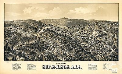
Wellge, Henry
Bird’s eye view of Hot Springs, Ark. Drawn by H. Wellge, Beck &
Pauli Lith. Co.
1888? |

pm000130
|
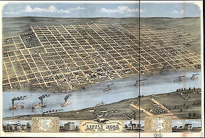
Ruger, A.
Bird’s eye view of the city of Little Rock, the capitol of Arkansas
1871. Drawn & published by A. Ruger.
1871 |

pm000140
|
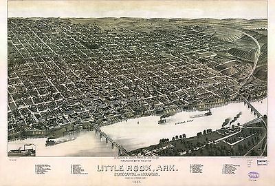
Henry Wellge & Co.
Perspective map of the city of Little Rock, Ark., State capital of Arkansas,
county seat of Pulaski County. 1887. Beck & Pauli Lith. Co.
1887 |

pm000150
|
Henry Wellge & Co.
Perspective map of, Texarkana, Texas and Arkansas. Beck & Pauli Lith.
1888?
|

pm000160
|
Wellge, H. (Henry)
Perspective map of Van Buren, Ark. county seat of Crawford County 1888. H.
Wellge, sk. Beck & Pauli Lith. Co.
1888
|

pm010910
|
Hot Springs, Arkansas
Woodward & Tiernam Printing Co.
c1890. |

rr001340
|
Burr, David H.
Map of Mississippi, Louisiana & Arkansas exhibiting the post offices,
post roads, canals, rail roads, &c. / by David H. Burr (late topographer
to the Post Office), Geographer to the House of Representatives of the U.S.
1839
|

rr001470
|
Sidell, William Henry, 1810-1873.
Map of the route surveyed from the Mississippi at Lake Providence in Louisiana
to the great bend of Red river at Fulton in Arkansas / under the orders of
Col. J. J. Abert, Chief of the Corps of Topographical Engineers by W. H.
Sidell, Civil Engineer, 1850.
1850 |

rr001830
|
Shall, D. F.
Colton’s railroad & township map of Arkansas complied from the U.S.
Surveys and other authentic sources.
1854 |

rr001840
|
Cram, George Franklin, 1841-1928.
Cram’s township and rail road map of Arkansas.
1895 |

rr001850
|
Rand McNally and Company.
The Rand McNally indexed county and township pocket map and shippers guide
of Arkansas showing all railroad, cities, towns, villages, post offices,
lakes, rivers, etc.
1898 |

rr003200
|
G.W. & C.B. Colton & Co.
Maps showing Arkansas Central, the Helena & Corinth, and the Pine Bluff
& Southwestern Railroads together forming the Texas & Northeastern
Railway.
1872 |

rr003580
|
Wilamowicz, I.
Map of the Cairo & Fulton Railroad exhibiting the principal tributary
lines as projected and its connections with other railroads west of the
Mississippi River, which unite with the Missouri Pacific Railroad, and south
projected Pacific Railroad via Elpaso [sic] to the Pacific Ocean, showing
also the connection by rail road of the cities of New Orleans & St. Louis.
Little Rock, Ark. Sep. 1853.
1853 |

rr004430
|
G.W. & C.B. Colton & Co.
Maps showing the connections of the Little Rock and Fort Smith Railroad and
its land grant.
1873 |

rr004440
|
United States. General Land Office.
Map of Franklin County, Arkansas; showing the land grant of the Little Rock
& Fort Smith Railway.
1893 |

rr004570
|
Woodward, Tiernan, and Hale.
Map of the lands of the Memphis & Little Rock Railroad Company (as
reorganized)
1878
|
0041014
|
Arkansas, Indian Territory. Shows townships, distances along railroads,
etc. Prime meridians: Greenwich and Washington.
Asher & Adams
1874 |
0089035
|
Arkansas
Bradford, Thomas G.
1838 |
0149042
|
Arkansas.
Colton, G.W.
1856 |
0537026
|
New Map Of Arkansas.
Mitchell, Samuel Augustus
1846 |
0977022
|
New Map Of Arkansas
Tanner, Henry S.
1836 |
1070010
|
Arkansas. Map in outline color. Coal regions are shown in gray.
U.S. General Land Office
1866 |
1780053
|
Parts Arkansas, Louisiana.
Confederate States of America. Army
1895 |
1780157
|
Arkansas Gen. map XIX.
Julius Bien & Co.; United States. War Department
1895 |
2301029
|
Arkansas
Morse, Sidney Edwards ; Breese, Samuel
1845 |
2743006
|
Arkansas, Louisiana und Mississippi.
Lange, Henry
1854 |
3565130
|
New business atlas map of Arkansas.
Rand McNally and Company
1897 |
4453037
|
Arkansas.
Goodrich, S.G. ; Bradford, Thomas G.
1841 |
4584070
|
Arkansas Territory
Lucas, Fielding Jr.
1823 |
4628050
|
Arkansas.
Burr, David H.
1835 |
4807162
|
Arkansas.
Meyer, Joseph
1845 |
4850050
|
Arkansas.
Greenleaf, Jeremiah
1840 |
4966014
|
Map of the states of Mississippi, Louisiana and the Arkansas Territory.
Hinton, John Howard; Hinton, Isaac Taylor; Simpkin & Marshall.
1832 |
5370021
|
Arkansas.
Cram Atlas Company
1875 |
5457000
|
State of Arkansas.
U.S. General Land Office
1878 |
ct000818
|
Shall, D. F.
Colton’s railroad & township map of Arkansas complied from the U.S.
Surveys and other authentic sources.
1854
|
ct001271
|
Geological Survey of Arkansas.
Map of Washington County / John C. Branner, state geologist ; Frederic W.
Simonds, assistant geologist.
1888 |
cw0115000
|
Fendall, C.
Approaches to Fort Hindman, Arkansas Post, on the Arkansas River : captured
by the U.S. Mississippi Squadron, under command of Act’g. Rear Admiral
David D. Porter, U.S.N., January 11th, 1863 / surveyed by C. Fendall, sub.
assistant, U.S. Coast Survey, acting under orders of Rear Admiral D.D. Porter
; U.S. Coast Survey, A.D. Bache, supdt.; autographic transfer, J.W. Maedel.
1863
|
cw0115200
|
United States. Navy.
View of Fort Hindman, Arkansas Post. [January 11, 1863]
1863 |
cw0116000
|
United States. Army. Corps of Engineers.
Map of the battlefield of Pea Ridge, Arkansas, showing the positions of the
United States and Confederate forces on the 8th of March 1862 From a map
forwarded to the Engineer Department Sept. 11th 1865 by Brevet Brig. Gen.
C. B. Comstock A.D.C.
1876
|
cw0230000
|
Holtz, Helmuth.
Map of Louisiana & Arkansas. Prepared under direction of 1st Lieut. Wm.
Hoelcke, 39 U.S. Infty, acting Chief Engineer at hd. qts. Dept. of La., by
Helmuth Holtz.
1864? |

0027012.jpg
|
0041014.jpg
|

0041041.jpg
|

0073013.jpg
|
0089035.jpg
|

0102035.jpg
|

0104009.jpg
|

0122030.jpg
|
0149042.jpg
|

0151048.jpg
|

0152047.jpg
|

0278012.jpg
|

0280012.jpg
|

0315008.jpg
|

0341002.jpg
|

0341004.jpg
|

0352032.jpg
|

0358037.jpg
|

0425011.jpg
|

0535030.jpg
|
0537026.jpg
|

0545029.jpg
|

0565019.jpg
|

0572028.jpg
|

0579029.jpg
|

0586027.jpg
|

0592029.jpg
|

0594028.jpg
|
0977022.jpg
|
1070010.jpg
|

1550043.jpg
|

1690090.jpg
|
1780053.jpg
|
1780157.jpg
|

1954094.jpg
|

2054036.jpg
|

2094040.jpg
|

2134077.jpg
|
2301029.jpg
|

2307020.jpg
|

2372002.jpg
|

2392000.jpg
|

2483025.jpg
|

2544007.jpg
|

2710034.jpg
|

2738086.jpg
|

2738112.jpg
|
2743006.jpg
|

2809048.jpg
|

2844060.jpg
|

2915005.jpg
|

2980001.jpg
|

3050002.jpg
|

3327001.jpg
|

3471009.jpg
|
3565130.jpg
|

3565145.jpg
|

3803030.jpg
|

3825012.jpg
|

3884012.jpg
|

3888032.jpg
|

4217001.jpg
|

4328028.jpg
|
4453037.jpg
|

4506002.jpg
|

4520028.jpg
|

4520050.jpg
|

4557026.jpg
|

4574027.jpg
|

4578026.jpg
|
4584070.jpg
|

4587047.jpg
|
4628050.jpg
|

4646000.jpg
|

4727040.jpg
|

4804002.jpg
|
4807162.jpg
|

4825046.jpg
|

4835034.jpg
|
4850050.jpg
|

4866057.jpg
|

4889003.jpg
|
4966014.jpg
|

4977030.jpg
|

5028118.jpg
|

5041029.jpg
|

5060000.jpg
|

5198024.jpg
|

5363026.jpg
|
5370021.jpg
|

5370027.jpg
|
5457000.jpg
|

5479076.jpg
|

5745053.jpg
|

5755029.jpg
|

5784028.jpg
|

6727028.jpg
|

6921125.jpg
|
|
|
Features of this DVD
This auction is for a DVD of the maps listed
in electronic form,
NOT
the maps
themselves.
These maps are VERY high resolution and
can be printed at FULL SCALE or LARGER for framing and display. The results
are very high quality and convincing. |
|
Ad and disk copyright 2013
Euriskodata
All Rights Reserved |
The free listing tool. List your items fast and easy and manage your active items.
|