Maps of
Nebraska

0149055
|
Colton, G.W.
Date: 1856
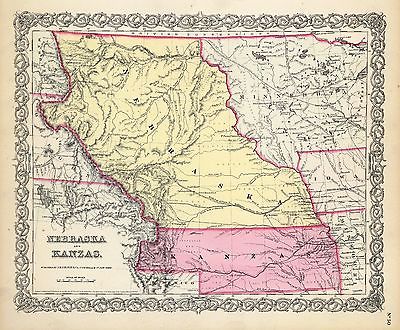
Nebraska And Kanzas.
|

2719001
|
Everts & Kirk
Date: 1885
Nebraska.
|

2773001
|
Fremont, J.C. ; Preuss, Charles
Date: 1846
Map Of The Road From Missouri To Oregon ... Section I.
|

2773002
|
, J.C. ; Preuss, Charles
Date: 1846
Map Of The Road From Missouri To Oregon ... Section II.
|

2773003
|
Fremont, J.C. ; Preuss, Charles
Date: 1846
Map Of The Road From Missouri To Oregon ... Section III.
|

2905028
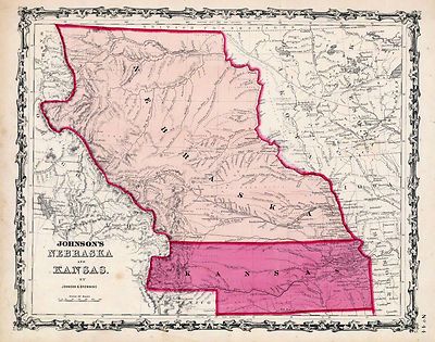
|
Johnson, A.J.
Date: 1860
Nebraska And Kansas.
|

3565136
|
Rand McNally and Company
Date: 1897
Nebraska.
|

3825008
|
Rogers, Henry Darwin ; Johnston, Alexander Keith, 1804-1871
Date: 1857
Territory of Nebraska.
|

3919A
|
Mid West Map Company
Date: 1920
Cover: Nebraska highway map.
|

3919B
|
Mid West Map Company
Date: 1920
Text Page: Nebraska highway map
|

4520038
|
Rand McNally and Company
Date: 1879
Nebraska.
|

4648000
|
U.S. General Land Office
Date: 1879
State Of Nebraska.
|

5370018
|
Cram Atlas Company
Date: 1875
Nebraska.
|

ct000891
|
J.H. Colton & Co.
Colton’s Kansas and Nebraska.
New York, 1855
|

ct001342
|
Hartley French Dickson & Co.
Map of the recently discovered gold regions in Western Kansas & Nebraska
/ from actual surveys notes & observations by Hartley French Dickson
& Co.
[S.l. : s.n, 1859?]
|

ct001346
|
Mitchell, D. T. (David T.)
Mitchell’s sectional map of Kansas / compiled from the field notes in
the Surveyor General’s office by David T. Mitchell, U.S. surveyor and
land agent, Lecompton, Kansas ; showing the U.S. survey up to 1859.
Lecompton, Kansas : David T. Mitchell , 1859.
|

cw0012700
|
Hall, Edward S.
Western border states Waters and son Eng.
N.Y., New York H. H. Lloyd & Co. c1861.
|

pm004620
|
Wellge, H. (Henry)
Perspective map of the city of Kearney, Neb. county seat of Buffalo Co. 1889.
H. Wellge, des.
Milwaukee, American Publishing Co. [1889]
|

pm004640
|
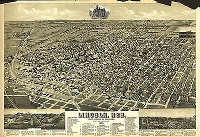
Wellge, H. (Henry)
Lincoln, Neb., State capitol of Nebraska, county seat of Lancaster Co. 1889.
H. Wellge, sk.
Milwaukee, American Publishing Co. [1889]
|

pm004650
|
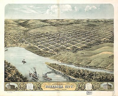
Ruger, A.
Bird’s eye view of the city of Nebraska City, Otoe County, Nebraska
1868. Drawn by A. Ruger.
Chicago, Merchants’ Lithogr. Co. [1868]
|

pm004660
|
Wellge, H. (Henry)
1889 perspective map of Norfolk, Neb. H. Wellge, sk.
Milwaukee, American Publishing Co. [1889]
|

pm004670
|
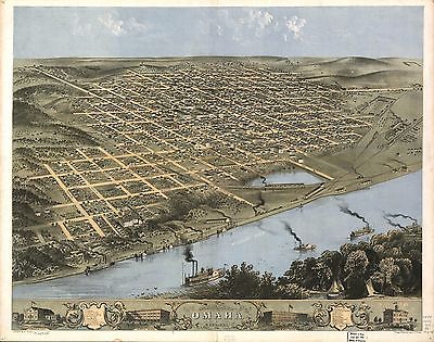
Ruger, A.
Bird’s eye view of the city of Omaha, Nebraska 1868. Drawn by A. Ruger.
Chicago, Chicago Lithographing Co. [1868]
|

pm004680
|
Austen, Edward J.
Panoramic view of Omaha. [Drawn by] Edw. J. Austen. 1905.
[Jefferson? Iowa] Bee Publishing Co., 1906.
|

rr001260
|
Mendenhall, Edward.
Traveling map of the western states, exhibiting the counties, towns and villages,
the rail ways, rivers, canals, and lakes and towns & stations on them;
engraved by Jos. Beutler.
Cincinnati, 1864, c1863.
|

rr001270
|
United States. General Land Office.
Map of Kansas and Nebraska.
Philadelphia, [1865]
|

rr001750
|
Fiala, John T.
General map of the United States & their territory between the Mississippi
& the Pacific Ocean. 1. Showing the different surveyed routes from the
Mississippi valley to the coast of Pacific Ocean, 2. the new established
& proposed Post Routes, 3. the recently discovered gold, silver, and
copper region in Kansas, Nebraska and Arizona. Compiled from the various
P.R.R. Surveys & the best authorities which could be obtained.
[n.p.], 1859.
|

rr002480
|
Asher & Adams.
[New commercial and topographical rail road map & guide of Nebraska].
New York, 1874.
|

rr002490
|
Hirschfield, F.
Map of Nebraska published by the Burlington Route 1886, compiled from the
official records of the government and rail road offices.
Omaha, 1886.
|

rr002500
|
Alt, W. W.
Railway map of Nebraska issued by State Board of Transportation 1889.
Wahoo, Nebraska, 1889.
|

rr002510
|
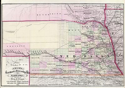
Cram, George Franklin, 1841-1928.
Cram’s rail road and township map of Nebraska.
Chicago, 1879, c1878.
|

rr002520
|
Galbraith, Frank H.
Galbraith’s railway mail service maps, Nebraska.
Chicago, 1897, c1898.
|

rr003530
|
G.W. & C.B. Colton & Co.
Map of the state of Nebraska showing the lands of the Burlington & Missouri
Riv. R.R. Co. in Nebraska.
New York, 1876.
|

rr005110
|
Williams, Henry T.
New trans-continental map of the Pacific R.R. and routes of overland travel
to Colorado, Nebraska, the Black Hills, Utah, Idaho, Nevada, Montana, California
and the Pacific Coast.
[n.p.], c1877.
|

rr005880
|
Dey, Peter Anthony, 1825-1911.
Union Pacific Rail Road, map of a portion of Nebraska Territory, showing
surveys and location of lines by Peter A. Dey, C.E.
[n.p., 1865?]
|

rr005930
|
Parge, H. R.
Map of Nebraska showing the Union Pacific Railroad land grant.
Omaha, 1880, c1879.
|

rrm05900
|
Gillis, J. R.
Map showing the different routes surveyed for the Union Pacific Rail Road
between the Missouri River and the Platte Valley, to accompany report of
Lt. Col. J.H. Simpson, Corps Engrs. to Hon. Jas. Harlan, Sec. of the Interior,
dated Sept. 18th, 1865; reduced from map submitted to Lt. Col. Simpson by
S. Seymour, Esq., Consulting Eng. U.P.R.R.
[Washington, D.C., 1865]
|

rrp05900
|
Gillis, J. R.
Map showing the different routes surveyed for the Union Pacific Rail Road
between the Missouri River and the Platte Valley, to accompany report of
Lt. Col. J.H. Simpson, Corps Engrs. to Hon. Jas. Harlan, Sec. of the Interior,
dated Sept. 18th, 1865; reduced from map submitted to Lt. Col. Simpson by
S. Seymour, Esq., Consulting Eng. U.P.R.R.
[Washington, D.C., 1865]
|

0027012
|

0073018
|

0151058
|

0152061
|

0352040
|

0352041
|

0358045
|

0358047
|

0392000
|

0393000
|

0425075
|

0502002
|

0535038
|

0535039
|

0572037
|

0579040
|

0586041
|

0592043
|

0594041
|

0834000
|

0960101
|

0993002
|

1070015
|

1071013
|

1173000
|

1550057
|

1582001
|

1582006
|

1690120
|

1698002
|

1700002
|

1700003
|

1954095
|

2041000
|

2043000
|

2054047
|

2094047
|

2134083
|

2194002
|

2212253
|

2307023
|

2449089
|

2483036
|

2585074
|

2769001
|

2809029
|

2844066
|

2861019
|

2871031
|

2905027
|

3471005
|

3493002
|

3873001
|

3888045
|

3919001
|

4084000
|

4096002
|

4117001
|

4117A
|

4117B
|

4323011
|

4324016
|

4325001
|

4421002
|

4422002
|

4552001
|

4557037
|

4567003
|

4574035
|

4574036
|

4587061
|

4703002
|

4727028
|

4825056
|

4872004
|

4872005
|

4931001
|

4932002
|

4933002
|

4968003
|

4977054
|

5028104
|

5028106
|

5028107
|

5028109
|

5041038
|

5155000
|

5193002
|

5213001
|

5479097
|

5755025
|

5755048
|

5784041
|

5797092
|

6727040
|

6727041
|

6921126
|
|
|
|