Features of this DVD
This auction is for a DVD of the maps listed
in electronic form,
NOT
the maps
themselves.
These maps are VERY high resolution and
can be printed at FULL SCALE or LARGER for framing and display. The results
are very high quality and convincing. |
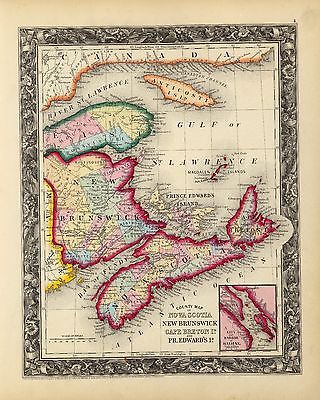
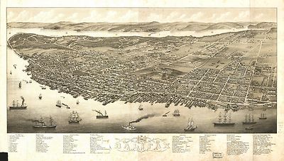
| This map of the province of Nova-Scotia and parts adjacent.1776 |
 |
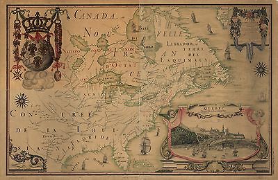
| Partie de l'Amérique septent? qui comprend la Nouvelle France
ou le Canada, par le Sr. Robert de Vaugondy, géog? ordinaire du roy.
Avec privilege 1755. C. Haussard, sculp. |
 |
| Canada et Louisiane, par le Sr. le Rouge ingénieur géographe
du Roy. 1755 |
 |
| A new map of Nova Scotia, and Cape Breton Island with the adjacent parts
of New England and Canada, composed from a great number of actual surveys;
and other materials regulated by many new astronomical observations of the
longitude as well as latitude; by Thomas Jefferys, geographer to the King.
1775 |
 |
| Partie orientale du Canada, traduitte de l'anglois de la carte de Jefferys
publiée a Londres en May 1755. |
 |
| Partie de l'Amérique septent? qui comprend la Nouvelle France
ou le Canada, par le Sr. Robert de Vaugondy, géog? ordinaire du roy.
Avec privilege 1755. C. Haussard, sculp. |
 |
| La Nouvelle France où Canada. 1764 |
 |
| A map of Canada and the north part of Louisiana with the adjacent countrys.
By Thos. Jefferys, geographer to His Majesty, 1762. |
 |
| A map of Canada and the north part of Louisiana with the adjacent countrys.
By Thos. Jefferys, geographer to His Majesty, 1762. |
 |
| Carte des possessions françoises et angloises dans le Canada,
et partie de la Louisiane, 1756. L. Thevenard fil. sculp. |
 |
| Partie occidentale de la Nouvelle France ou du Canada par Mr. Bellin,
ingénieur du roy de la marine pour servir à l'intelligence
des affaires de l'etat present en Amerique, communiquée au public
par les Héritiers de Homan. 1755 |
 |
| Map of the United States in part and Canada, showing all the canals,
railroads, navigable rivers &c. 1852 |
 |
| Hudson's Bay's country after La Veranderie, about 1740 / La Veranderie.Shows
lakes, rivers, fortifications, and nations in western region of Hudson Bay,
Canada, and northern United States. A sketch of the territory explored by
De la Veranderie. |
 |
| Map showing the route of the Chicago and Canada Southern Railway and
its connecting lines.1872 |
 |
| New railway map and guide of New York, Pennsylvania and New Jersey with
parts of adjoining states and Canada, 1881. |
 |
| Partie orientale du Canada. Traduitte de l'anglois de la carte de Jefferys
publiée à Londres en May 1755. |
 |
| Partie occidentale de la Nouvelle France ou Canada. Par Mr. Bellin, ingenieur
de la marine.1755 |
 |
| G. Woolworth Colton's railroad, township & distance map of New England
with adjacent portions of New York, Canada & New Brunswick.1861 |
 |
| Map of the country tributary to the Northern Pacific Railroad, compiled
from English, Canadian, and American official sources and original surveys
by Edward H. Knight, Jan. 1st 1871. Map of northwest part of United States
and southwest part of Canada showing relief by hachures, drainage, isotherms,
the wheat region, cities and towns, forts, routes and trails, the railroad
network and the proposed Northern Pacific Railroad. |
 |
| A correct map of the seat of war. 1812. |
 |
| Isothermal chart of the region north of the 36th Parallel &c. &c.
between the Atlantic & Pacific oceans; compiled under the direction of
Isaac I. Stevens, Govnr. of Washington Territory. 1859 |
 |
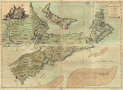
| Map of Nova Scotia, or Acadia; with the islands of Cape Breton and St.
John's, from actual surveys, by Captn. Montresor, engir. 1768 |
 |
| Lloyd's railroad, telegraph & express map of the United States and
Canadas from official information. 1867 |
 |
| Carte du Canada et des Etats-Unis de l'Amérique Septentrionale
/ par le Sr. Robert de Vaugondy, Géog. Ord. du Roi ... et Censeur
Royal. 1778 |
 |
| A map of Mackenzie's track from Fort Chipewyan to the Pacific Ocean in
1793. |
 |
| A map of Mackenzie's track from Fort Chipewyan to the north sea in 1789. |
 |
| City of Ottawa, Canada with views of principal business buildings.1895 |
 |
| Vue de Quebec, capitale du Canada. 1755 |
 |
| Carte du Canada et de la Louisiane qui forment la Nouvelle France et
des colonies angloises ou sont representez les pays contestez.1756 |
 |
| Winnipeg / entered according to Act of Parliament of Canada in the year
1884 by W.G. Fonseca in the Office of the Minister of Agriculture. |
 |
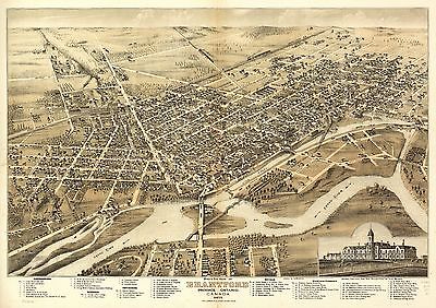
| Bird's eye view of Brantford, province Ontario, Canada 1875. Drawn by
H. Brosius. Chas. Shober & Co. prop's Chicago Lith. Co. |
 |
| The upper Mississippi and Missouri / by M. Soulard, 1795. Covers Northwestern
States and Western Canada. |
 |
| A map of America between latitudes 40 and 70 north and longitudes 45
and 180 west exhibiting Mackenzie's track from Montreal to Fort Chipewyan
& from thence to the north sea in 1789 & to the west Pacific Ocean
in 1793. |
 |
| Bowles's new pocket map of the United States of America; the British
possessions of Canada, Nova Scotia, and Newfoundland, with the French and
Spanish territories of Louisiana and Florida, as settled by the preliminary
articles of peace signed at Versailles the 20th. Jany. 1783. |
 |
| Map of Alaska, Yukon Territory and British Columbia showing connections
of the White Pass and Yukon route. 1904 Page 1 |
 |
| Map of Alaska, Yukon Territory and British Columbia showing connections
of the White Pass and Yukon route. 1904 Page 2 |
 |
| Carte des bayes, rades et port de Plaisance dans l'Isle de Terre-Neuve.
Dressé par M. Bellin pour l'Histoire du Canada par le P. Charlevoix.1755 |
 |
| A Plan of the Straits of St. Mary, and Michilimakinac, to shew the situation
& importance of the two westernmost settlements of Canada for the fur
trade. 175? |
 |
| A map of the New England states, Maine, New Hampshire, Vermont,
Massachusetts, Rhode Island & Connecticut with the adjacent parts of
New York & Lower Canada; compiled and published by Nathan Hale, Boston,
1826. |
 |
| New York, New Jersey, Pennsylvania, Delaware, Maryland, Ohio and Canada,
with parts of adjoining states. 1860 |
 |
| Map shewing the several routes proposed for the passage of gunboats to
the Lakes via: Erie and Oswego Canal; Champlain [Canal]; Illinois River and
Chicago [Canal]; Wisconsin, Green Bay [Canal] Prepared by S. H. Sweet, Dep.
State Engr. and Surveyor. 1862 |
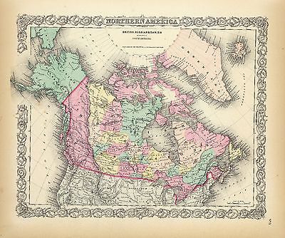
 |
| Amérique septentrion.lle [i.e. septentrionale] : composée,
corigée, et augmetée, sur les iournaux, mémoires, et
observations les plus justes qui en ón'etes.tes en l'année
1685 & 1686, par plusieurs particuliés / par I Baptiste Louis
Franquelin, g[éographe] du Roy.Covers Canada, Hudson Bay region,
and eastern United States. 1685 |
 |
| Carte de l'Amerique Septentrionnale : depuis le 25, jusqu'au 650 deg.
de latt. & environ 140, & 235 deg. de longitude / par Iean Baptiste
Louis Franquelin, hydrographe du roy, à Québec en Canada. 1688 |
 |
| Hudson's Bay's country / by P. Pond, 1785. |
 |
| Plan of a rout undertaken in winter, Jany. 26th, from Quebec, the capital
of Canada, to the frontier settlements of the Township of Topsham near Brunswick
Fort on the River Ammerascaegun in the Province of New Hampshire, Feby. 20th
1760 / John Montresor, sub. engr. & lieut. 1760? |
 |
| Telegraph stations in the United States, the Canadas & Nova Scotia.1853 |
 |
| A map of the sources of the Chaudière, Penobscot, and Kennebec
rivers, by Montresore.1761 |
 |
| A map of the north west parts of America, with the utmost respect, inscrib'd
to His Excellency, Sir Guy Carleton, Knight of the Bath: Captain General
and Governor of the province of Quebec: General and Commander in Chief of
His Majesty's forces in the said province, and frontiers thereof. &c.
&c. &c., by his most obedient humble servt. Alexr. Henry 1776? |
 |
| Map of the European and North American Railway, showing its connection
with the railways of the United States & Canada; made by direction of
His Excellency John Hubbard, Governor of Maine under the resolve of Aug.
20th 1850. |
 |
| Bird's eye view of Sherbrooke, P.Q. 1881 |
 |
| Victoria, B.C. 1889. |
 |
| Bird's eye view of Chatham, Ontario.1870 to 1880 |
 |
| A new and accurate map of the English empire in North America; Representing
their rightful claim as confirmed by charters and the formal surrender of
their Indian friends; likewise the encroachments of the French, with the
several forts they have unjustly erected therein. 1755 |
 |
| View of Victoria, Vancouver Island. Drawn by H. O. Tiedemann. T. Picken,
lith. 1860 |
 |
| Victoria, B.C. and vicinity 1884. By L. Samuel. Lithographed by the West
Shore. |
 |
| Salmon Canneries of the Pacific Northwest. 1901 |
 |
| Panoramic view of the city of Halifax, Nova Scotia 1879. [By] A. Ruger. |
 |
| Bird's-eye view of Victoria, Vancouver Island, B.C. 1878. Drawn by E.
S. Glover. A.L. Bancroft & Co., lithographers. |
 |
| Dominia Anglorum in America Septentrionali. Specialibus mappis Londini
primum a Mollio edita, nunc recusa ab Hommanianis Hered. A. Newfovndland,
od. Terra Nova S. Lavrentii Bay, die Fisch-Bank, Acadia, nebst einem Theil
New Schotland. 1759-1784 |
 |
| Canada, Louisiane, possessions angl? Par le S. Robert de Vaugondy,
géog? ord? du roi. Gravé par E. Dussy. 1762 |
 |
| Environs de Quebec: Bloque par les Americains du 8. decembre 1775 au
13. mai 1776. |
 |
| Map showing the most direct commercial route from the Atlantic via L.
Ontario, to the province of Upper Canada, the north western states &
territories, and to the Mississippi. 1836 |
 |
| Plan de la ville de Quebec.1755 |
 |
| St. Thomas. Drawn by H. Brosius. C.H. Vogt, lith. Printed by J. Knauber
& Co. 1896 |
 |
| A map of New England, and Nova Scotia; with part of New York, Canada,
and New Britain & the adjacent islands of New Found Land, Cape Breton
&c. By Tho. Kitchin geogr.1758 |
 |
| Hamilton, C.W. drawn by G.S. Rice ; lith. of Endicott & Co., N.Y.
1859 |
 |
| The United States of America with the British possessions of Canada,
Nova Scotia, & of Newfoundland, divided with the French; and the Spanish
territories of Louisiana and Florida according to the preliminary articles
of peace signed at Versailles the 20th of Jany. 1783. |
 |
| L'Amérique septentrionale divisée en ses principaux états
par le Sr. Janvier, géographe. Morillier, invenit. Berthault,
sculpcit.1762 |
 |
| A topographical map of Hudsons River, with the channels depth of water,
rocks, shoals &c. and the country adjacent, from Sandy-Hook, New York
and bay to Fort Edward, also the communication with Canada by Lake George
and Lake Champlain, as high as Fort Chambly on Sorel River. 1776. |
 |
| Plan, Lake Champlain from Fort St. John's to Ticonderoga, with the soundings,
rocks, shoals, and sands, surveyed in the years 1778, 1779. |
 |
| Plano del archipielago de Clayocuat situada su boca mas O. llamado Puerto
de Sn. Rafael por los 49020' de latd. N. y en la longd. de 20055' y la mas
E. nombrada de Clayocuat por los 4907' de la misma especie y 20022' al O.
del meridiano de Sn. Blas [?]conocidas sus bocas y descubiertos todos sus
brazos e islas interiores por el Thente. de Navio de la Rl. Armada Dn. Francisco
de Eliza Comandte. del Paguebot de S.M. nombrado San Carlos y Goleta Sta.
Saturnina (alias la Orcasitas) en este presente año de 1791. |
 |
| A plan of the division line between the provinces of New-York and Quebec.
In the 45th degree of north latitude. Survey'd in the year 1771 & 1772.
By Thomas Valentine & John Collins, esquirs. Drawn by C. J. Sauthier. |
 |
| Pensilvaniæ, Novæ-Cæsareæ, Novi-Eboraci,
Aquanishuonigæ et Canadæ, brevis delineatio, juxta itinera P.
Kalm a Ludovico Evans, 1750. Æri incisa a Fr. Akrel, cura S. Kreander. |
 |
| A map of the provinces of New-York and New-Yersey, with a part of
Pennsylvania and the Province of Quebec. From the topographical observations
of C. J. Sauthier. Engraved and published by Matthew Albert Lotter. 1777 |
 |
| A new and exact map of the dominions of the King of Great Britain on
ye continent of North America, containing Newfoundland, New Scotland, New
England, New York, New Jersey, Pensilvania, Maryland, Virginia and Carolina.
1715 |
 |
| A map of the British and French settlements in North America / T. Bowen,
sculpt[or]. Containing Canada, Nova scotia, Newfoundland, New England, part
of New York, with the Lakes, Six Nations, and all the countries westward
in the same parallels so far as discover'd; exhibiting the just boundaries,
and the French encroachments: laid down from authentic surveys 1755 |
 |
| A survey of Lake Champlain including Crown Point and St. Iohn's on which
is fixed the line of forty five degrees north lattit. terminating the boundarys
betwe[e]n the provinces of Quebec and New York agre[e]able to his Majesty's
proclamation done by order and instruction of the Honourable James Murray,
esqr., Governor of the Province of Quebec and the Honourable His Majestys
Council by Iohn Collins, depy. surv. genl., May 21th 1765. Charles Blaskowitz,
draughtsman. 1765 |
 |
| J. Sage & Son's new & reliable rail road map comprising all the
railroads of the United States and Canadas with their stations and distances,
compiled from the most acurate statistics. 1858 |
 |
| The provinces of New York and New Jersey; with part of Pensilvania, and
the Province of Quebec. Drawn by Major Holland, Surveyor General, of the
Northern District in America. Corrected and improved, from the original
materials, by Governr. Pownall, Member of Parliament, 1776. |
 |

0009015
|

0009020
|

0009022
|

0028050
|

0028051
|

0036040
|

0036041
|

0036042
|

0073002
|

0073004
|

0089003
|

0089004
|

0121001
|

0122003
|

0149012
|

0149013
|

0149014
|

0149015
|

0151018
|

0151019
|

0152018
|

0152019
|

0152020
|

0152021
|

0197004
|

0285005
|

0315003
|

0352015
|

0352016
|

0436058
|

0466067
|

0466068
|

0466069
|

0466070
|

0537004
|

0537005
|

0565004
|

0565005
|

0565006
|

0632002
|

0632003
|

0890126
|

0890128
|

0890129
|

0977003
|

0977004
|

1007060
|

1007061
|

1603198
|

2113095
|

2113096
|

2113099
|

2113100
|

2113101
|

2113102
|

2844084
|

3388001
|

3471003
|

3471012
|

3565055
|

3825004
|

3825005
|

5007004
|
| 5007004 Mitchell, John, Raynal, G.T. … La Parte Occidentale della
N … 1778 |
0009015 Alaskan Boundary Tribunal, B … Facsimile: Bouchette's Briti
… 1831 |
| 0009020 Alaskan Boundary Tribunal, H … Facsimile: Hudsons Bay Compa
… 1850 |
0009022 Alaskan Boundary Tribunal, A … Facsimile: Map of North Amer
… 1857 |
| 0028050 Lewis, Samuel, Arrowsmith, A … Louisiana. Engraved map,
uncolored. Relief shown by hachures. Covers the western U.S. and much of
Canada and northern Mexico. Shows settlements, Indian tribes, rivers, etc. |
0028051 Arrowsmith, Aaron, Lewis, Sa … British possessions in Ameri
… 1812 |
| 0036040 Arrowsmith, John British North America. 1837 |
0036041 Arrowsmith, John Upper Canada. 1837 |
| 0036042 Arrowsmith, John Lower Canada. 1837 |
0037000 Arrowsmith, John British North America |
| 0073002 Bartholomew, John, Black, Ad … British America. 1856 |
0073003 Bartholomew, John, Black, Ad … Canada, West Sheet. 1856 |
| 0073004 Bartholomew, John, Black, Ad … Canada, New Brunswick, Nova
… 1856 |
0089003 Bradford, Thomas G. Upper Canada. 1838 |
| 0089004 Bradford, Thomas G. Lower Canada and New Brunswi … 1838 |
0121001 Canada Government Railways Map Shewing the Railways of …
1886 |
| 0122003 Carey, H. C., Lea, I. Map Of Upper And Lower Canad … 1822 |
0149012 Colton, G.W. British, Russian & Danish Po … 1856 |
| 0149013 Colton, G.W. New Brunswick, Nova Scotia, … 1856 |
0149014 Colton, G.W. Canada East Or Lower Canada … 1856 |
| 0149015 Colton, G.W. Canada West or Upper Canada. 1856 |
0151018 Colton, G.W. Canada East or Lower Canada … 1865 |
| 0151019 Colton, G.W. Canada West or Upper Canada. 1865 |
0152018 Colton, G.W. Dominion of Canada. Provinces of Quebec and New
Brunswick. 1869 |
| 0152019 Colton, G.W. Dominion of Canada. The Province of Ontario. 1869 |
0152020 Colton, G.W. Dominion of Canada. The Provinces of New Brunswick
& Nova Scotia and Prince Edward Island. … 1869 |
| 0152021 Colton, G.W. New Brunswick; Nova Scotia; Prince Edward Island;
Newfoundland … 1869 |
0197004 Cornell, S. S. (Sarah S.) British Provinces of North A …
1864 |
| 0285005 Finley, Anthony Canada. 1831 |
0315003 Grigg, John British America. 1830 |
| 0352015 Johnson, A.J. Lower Canada And New Brunswi … 1864 |
0352016 Johnson, A.J. New Brunswick, Nova Scotia, … 1864 |
| 0436058 Lizars, Daniel No. America British possessi … 1831 |
0466067 Martin, R.M., Tallis, J. & F … British America. 1851 |
| 0466068 Martin, R.M., Tallis, J. & F … West Canada. 1851 |
0466069 Martin, R.M., Tallis, J. & F … East Canada And New Brunswic
… 1851 |
| 0466070 Martin, R.M., Tallis, J. & F … Nova Scotia And Newfoundland
… 1851 |
0537004 Mitchell, Samuel Augustus Canada East Formerly Lower C …
1846 |
| 0537005 Mitchell, Samuel Augustus Canada West Formerly Upper C …
1846 |
0565004 Mitchell, Samuel Augustus County Map Of Nova Scotia Ne …
1860 |
| 0565005 Mitchell, Samuel Augustus Map Of Canada East In Counti …
1860 |
0565006 Mitchell, Samuel Augustus Map Of Canada West In Counti …
1860 |
| 0632002 Morse, Jedidiah New Map of Upper & Lower Can … 1794 |
0632003 Morse, Jedidiah New Map of Nova Scotia, New … 1794 |
| 0890126 Society for the Diffusion of … British North America. 1834 |
0890128 Society for the Diffusion of … Nova-Scotia, N.B., Lower
Can … 1832 |
| 0890129 Society for the Diffusion of … Lower-Canada, N.B., N.Y.,
Vt … 1832 |
0977003 Tanner, Henry S. Lower Canada. 1836 |
| 0977004 Tanner, Henry S. Upper Canada. 1836 |
1007060 Thomson, John Canada, Nova Scotia. 1817 |
| 1007061 Thomson, John United States of America. 1817 |
1603198 USSR (Union of Soviet Social … 187. Canada, Political. The
… 1967 |
| 2113095 Bartholomew, J. G. (John Geo … Dominion of Canada - politic
… 1922 |
2113096 Bartholomew, J. G. (John Geo … North-eastern Canada. 1922 |
| 2113099 Bartholomew, J. G. (John Geo … Maritime Provinces &
Newfoun … 1922 |
2113100 Bartholomew, J. G. (John Geo … Ontario & Quebec. 1922 |
| 2113101 Bartholomew, J. G. (John Geo … Manitoba & North-west
Ontari … 1922 |
2113102 Bartholomew, J. G. (John Geo … Alberta & Saskatchewan.
1922 |
| 2844084 Rand McNally and Company British America. 1903 |
3388001 Gallatin, Albert Map of the Indian Tribes of … 1836 |
| 3471003 Smith, J. Calvin Ontario, Canada. 1852 |
3471012 Smith, J. Calvin Canada, Alaska. 1852 |
| 3565055 Rand McNally and Company British America. 1897 |
3825004 Johnston, Alexander Keith, 1 … Newfoundland, New Brunswick,
… 1857 |
| 3825005 Johnston, Alexander Keith, 1 … Upper Or Western And Lower
O … 1857 |
4224046 Hall, S. (Sidney) British N. America. 1829 |
| 4224049 Hall, S. (Sidney) Canada, N.B., N.S. 1830 |
4584044 Lucas, Fielding Jr. Canada. 1823 |
| 5371111 Letts, Son & Co. Canada. 1883 |
5810006 Popple, Henry A Map of the British Empire in America. …
1746 |
| 5810008 Popple, Henry A Map of the British Empire … 1746 |
5810010 Popple, Henry A Map of the British Empire … 1746 |
| 5960052 Arrowsmith, Aaron Canada 1817 |
|
|