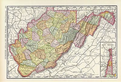
Maps of
West Virginia

3565087
|
Rand McNally and Company
Date: 1897
Short Title:
West Virginia.
|

4190000
|
Richardson, C.S.
Date: 1864
Short Title:
Richardson's Map Of West Virginia.
|

4975106
|
Hayes, Eli L.
Date: 1877
Short Title:
Point Pleasant, Mason Co., West Va. (with) West Columbia, Clifton, W. Va.
|

4975111
|
Hayes, Eli L.
Date: 1877
Short Title:
Huntington, Cabell Co., W. Va.
|

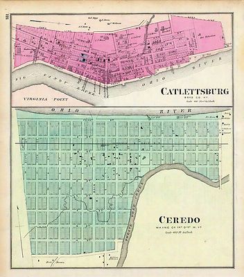
4975113
|
Hayes, Eli L.
Date: 1877
Short Title:
Ceredo, Wayne Co., 1st Dist., W. Va. (with) Catlettsburg, Boyd Co., Ky.
|

ar300700
|
Washington, George, 1732-1799.
Main Title: [Plat of a survey for William Hughes, Jr. of 460 acres in Frederick
County, Va. on the Cacapon River].
1750.
|

ct000363
|
Washington, George, 1732-1799.
Main Title: [Eight survey tracts along the Kanawha River, W.Va. showing land
granted to George Washington and others.
1774?]
|

ct000592
|
West Virginia Geological Survey.
Main Title: Soil map : West Virginia, Boone county sheet.
Baltimore : A. Hoen & Co., 1913.
|

ct000593
|
Swann, John S.
Main Title: Title map of the coal field of the great Kanawha Valley.
New York : G.W. & C.B. Colton, 1867.
|

ct000594
|
Hotchkiss, Jedediah, 1828-1899.
Main Title: Map of Great Kanawha coal field showing location of mines.
[Staunton, Va.], 1886.
|

ct000595
|
Chesapeake and Ohio Railroad Company.
Main Title: General and regional map of that portion of the New River and
Kanawha coal fields lying between the New, Kanawha and Guyandot Rivers and
west of Piney Creek.
New York : Julius Bien & Co., c1905.
|

ct000776
|
United States. Post Office Dept.
Main Title: Post route map of the state of Virginia and West Virginia.
[Washington, D.C.] : Postmaster General, 1896.
|

cw0481700
|
Nicholson, W. L.
Main Title: Map of the state of Virginia / compiled from the best authorities,
at the Coast Survey Office. A. D. Bache, Supdt. August 1863. Compiled by
W. L. Nicholson. Lith. by Chas. G. Krebs.
[Washington] : U.S. Coast Survey , 1863.
|

cw0493600
|
Nicholson, W. L.
Main Title: Map of the State of Virginia compiled from the best authorities,
and printed at the Coast Survey Office. A. D. Bache, Supdt. May 1864. Compiled
by W. L. Nicholson.
[S.l.], Lith. by Chas. G. Krebs., 1864.
|

cw0509200
|
Nicholson, W. L.
Main Title: Map of the State of Virginia compiled from the best authorities,
and printed at the Coast Survey Office. A. D. Bache, Supdt. 1865. Compiled
by W. L. Nicholson. Lith. by Chas. G. Krebs.
[S.l.], 1865.
|

cw0509400
|
Northrup, William P.
Main Title: Map of Virginia and neighboring states showing the location of
battles in the Civil War 1861-1865.
|

cw0693000
|
Richardson, James H.
Main Title: Map to illustrate the report of Brigadier-General Hill Richardson,
sc.
N.Y., [1861]
|

cw0694000
|
United States. Army. Corps of Engineers.
Main Title: Map of the battle field of Carnifex Ferry, Gauley River, West
Va., Sept. 10th 1861. United States forces commanded by Brig. Gen. W. S.
Rosecrans Published by authority of the Hon. the Secretary of War.
[S.l.], Office of the Chief of Engineers, U.S.A., 1876.
|

cwh00043
|
[Map of Loudoun County and part of Clarke County, Va., Jefferson County
and part of Berkeley County, W. Va., and parts of Montgomery and Frederick
counties, Md.].
[1864]
|

cwh00066
|
[Sketch of western Virginia and eastern West Virginia, between Staunton
and Clarksburg].
[1861]
|

cwh00068
|
[Map of portions of Hampshire and Mineral Counties, W. Va., and Garrett
County, Md.].
[1861]
|

cwh00081
|
[Pencil sketch of the road from Slaven’s Cabin to the top of Cheat
Mountain in the area of the battle of Rich Mountain, July 11-12, 1861]. |

cwh00084
|
[Sketch of roads and streams in Highland County, Va., and Pendleton County,
W. Va.].
[1861]
|

cwh00184
|
[Sketch of the region west of Charlestown, West Virginia, showing
fortifications].
[1864]
|

cwh00191
|
[Topographic map of the vicinity of Harpers Ferry, West Virginia].
[1864]
|

cwh00192
|
Vicinity of Harpers Ferry.
[1864]
|

cwh00214
|
Hotchkiss, Jedediah, 1828-1899.
Main Title: A centennial map of the Lexington Presbytery of the Synod of
Virginia of the Presbyterian Church in the United States, organized Sept.
26, 1786, centennial Sept. 26, 1886, at Timber Ridge Church / by Jed. Hotchkiss,
Top. Eng.
|

cwh00216
|
[Sketch of central West Virginia, showing drainage between Clarksburg
and Charleston].
[187-?]
|

cwh00217
|
Hotchkiss, Jedediah, 1828-1899.
Main Title: Plats of the Wilson Cary Nicholas surveys (from the originals)
made in Wythe and Russell Counties, Virginia, now Mercer, Raleigh, Wyoming,
McDowell, and Logan counties, West Virginia / Eng. Office of Jed. Hotchkiss,
Staunton, Va., July 1st, 1884
|

cwh00218
|
Rogers, William Barton, 1804-1882.
Main Title: Geological map of Virginia & West Virginia showing their
chief geological sub-divisions / by Prof. William B. Rogers on basis of the
physical & pol. map of A. Guyot.
[S.l. : s.n., 187-?]
|

cwh00220
|
Hotchkiss, Jedediah, 1828-1899.
Main Title: Geological map of the Potomac basin west of Blue Ridge, Virginia
and West Virginia : showing the relations of its upper Potomac coal basin
and the iron-ore bearing areas in reference to the West Virginia Central
and Pittsburg [sic] R.R., and its connections and extensions / compiled from
surveys by W.B. Rogers and others by Jed. Hotchkiss, Consulting Eng., etc.
1882.
|

cwh00227
|
Ruffner, W. H.
Main Title: From Cold Mt. in Amherst across Rockbridge & Bath cos., Va.
& part of Pocahontas Co., W. Va. / surveyed by Dr. W.H. Ruffner &
Prof. J.L. Campbell (1861-77) ; drawn by Prof. C.
|

cwh00238
|
Hotchkiss, Jedediah, 1828-1899.
Main Title: Map of part of the great Flat-top coal-field of Va. & W.
Va. showing location of Pocahontas & Bluestone collieries, May 1886 /
Eng. Office of Jed. Hotchkiss, Staunton, Va.
|

cwh00239
|
Hotchkiss, Jedediah, 1828-1899.
Main Title: Coal section of Flat-top Mountain / Jed. Hotchkiss, Staunton,
Va., 1896.
|

cwh00240
|
Hotchkiss, Jedediah, 1828-1899.
Main Title: Section of coal beds in Flat-top Mountain / Jed. Hotchkiss, Staunton,
Va., 1896.
|

cwh00251
|
Hotchkiss, Jedediah, 1828-1899.
Main Title: Topographical map of the Cabin Creek coal lands, situated in
Boone and Kanawha counties, West Virginia : containing 15,532 acres / from
surveys by M.A. Miller ; Engineer Office, Jed. Hotchkiss, Staunton, Va.
[188-?]
|

cwh00252
|
Miller, M. A.
Main Title: A topographical map of the lands of the Cabin Creek Coal Co.
of W. Virginia embracing 14,307 acres in Kanawha and Boone counties, West
Virginia / from actual surveys by M.A. Miller, 1873.
|

cwh00253a
|
Dr. Hale’s map of Cabin Creek lands.
[1893]
|

cwh00253b
|
Hale’s 8225 A Cabin Cr.
[1893]
|

cwh00254
|
Map showing location of Flat top, New River, Gauly Lower Measures coal
field, West Virginia.
[188-?]
|

cwh00256
|
Hotchkiss, Jedediah, 1828-1899.
Main Title: Map of the Loup-Piney Divide coal lands in Fayette and Raleigh
cos., West Virginia / Eng. Office of Jed. Hotchkiss, Cons. Eng., Staunton,
Va., Nov. 1879.
|

cwh00257
|
Hotchkiss, Jedediah, 1828-1899.
Main Title: Map of the Loup-Piney Divide coal lands in Fayette and Raleigh
cos., West Virginia / Eng. Office of Jed. Hotchkiss, Staunton, Va., Oct.
25th, 1879.
|

cwh00258
|
[Survey of a tract of 9,138 acres of coal lands on the New River in Raleigh
County, West Virginia, west of Quinnimont].
[188-?]
|

cwh00259
|
Hotchkiss, Jedediah, 1828-1899.
Main Title: Map of the New River Coalfield on C.& O. R.R. / by Jed.
Hotchkiss, C.E.
[188-?]
|

cwh00261
|
Hotchkiss, Jedediah, 1828-1899.
Main Title: Map showing location &c. of "Middleton" coal lands, Fayette
County, W. Va. / from surveys by County Surveryor [sic.] Settle, Eng. Office
of Jed. Hotchkiss, Staunton, Va. Feb. 1882.
|

cwh00262
|
Reddy, Walter Comfort, b. 1870.
Main Title: Map showing land holdings in Muddlety Cr. Coal Field in Nicholas
Co., W. Va. / W.C. Reddy, C.E., Nicholas C.H., W. Va., Feby 25, 1895.
|

cwh00263
|
Hotchkiss, Jedediah, 1828-1899.
Main Title: Map of the "Slaughter’s Creek" coal & timber lands,
2,907 acres, Kanawha County, West Virginia, U.S. America / Engineer Office
of Jed. Hotchkiss, Staunton, Virginia, Jan. 1875.
|

cwh00269
|
Oltmanns, C. W.
Main Title: [Map of Royal Land Company of Virginia lands in Rockingham, and
Augusta counties Virginia, and Pendleton County, West Virginia] / Office,
Royal Land Company of Virginia, Jan. 1877, C.W. Oltmanns C.E., Harrisonburg,
Va.
|

cwh00272
|
[Sketch of the "proposed route of Virginias Railway" to Flat-top and
Guyandot coal fields, West Virginia].
[188-]
|

cwh00309
|
[Rough sketch of roads and streams in Pocahontas and Greenbrier counties,
West Virginia].
[187-?]
|

cwh00320
|
Tract no. 1, plat of Wm. T. Mann, 1,147 A. patent : according to patent
calls, corrected by lat. & dep.
[187-?]
|

cwh00322
|
Hotchkiss, Jedediah, 1828-1899.
Main Title: Map showing the location of the "Herr" lands, Grant County, W.
Va. / compiled from 1855 map of W. Va. C. & Pg. Ry., by Jed. Hotchkiss,
Cons. Eng., Staunton, Va., May 1892.
|

cwh00323
|
Sketch map showing location of 5,007 acres of Elkhorn Fork, W. Va. coal
& timber lands.
[187-?]
|

cwh00327
|
Plat of the partition of Moore & Beckley survey of 170,038 a. in
the counties of Giles & Logan, Virginia.
[187-?]
|

cwh00336
|
Map of Huntington, W. Va., and vicinity, the Ohio River terminus of the
Virginias Railway.
[188-?]
|

cwh00337
|
Hotchkiss, Jedediah, 1828-1899.
Main Title: Map of the "Kanawha City" estates, Kanawha County, West Virginia,
United States of America / Engineer Office of Jed. Hotchkiss, Staunton, Virginia,
Jan. 1875.
|

cws00179
|
[Map of part of Pocahontas, Randolph, and Webster counties, West Virginia].
[1865?]
|

lva00026
|
Johnson's Virginia, Delaware, Maryland & West Virginia.
New York : A.J. Johnson, 1864. |

lva00078
|
Map showing the location of railroads, canals, navigation projects and
public institutions in which the Commonwealth of Virginia had invested money
as of date January 1st. 1861 : as traced from an official map in the possession
of the Virginia State Library entittled [sic] "A map of the State of Virginia
reduced from the Nine Sheet Map of the State in conformity to law by Herman
Boye, 1828, corrected by order of the Executive 1859 by L.v. Buckholtz" :
together with the division line later established between Virginia and West
Virginia and additional extensions made from completion of map until January
1st, 1861.
[S.l. : s.n., 1914?]
|

lva00089
|
New map of Virginia : compiled from the latest maps / drawn and colored
by Husted & Nenning ; lith. of Hoyer & Ludwig.
Husted & Nenning.
Richmond, Va. : J.W. Randolph, Publisher, 1861.
|

lva00095
|
County map of Virginia and West Virginia / drawn & engd. W.H. Gamble.
Mitchell, S. Augustus 1792-1868. (Samuel Augustus),
[Philadelphia?] : S.A. Mitchell, c1863.
|

lva00096
|
Johnson's Virginia, Delaware, Maryland & West Virginia.
Johnson, A. J. 1827-1884. (Alvin Jewett),
[New York] : Johnson and Ward, 1864.
|

lva00119
|
Johnson's Virginia, Delaware and Maryland.
Johnson, A. J. 1827-1884. (Alvin Jewett),
[New York] : Johnson and Ward, [1864]
|

lva00131
|
[Map of Raleigh, Mercer and Summers Counties, West Virginia / prepared
by residents of western Virginia for General Loring]
[1862?]
|

pm006800
|
Wellge, H. (Henry).
Main Title: Bird’s eye view of Bellaire, Ohio 1882. H. Wellge, del.
Beck & Pauli, lithographers.
Madison, Wis., J. J. Stoner, c1882.
|

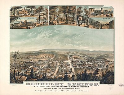
pm009860
|
Moray, John, 1831-
Main Title: Berkeley Springs, a celebrated and fashionable health resort,
county seat of Morgan Co., W.Va. A. Hoen & Co., lith.
Baltimore, c1889.
|

pm009870
|
Fowler, T. M. (Thaddeus Mortimer), 1842-1922.
Main Title: Aero view of Bluefield, West Virginia 1911 / T. M. Fowler del.
Flemington, N.J. : Fowler & Basham, 1911.
|

pm009880
|
Fowler, T. M. (Thaddeus Mortimer), 1842-1922.
Main Title: Buckhannon, West Virginia 1900. Drawn by T. M. Fowler.
Morrisville, Pa., T. M. Fowler & James B. Moyer [1900]
|

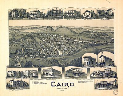
pm009881
|
Fowler, T. M. (Thaddeus Mortimer), 1842-1922.
Main Title: Cairo, West Virginia 1899. Drawn by T. M. Fowler.
Morrisville, Pa., T. M. Fowler & James B. Moyer [1899]
|

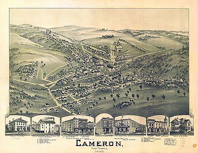
pm009891
|
Fowler, T. M. (Thaddeus Mortimer), 1842-1922.
Main Title: Cameron, West Virginia 1899. Drawn & published by T. M. Fowler.
Wheeling News Lith.
Morrisville, Pa. [1899]
|

pm009901
|
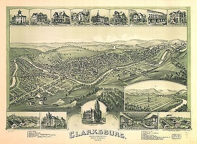
Fowler, T. M. (Thaddeus Mortimer), 1842-1922.
Main Title: Clarksburg, West Virginia 1898. Drawn by T. M. Fowler.
Morrisville, Pa., T. M. Fowler & James B. Moyer [1898]
|

pm009920
|
Fowler, T. M. (Thaddeus Mortimer), 1842-1922.
Main Title: Davis, Tucker County, West Virginia 1898. Drawn by T. M. Fowler.
Morrisville, Pa. [1898]
|

pm009930
|
Fowler, T. M. (Thaddeus Mortimer), 1842-1922.
Main Title: Elkins, Randolph County, W.Va. 1897. Drawn by T. M. Fowler.
Morrisville, Pa., T. M. Fowler & James B. Moyer [1897]
|

pm009931
|
Fowler, T. M. (Thaddeus Mortimer), 1842-1922.
Main Title: Fairmont and Palatine, West Virginia 1897. Drawn by T. M. Fowler.
Morrisville, Pa., T. M. Fowler & James B. Moyer [1897]
|

pm009950
|
Downs, A. E. (Albert E.)
Main Title: Grafton, West Virginia 1898. Drawn by A. E. Downs. Copyrighted
by T. M. Fowler.
Boston, Fowler & Downs [1898]
|

pm009960
|
Fowler, T. M. (Thaddeus Mortimer), 1842-1922.
Main Title: Harrisville, Ritchie County, W.Va. 1899. Drawn by T. M. Fowler.
Published/Created: Morrisville, Pa., T. M. Fowler & James B. Moyer [1899]
|

pm009980
|
Fowler, T. M. (Thaddeus Mortimer), 1842-1922.
Main Title: Aero view of Keystone, West Virginia 1911. Drawn and published
by T. M. Fowler.
Published/Created: Flemington, N.J. [1911]
|

pm009990
|
Fowler, T. M. (Thaddeus Mortimer), 1842-1922.
Main Title: Mannington, West Virginia 1897. Drawn by T. M. Fowler.
Published/Created: Morrisville, Pa., T. M. Fowler & James B. Moyer [1897]
|

pm010000
|
Fowler, T. M. (Thaddeus Mortimer), 1842-1922.
Main Title: Morgantown, West Virginia 1897. Drawn by T. M. Fowler.
Published/Created: Morrisville, Pa., T. M. Fowler & James B. Moyer [1897]
|

pm010001
|
Downs, A. E. (Albert E.)
Main Title: Moundsville, West Virginia 1899. Drawn by A. E. Downs.
Published/Created: Myerstown, Pa., James B. Moyer [1899]
|

pm010020
|
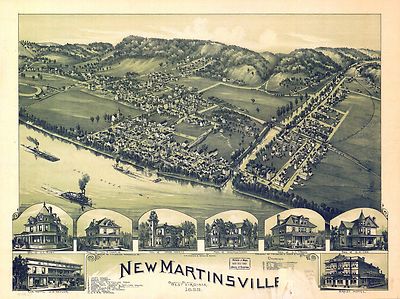
Fowler, T. M. (Thaddeus Mortimer), 1842-1922.
Main Title: New Martinsville, West Virginia 1899. Drawn by T. M. Fowler.
Published/Created: Morrisville, Pa., T. M. Fowler & James B. Moyer [1899]
|

pm010030
|
Fowler, T. M. (Thaddeus Mortimer), 1842-1922.
Main Title: Aero view of North Fork and town of Clark, West Virginia 1911.
Drawn and published by T. M. Fowler.
Published/Created: Flemington, N.J. [1911]
|

pm010040
|
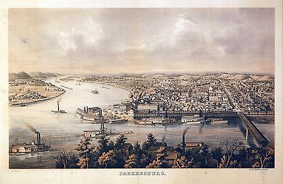
A. Hoen & Co.
Main Title: Parkersburg.
Published/Created: Baltimore [1861?]
|

pm010050
|
Fowler, T. M. (Thaddeus Mortimer), 1842-1922.
Main Title: Parkersburg, West Virginia 1899. Drawn by T. M. Fowler.
Published/Created: Morrisville, Pa., T. M. Fowler & James B. Moyer [1899]
|

pm010060
|
Fowler & Kelly.
Main Title: View of Parsons, West Virginia 1905. Drawn and published by Fowler
& Kelly. Copyrighted by Thaddeus M. Fowler.
Published/Created: Morrisville, Pa. [1905]
|

pm010061
|
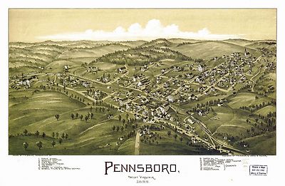
Fowler, T. M. (Thaddeus Mortimer), 1842-1922.
Main Title: Pennsboro, West Virginia 1899. Drawn by T. M. Fowler.
Published/Created: Morrisville, Pa., T. M. Fowler & James B. Moyer [1899]
|

pm010080
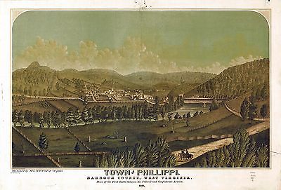
|
Pool, M. D., Mrs.
Main Title: Town of Phillippi, Barbour County, West Virginia. 1861. Sketched
by Mrs. M. D. Pool of Virginia.
Published/Created: [n.p., 1861]
|

pm010090
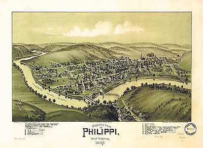
|
Fowler, T. M. (Thaddeus Mortimer), 1842-1922.
Main Title: Bird’s eye view of Philippi, West Virginia 1897. Drawn by
T. M. Fowler.
Published/Created: Morrisville, Pa., T. M. Fowler & James B. Moyer [1897]
|

pm010100
|
Fowler, T. M. (Thaddeus Mortimer), 1842-1922.
Main Title: St. Mary’s, West Virginia 1899. Drawn by T. M. Fowler.
Published/Created: Morrisville, Pa., T. M. Fowler & James B. Moyer [1899]
|

pm010110
|
Fowler, T. M. (Thaddeus Mortimer), 1842-1922.
Main Title: Salem, West Virginia 1899. Drawn by T. M. Fowler.
Published/Created: Morrisville, Pa., T. M. Fowler & James B. Moyer [1899]
|

pm010111
|
Fowler, T. M. (Thaddeus Mortimer), 1842-1922.
Main Title: Sistersville, West Virginia 1896. Drawn by T. M. Fowler.
Published/Created: Morrisville, Pa., T. M. Fowler & James B. Moyer [1896]
|

pm010140
|
Fowler, T. M. (Thaddeus Mortimer), 1842-1922.
Main Title: Weston, West Virginia 1900. Drawn by T. M. Fowler.
Published/Created: Morrisville, Pa., T. M. Fowler & James B. Moyer [1900]
|

pm010160
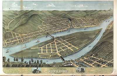
|
[Ruger, A.]
Main Title: Bird’s eye view of the city of Wheeling, West Virginia 1870.
Chicago Lithographing Co.
Published/Created: Madison, Wis., Ruger & Stoner [1870]
|

rr003120
|
Rand McNally and Company.
Main Title: Indexed county and railroad pocket map and shippers guide of
West Virginia, accompanied by a new and original compilation and ready reference
index, showing in detail the entire railroad system.
Published/Created: Chicago, 1898.
|

rr003650
|
Maury, Matthew Fontaine, 1849-1886.
Main Title: Map showing the economic minerals along the route of the Chesapeake
& Ohio Rail Way to accompany the geological report of Thomas S. Ridgway.
Published/Created: [n.p.], 1872.
|

rr004800
|
Hotchkiss, Jedediah, 1828-1899.
Main Title: Route of the New River R.R., 188-.
Published/Created: [188-]
|

rr005400
|
G.W. & C.B. Colton & Co.
Main Title: Map showing the projected route of the Potomac and Ohio Railway.
Published/Created: New York, 1874.
|

rr006030
|
G.W. & C.B. Colton & Co.
Main Title: Map of the Virginia, Kentucky, and Ohio Railroad connecting the
railroads of Virginia with the railroads of Kentucky on the shortest route
east and west from the Mississippi Valley to the Atlantic Ocean.
Published/Created: New York, 1881.
|

0027008
|

0041008
|

0186002
|

0209002
|

0358031
|

0535023
|

0579024
|

0586020
|

0592023
|

0594022
|

0747003
|

1071005
|

2054027
|

2094025
|

2134062
|

2483020
|

2809018
|

2809019
|

2809021
|

2844031
|

3888024
|

3940002
|

4324017
|

4520034
|

4555002
|

4574021
|

4727014
|

4727015
|

4727016
|

4727017
|

4825035
|

4977018
|

4986001
|

5028049
|

5028050
|

5041013
|

5139003
|

5198020
|

5370003
|

5371121
|

5747018
|

6727019
|
|