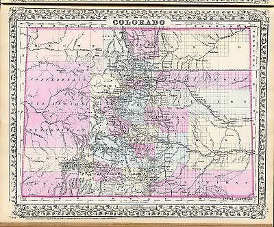
Maps of
Colorado

0041033
|
Asher & Adams
1874
Colorado.
|

0586044
|
Mitchell, Samuel Augustus
1880
Colorado.
|

0594044
|
(Mitchell, Samuel Augustus)
1890
Colorado.
|

0662001
|
Nell, Louis
1884
Map of the State of Colorado.
|

1070016
|
U.S. General Land Office
1866
Colorado Territory.
|

2212253
|
Vandermaelen, Philippe, 1795-1869; Delavault, A.
1827
Parties, Etats-Unis et Nouv. Mexique. Amer. Sep. 48.
|

2719169
|
Everts & Kirk
1885
Denver Junction.
|

2738037
|
Wheeler, G.M.
1879
52D. Part Of Central Colorado.
|

2738038
|
Wheeler, G.M.
1879
52D. Land Classification Map Of Part Of Central Colorado.
|

2738039
|
Wheeler, G.M.
1877
53C. Part Of Central Colorado.
|

2738049
|
Wheeler, G.M.
1877
61A. Parts Of Southwestern Colorado.
|

2738050
|
Wheeler, G.M.
1879
61B. Central Colorado.
|

2738051
|
Wheeler, G.M.
1876
61B. Economical Features Of Central Colorado.
|

2738052
|
Wheeler, G.M.
1875
61C. SW Colorado.
|

2738053
|
Wheeler, G.M.
1878
61C. Part Of Southwestern Colorado.
|

2738054
|
Wheeler, G.M.
1878
61C. Land Classification Map Of Part Of South Western Colorado.
|

2738055
|
Wheeler, G.M.
1876
61C. S.W. Colorado, San Juan Mining Region.
|

2738056
|
Wheeler, G.M.
1877
61C. Economical Features Of S.W. Colorado, San Juan Mining Region.
|

2738057
|
Wheeler, G.M.
1878
61D. Part Of South Western Colorado.
|

2738058
|
Wheeler, G.M.
1879
61D. Land Classification Map Of Part Of South Western Colorado.
|

2738059
|
Wheeler, G.M.
1878
62A. Central Colorado.
|

2738060
|
Wheeler, G.M.
1878
62A. Land Classification Map Of Part Of Central Colorado.
|

2738061
|
Wheeler, G.M.
1878
62C. Part Of Southern Colorado.
|

2738062
|
Wheeler, G.M.
1878
62C. Land Classification Map Of Part Of Southern Colorado.
|

2738063
|
Wheeler, G.M.
1882
62D. Part of South Eastern Colorado.
|

2738070
|
Wheeler, G.M.
1882
69. Parts Of Southern Colorado And Northern New Mexico.
|
|
|

2738071
|
Wheeler, G.M.
1878
69B. Parts Of South'n Colorado & North'n New Mexico.
|

2738072
|
Wheeler, G.M.
1878
69B. Economic Features Of Parts Of South'n Colorado & North'n New Mexico.
|

2738076
|
Wheeler, G.M.
1877
70A. Parts Of Southern Colorado And Northern New Mexico.
|

2738077
|
Wheeler, G.M.
1877
70A. Economic Features Of Parts Of Southern Colorado And Northern New Mexico.
|

2738078
|
Wheeler, G.M.
1881
70A. Parts Of Southern Colorado And Northern New Mexico.
|

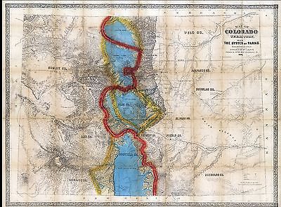
3509001
|
Ebert, Frederick J. ; Gilpin, William, 1822-1894 ; Monk, Jacob
1865
Map Of Colorado Territory, Shewing The System Of Parks.
|

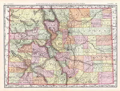
3565143
|
Rand McNally and Company
1897
Colorado.
|

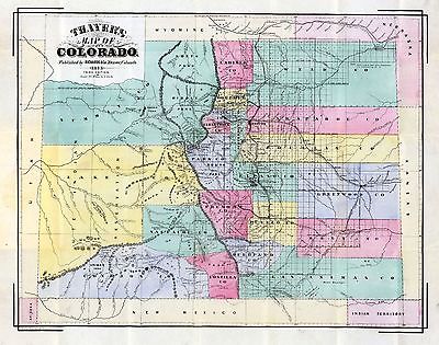
3702001
|
Thayer, H.L.
1873
Thayer's Map Of Colorado.
|

4428001
|
Adams, George H. & Son
1887
Colorado.
|

4520039
|
Rand McNally and Company
1879
Colorado.
|

4576001
|
Hayden, F.V.
1881
Triangulation Map of Colorado.
|

4576002
|
Hayden, F.V.
1881
Drainage Map of Colorado.
|

4576003
|
Hayden, F.V.
1881
Economic Map of Colorado.
|

4576004
|
Hayden, F.V.
1881
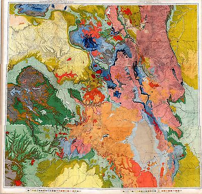
General Geological Map of Colorado.
|

4576005
|
Hayden, F.V.
1881
North-western Colorado and part of Utah.
|

4576006
|
Hayden, F.V.
1881
Northern Central Colorado.
|

4576008
|
Hayden, F.V.
1881
Western Colorado and Part of Utah.
|

4576009
|
Hayden, F.V.
1881
SW. Colorado and Parts of New Mexico, Arizona and Utah.
|

4576010
|
Hayden, F.V.
1881
Southern Central Colorado and Part of New Mexico.
|

4576011
|
Hayden, F.V.
1881
Composite: Colorado. V-X.
|

4576012
|
Hayden, F.V.
1881
North-western Colorado and part of Utah.
|

4576013
|
Hayden, F.V.
1881
Northern Central Colorado.
|

4576014
|
Hayden, F.V.
1881
Central Colorado.
|

4576015
|
Hayden, F.V.
1881
Western Colorado and Part of Utah.
|

4576016
|
Hayden, F.V.
1881
SW. Colorado and Parts of New Mexico, Arizona and Utah.
|

4576018
|
Hayden, F.V.
1881
Composite: Colorado. XI-XVI.
|

4787001
|
Thayer, H.L ; Rollandet, Edward
1880
Thayer's New Map Of The State of Colorado.
|

4788001
|
Rand McNally and Company
1879
Rand, McNally & Co.'s new geological map of Colorado.
|

4841001
|
Thayer, H.L.
1879
Thayer's Map of Denver Colorado.
|

5370028
|
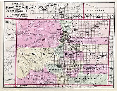
Cram Atlas Company
1875
Colorado.
|

5447000
|
U.S. General Land Office
1879
State of Colorado.
|

ct000610
|
Pezolt, F. (Frank)
Colorado / Caxton Co. ; drawn & lith. by F. Pezolt.
Denver, James McConnell 1894
|

ct001031
|
Ebert, Frederick J.
Map of Colorado Territory embracing the Central Gold Region / drawn by Frederick
J. Ebert ; under direction of the Governor Wm. Gilpin.
Philadelphia : Jacob Monk, 1862
|

np000054
|
Stanton, Robert Brewster, 1846-1922.
Diagram showing the history of the exploration and navigation and survey
of the Grand and other canons of the Colorado River of the West from 1540
to 1908.
[S.l.], 1908.
|

np000062
|
Ives, J. C.
Rio Colorado of the West / explored by 1st. Lieut. Joseph C. Ives, Topl.
Engrs. under the direction of the Office of Explorations and Surveys, A.
A. Humphreys, Capt. Topl. Engrs. in charge, by order of the Hon. John B.
Floyd, Secretary of War ; drawn by Frhr. F. W. v. Egloffstein, topographer
to the expedition.
[Washington] : Office of Explorations and Surveys, 1858.
|

np000095
|
Underwood & Underwood.
Grand Canyon of the Colorado.
[S.l] 1904
|

pm000532
|
Koch, Augustus, b. 1840.
Bird’s eye view of Aspen, Pitkin Co., Colo. 1893.
[Aspen] Aspen times [1893]
|

pm000540
|
Stoner, J. J.
Black Hawk, Colo. 1882. Beck & Pauli, lithographers.
Madison, Wis., c1882.
|

pm000550
|
Stoner, J. J.
Bird’s eye view of Buena Vista, Colo. county seat of Chaffee County.
1882. Beck & Pauli, lithographers.
Madison, Wis., c1882
|

pm000560
|
Wellge, H. (Henry)
Bird’s eye view of Canon City, Colo. county seat of Fremont County 1882.
[By] H. Wellge. Beck & Pauli, lithographers.
Madison, Wis., J. J. Stoner, c1882.
|

pm000570
|
Kohfahl, John.
Map of great western Central City. Robert A. Welcke, photo-lith.
N[ew] Y[ork] c1887.
|

pm000580
|
Stoner, J. J.
Panoramic bird’s eye view of Colorado Springs, Colorado City and Manitou,
Colo. 1882. Beck & Pauli, lithographers.
Madison, Wis., c1882.
|

pm000582
|
[Wellge, H. (Henry)]
Pikes Peak panorama.
Milwaukee, Wis., American Publishing Co. [1890]
|

pm000590
|
Benford-Bryan Pub. Co.
Bird’s-eye-view of Colorado Springs, Colorado.
Denver, c1909.
|

pm000591
|
Amerine, C. H.
Cripple Creek mining district, the great gold camp of Colorado / bird’s
eye view by C.H. Amerine ; compliments of the Cripple Creek Sunday Herald.
Edition Information: Souvenir ed., 1895.
|

pm000600
|
Phillips & Desjardins.
Cripple Creek, 1896.
Denver, Western Litho. Co., c1896.
|

pm000630
|
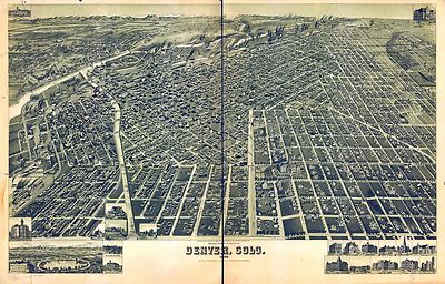
Flett, J. H.
Bird’s eye view of the city of Denver, Colorado, 1881. Drawn by J. H.
Flett.
[n.p., 1881]
|

pm000640
|
Rocky Mountain News, Denver.
Bird’s-eye view of Denver, 1887.
|

pm000650
|
Wellge, H. (Henry)
Perspective map of the city of Denver, Colo. 1889. H. Wellge, des.
Milwaukee, American Publishing Co. [1889]
|

pm000651
|
Mitchell, Andrew E.
Birdseye view from South Broadway ... showing Harlem, Jacksons Broadway Heights
& city of Denver. [Signed:] A. E. Mitchell. Denver Engraving Co. A. F.
Haraszthy, W. J. Voit with Colorado Land Headquarters.
Denver, c1907.
|

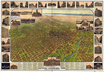
pm000660
|
Birdseye View Publishing Co.
Bird’s eye view of Denver, Colorado, 1908. Denver Lith. Co.
Denver [1908] c1907.
|

pm000661
|
Houghton, Merritt Dana.
[Fort Collins, Colorado. M. D.] Hought[on.
n.p., 1865?]
|

pm000670
|
Houghton, Merritt Dana.
[Fort Collins, Colorado] Drawn by M. D. Houghton.
[n.p.] 1899.
|

pm000680
|
Stoner, J. J.
Bird’s eye view of Golden, Colo. co. seat of Jefferson County, 1882.
Beck & Pauli, lithographers.
Madison, Wis., c1882.
|

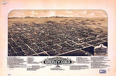
pm000690
|
Stoner, J. J.
Bird’s eye view of Greeley, Colo. county seat of Weld Co. 1882. Beck
& Pauli, lithographers.
Madison, Wis., c1882.
|

pm000700
|
Stoner, J. J.
Bird’s eye view of Gunnison, Colo. county seat of Gunnison County, 1882.
Beck & Pauli, lithographers.
Madison, Wis., c1882.
|

pm000710
|
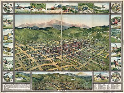
Koch, Augustus, b. 1840.
Bird’s eye view of Leadville, Lake County, Colo. 1879.
Kansas City, Mo., Ramsey, Millet & Hudson, litho., c1879.
|

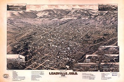
pm000720
|
Wellge, H. (Henry)
Bird’s eye view of Leadville, Colo. 1882. H. Wellge, del. Beck &
Pauli, lithographers.
Madison, Wis., J. J. Stoner, c1882
|

pm000730
|
Stoner, J. J.
Bird’s eye view of Maysville, Colo. Chaffee County 1882. Beck &
Pauli, lithographers.
Madison, Wis., c1882.
|

pm000740
|
American Publishing Co. (Milwaukee, Wis.)
Pueblo, Colo. 1890.
|

pm000750
|
Stoner, J. J.
Bird’s eye view of Salida, Chaffee County, Colorado. 1882. Beck &
Pauli, lithographers.
|

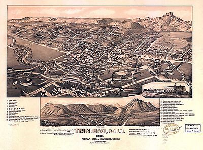
pm000760
|
Stoner, J. J.
Trinidad, Colo. 1882 county seat of Las Animas County. Beck & Pauli,
lithographers.
|

rr001900
|
Rand McNally and Company.
Indexed map of Colorado showing the railroads in the state, and the express
company doing business over each, also counties and rivers.
Chicago, 1879.
|

rr002210
|
Du Bois, Charles.
A new sectional map of the state of Kansas showing the route of the Union
Pacific Railway--E. D. to Denver City. Col. and complete system of projected
rail roads. Information compiled & collected from departments of the
government at Washington, D.C. and other authentic sources by W. J. Keeler,
C. E. 1867.
|

rr003600
|
G.W. & C.B. Colton & Co.
Map showing the California and Nevada Railroad and its extensions and
connections.
New York, 1882.
|

rr003980
|
Mota, Alb von.
Map of the Denver and Rio Grande Railway and connections.
[n.p., 1873]
|

rr003990
|
Eccles, S. W.
Map of the Denver & Rio Grande Railway, showing its connections and
extensions also the relative position of Denver and Pueblo to all the principal
towns and mining regions of Colorado and New Mexico.
Chicago, c1881.
|

rr004000
|
Rand McNally and Company.
Denver and Rio Grande Railway System, 1886.
[Chicago, 1886]
|

rr005110
|
Williams, Henry T.
New trans-continental map of the Pacific R.R. and routes of overland travel
to Colorado, Nebraska, the Black Hills, Utah, Idaho, Nevada, Montana, California
and the Pacific Coast.
[n.p.], c1877.
|

0027007
|

0151062
|

0152064
|

0164002
|

0352041
|

0579040
|

0592046
|

0664002
|

0665003
|

0753000
|

0755000
|

1012076
|

1071013
|

1550061
|

2054051
|

2134084
|

2142007
|

2212252
|

2266000
|

2307024
|

2483036
|

2699008
|

2699009
|

2699010
|

2699014
|

2844074
|

2861015
|

2871023
|

3039001
|

3054012
|

3054013
|

3057002
|

3379003
|

3380003
|

3439002
|

4576017
|

4587064
|

4727029
|

4977064
|

5028127
|

5203001
|

5204003
|

5755033
|

5784043
|

5802005
|
|