[Mount Desert Island and neighboring coast of Maine. Joseph Frederick
Wallet)1722-1824. London, 1776?] |
 |
Maine. U.S. Coast and Geodetic Survey. 1875. MAP 1 |
 |
Maine. U.S. Coast and Geodetic Survey. 1875. MAP 2 |
 |
Maine. U.S. Coast and Geodetic Survey. 1875. MAP 3 |
 |
Maine. U.S. Coast and Geodetic Survey. 1875. MAP 4 |
 |
Maine. U.S. Coast and Geodetic Survey. 1875. MAP 5 |
 |
Maine. U.S. Coast and Geodetic Survey. 1875. MAP 6 |
 |
Maine. U.S. Coast and Geodetic Survey. 1875. MAP 7 |
 |
Maine. U.S. Coast and Geodetic Survey. 1875. MAP 8 |
 |
Maine. U.S. Coast and Geodetic Survey. 1875. MAP 9 |
 |
National Wetlands Inventory, [Maine]. 1979 |
 |
Coast of Maine from Rockland Harbor to Pemaquid Point.1776 |
 |
Map of the railroads of the state of Maine accompanying the report of
the railroad commissioners. 1899. |
 |
Map of Bar Harbor, Maine, 1904. |
 |
Map of Bar Harbor, Maine, 1896. |
 |
Plan of Bar Harbor Mount Desert Island, Maine. 1887. |
 |
Maine. Geological Survey (U.S.) 1922 Map 1 |
 |
Maine. Geological Survey (U.S.) 1922 Map 2 |
 |
Coast of Maine from Frenchman Bay to Mosquito Harbor. 1776 |
 |
Chart of the coast of Maine 1837 Map 1 |
 |
Chart of the coast of Maine 1837 Map 2 |
 |
Coast of Maine from Salter Island to Portland Head. 1776 |
 |
Path map of the Eastern part of Mount Desert Island Maine. 1911 |
 |
Coast of Maine showing Blue Hill Bay, Penobscot Bay, Belfast Bay, Islesboro
Island, Deer Island, and other islands. |
 |
Coast of Maine showing entrances of Blue Hill Bay, Isle of Haut Bay,
and Penobscot Bay, with Owls Head, Vinalhaven Island, Isle au Haut, and other
islands. |
 |
A map of the sources of the Chaudière, Penobscot, and Kennebec
rivers, by Montresore. 1761? |
 |
Coast of Maine showing entrances of Blue Hill Bay, Isle of Haut Bay,
and Penobscot Bay, with Owls Head, Vinalhaven Island, Isle au Haut, and other
islands. 1776? |
 |
Acadia National Park, Maine, official map and guide / National Park
Service, U.S. Department of the Interior. 1989. |
 |
Coast of Maine from Mosquito Head to Spurwink River. |
 |
Birds eye view of the villages of New Castle & Damariscotta, Lincoln
Co., Maine, 1878 |
 |
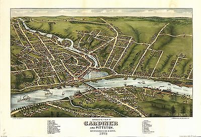
Bird's eye view of Gardiner and Pittston, Kennebec Co., Maine, 1878 |
 |
Plan of 50 townships to be sold by lottery lying between the rivers
Penobscot & Schoodic. |
 |
Map of Mount Desert Island, Maine. 1917 |
 |
Acadia National Park and vicinity, Hancock Co., Maine. 1971 |
 |
Maine, Hancock County, Acadia National Park and vicinity. 1935 |
 |
Topographic Map, Acadia National Park, Hancock County, Maine. 1931 |
 |
Map of Mount Desert Island. 1887 |
 |
Topographic map, Acadia National Park and vicinity, Hancock County,
Maine. 1956 |
 |
Dixfield, Maine, 1896. |
 |
Map of Mount Desert Island and the coast of Maine. |
 |
A Plan of the late Province of Main as far as Kennebeck River. 1778 |
 |
Historic resource study for the carriage road system, Acadia National
Park, Mount Desert Island, Maine / prepared for U.S. Department of the Interior,
National Park Service, North Atlantic Regional Office ; prepared by William
D. Rieley and Roxanne S. Brouse, Rieley & Associates, Landscape
Architects. |
 |
Bird's eye view of Eastport, Washington Co., Maine. |
 |
Presque Isle, Aroostook County, Maine. |
 |
Part of Oxford and Cumberland counties, Me. Drawn by S. Greenleaf. |
 |
Sieur de Monts National Monument, Mount Desert Island, Maine. |
 |
Sanford, Maine. Burleigh Lith. Est. 1889 |
 |
Livermore Falls, Maine. Burleigh Lith. Est. 1889 |
 |
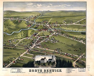
North Berwick, York Co., Maine 1877. |
 |
Pittsfield, Maine. Burleigh Lith. Est. 1889. |
 |
The above plan is a discription of a new township called Royalsborough
in the county of Cumberland, bounded southeasterly on the headline of Brunswick,
southwesterly on Northyarmouth, northwesterly on proprietors land, northeasterly
on Androscoggin River ... attest. Joseph Noyes, survayor. Deld. Falmouth,
May 22nd, 1766. |
 |
Blue Hill, Maine, 1896. |
 |
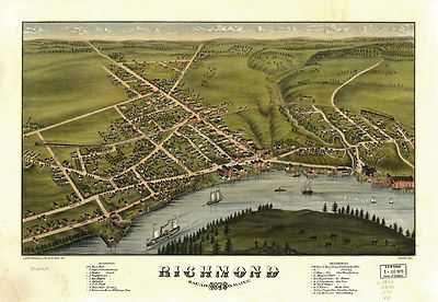
Richmond, Sagadahoc Co., Maine 1878. |
 |
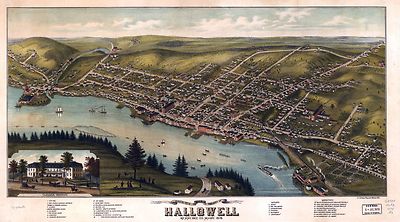
Bird's eye view of the city of Hallowell, Kennebec Co., Maine 1878 |
 |
Bird's eye view of the City of Bangor, Penobscot County, Maine, 1875
|
 |
Birds eye view of the village of Wiscasset, Lincoln Co., Maine, 1878 |
 |
Bar Harbor, Mt. Desert Island, Maine. Geo. H. Walker & Co. Lith. |
 |
South Berwick, York Co., Maine, 1877 / Jos. B.. Richards & Co. Lith.,
Boston, Mass. |
 |
Bridgton, Maine, U.S.A. : 1888 / the Burleigh Lith. Est. |
 |
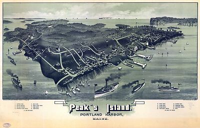
Peak's Island, Portland harbor, Maine. Geo. H. Walker & Co.
lith. |
 |
Monson, Maine. Drawn & published by Geo. E. Norris. The Burleigh
Lith. Est. 1889 |
 |
Guide map of Acadia National Park / United States Department of the
Interior, National Park Service. 1954 |
 |
Bird's eye view of the city of Portland, Maine 1876. Jos. Warner, artist.
Chas. Shober & Co. prop's Chicago Litho'g. Co. |
 |
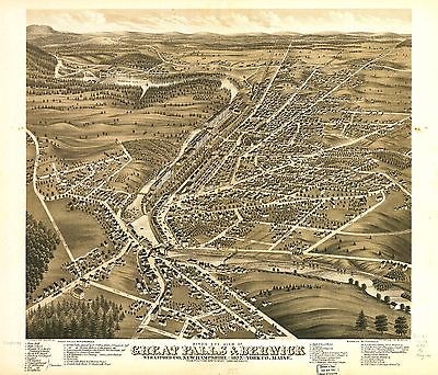
Bird's eye view of Great Falls, Strafford Co., New Hampshire & Berwick,
York Co., Maine 1877. A. Ruger del. C.H. Vogt & Co. Lith. |
 |
Monhegan, Me. 1886 |
 |
Houlton, Me. Aroostook County seat. |
 |
Wilton, Me. 1895 |
 |
Machias, Me., 1896 |
 |
Plan of Fort Pownal at Penobscot built 1759. |
 |
Kingfield, Me., Franklin Co., 1895. |
 |
A Map of 100 miles round Boston. 1775 |
 |
Map of the Portsmouth and Concord Railroad, shewing its connection with
other railroads. T. J. Carter, engineer. On stone by J. E. Moody. 1845 |
 |
The above plan is a discription of a new township containing the quantity
of seven and a half mile of land & water, granted by the General Court
to the proprietors of Bakerstown so call'd, lying & being in the county
of Cumberland ... Deld. at Falmouth, 4th September 1765. Attest. Joseph Noyes,
surveyr. |
 |
Penobscot River and Bay, with the operations of the English fleet, under
Sir George Collyer, against the division of Massachusetts troops acting against
Fort Castine, August 1779; with full soundings up to the present site of
Bangor. |
 |