Click Here. Double your traffic. Get Vendio Gallery - Now FREE!
Please title this page. (Page 1)
This CD is part of our Historic Atlas
and Map Collections.
We have dozens of Atlas maps on CD and DVD ranging from the 1500s
to the 1900s covering many areas and topics.
Please Check our Ebay Store for what's available. |
VERY LARGE HIGH RESOLUTION
MAP COLLECTION
ON DVD!!
(please see full table of contents and sample
illustrations below) |
|
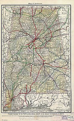
This DVD Contains 156 Maps of
Alabama
These are scans of the ORIGINAL
maps
on DVD
Features of this DVD
This auction is for a DVD -ROM of the maps
listed in electronic form,
NOT
the maps
themselves.
These maps are VERY high resolution and
can be printed at FULL SCALE or LARGER for framing and display. The results
are very high quality and convincing The files are in PDF format for easy
of viewing and printing.
Maps can be viewed and many scales and zoom
features are available as with any PDF file. |
Features of this DVD
This auction is for a DVD -ROM of the maps
listed in electronic form,
NOT
the maps
themselves.
These maps are VERY high resolution and
can be printed at FULL SCALE or LARGER for framing and display. The results
are very high quality and convincing.
For a sample map please:
CLICK
HERE
WARNING! This is
a LARGE file (5 Megabytes) if you are using
a slow connection it can take some time to load. |
|

0089032
|
Bradford, Thomas G.
1838
Alabama.
|

0104007
|
Burr, David H., 1803-1875
1839
Map of Georgia & Alabama.
|

0122025
|
Carey, H. C. ; Lea, I.
1822
Map Of Alabama.
|

0149037
|
Colton, G.W.
1856
Alabama.
|

0285022
|
Finley, Anthony
1831
Alabama.
|

0537023
|
Mitchell, Samuel Augustus
1846
New Map Of Alabama.
|

0565017
|
Mitchell, Samuel Augustus
1860
County Map Of Georgia, And Alabama.
|

0586024
|
Mitchell, Samuel Augustus
1880
Georgia, Alabama.
|

0594025
|
Mitchell, Samuel Augustus
1890
Georgia, Alabama.
|

0977019
|
Tanner, Henry S.
1836
New Map Of Alabama.
|

1070013
|
U.S. General Land Office
1866
Alabama.
|

2239029
|
Lloyd, H. H.
1873
Alabama, Arkansas, Louisiana, and Mississippi.
|

2301027
|
Morse, Sidney E. Sidney Edwards, 1794-1871; Breese, Samuel, 1802-1873
1845
Alabama.
|

2329009
|
Poussin, Guillaume Tell, 1794-1876
1834
Canal du Muscle-Shoal.
|

2483022
|
Mitchell, Samuel Augustus
1870
Georgia, Alabama.
|

2710034
|
Walling, H. F.; Gray, Ormando Willis; Lloyd, H. H.
1872
Alabama, Arkansas, Louisiana, and Mississippi.
|

2743005
|
Lange, Henry, 1821-1893.
1854
Alabama, Georgia, Sud Carolina und Florida.
|

3565096
|
Rand McNally and Company
1897
Alabama.
|

4453034
|
Goodrich, S.G. ; Bradford, Thomas G.
1841
Alabama.
|

4520030
|
Rand McNally and Company
1879
Alabama.
|

4584065
|
Lucas, Fielding Jr.
1823
Alabama.
|

4628053
|
Burr, David H., 1803-1875
1835
Map of the State of Alabama.
|

4664023
|
Collot, George Henri Victor ; Tardieu, P.F.
1796
Chart Of The Sources Of The Mobile.
|

4807153
|
Meyer, Joseph, 1796-1856
1845
Alabama.
|

4850053
|
Greenleaf, Jeremiah
1840
Map of the State of Alabama.
|

4966011
|
Hinton, John Howard); Hinton, Isaac Taylor, 1799-1847; Simpkin &
Marshall.
1831
Alabama, Georgia.
|

5370008
|
Cram Atlas Company
1875
Mississippi & Alabama.
|

5393001
|
Rand McNally and Company
1893
Map Of Alabama.
|

5449000
|
U.S. General Land Office
1878
State of Alabama.
|

ar164900
|
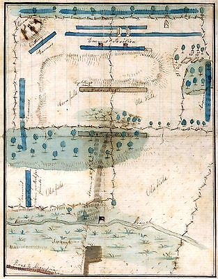
Taitt, David.
A plan of part of the rivers Tombecbe, Alabama, Tensa, Perdido, & Scambia
in the province of West Florida; with a sketch of the boundary between the
nation of upper Creek Indians and that part of the province which is contigious
thereto, as settled at the congresses at Pensacola in the years 1765 &
1771. Collected from different surveys at the desire of the Hon¯ble
John Stuart, Esquire, sole agent and superintendant of Indian Affairs for
the southern district of North America. By David Taitt.
[1771?]
|

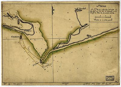
ar166900
|
Plano del Pto. de la Movila situado en la latd. N. de 30° 10' tomado
a´ los Ings., el di´a 14 de marzo de 1780.
[1780?]
|

ct000681
|
Demarigny.
Carte particulie`re d’une partie de la Louisianne ou les fleuve et rivierres
[i.e. rivie`res] onts ete´s releve´ a l’estime & les routtes
[i.e. routes] par terre releve´ & mesure´es aux pas, par les
Srs. Broutin, de Verge´s, inge´nieurs & Saucier dessinateur
/ Demarigny.
[1743]
|

cw0001700
|
Bachmann, John.
Birds eye view of Louisiana, Mississippi, Alabama and part of Florida Drawn
from nature and lith. by John Bachmann.
[New York] c1861.
|

cw0006600
|
Colton, J. H. (Joseph Hutchins), 1800-1893.
Colton’s map of the southern states. Including Maryland, Delaware, Virginia,
Kentucky, Tennessee, Missouri, North Carolina, South Carolina, Georgia, Alabama,
Mississippi, Arkansas, Louisiana, Texas. Showing also part of adjoining states
& territories locating the forts & military stations of the U. States
& showing all the rail roads, r. r. stations, & other internal
improvements.
New York J. H. Colton 1861.
|

cw0009000
|
Couzens, M. K.
Birds eye view of the Mississippi Valley from Cairo to the Gulf of Mexico
Drawn from government surveys and other authentic sources by M.K. Couzens,
Civ. Eng. Printed by Lang & Laing, lith.
N.Y. New York W. Schaus c1861.
|

cw0017750
|
United States Coast Survey.
Preliminary chart of the northeastern part of the Gulf of Mexico, including
the Strait of Florida. Autographic transfer 1861.
[Washington, U.S. Coast Survey, 1861
|

cw0037400
|
Callahan, Denis.
Extract from a map entitled portions of the military departments of the
Cumberland . . . of the South . . . and of the Gulf . . . Denis Callahan
delt. Lith. by J. Bien.
New York Bureau of Engineers, War Department 1863.
|

cw0037600
|
Colton, J. H. (Joseph Hutchins), 1800-1893.
J. H. Colton’s map of the southern states. Maryland, Delaware, Virginia,
Kentucky, Tennessee, Missouri, North Carolina, South Carolina, Georgia, Alabama,
Mississippi, Arkansas, Louisiana and Texas. Showing also part of adjoining
states & territories locating the forts & military stations of the
U. States & showing all the rail roads, r. r. stations, & other internal
improvements.
New York J. H. Colton 1863.
|

cw0075800
|
United States Coast Survey.
[Eastern Tennessee, with parts of Alabama, Georgia, South Carolina, North
Carolina, Virginia, and Kentucky] Drawn by A. Lindenkohl. H. Lindenkohl &
Chas. G. Krebs, lith.
[S.l.], U.S. Coast Survey, A. D. Bache, Supdt., 1865.
|

cw0077600
|
Merritt, Isaac N.
Geographical history of the rail road regiment, 89th regiment of Illinois
vols. infantry. [1862-1865] Platted and compiled from U.S. Coast Survey maps,
by Isaac N. Merritt. Lithographed by Chas. Shober, Chicago.
[S.l., 18--]
|

cw0079a60
|
Nicholson, W. L.
Mountain region of North Carolina and Tennessee, compiled by W. L. Nicholson
& A. Lindenkohl, with corrections to January 1865. Drawn by A. Lindenkohl.
H. Lindenkohl & Chas. G. Krebs, lith.
[S.l.], U.S. Coast Survey, A. D. Bache, Supt., [1865]
|

cw0084000
|
Ruger, Edward.
Map prepared to exhibit the campaigns in which the Army of the Cumberland
took part during the War of the Rebellion. [1861-65] By order of Maj. Gen.
Geo. H. Thomas, U.S.A. Compiled under the direction of Bvt. Major Genl. Z.
B. Tower, Chief Eng’r., Military Div. of the Tenn., by Ed. Ruger,
Sup’t Top’l. Eng’r. Office at Nashville. Assistants: Capt.
A. Kilp & Lieut. R. Flach, 3rd U.S.C.A. (Heavy) & Asst. Top Engrs.
Julius Bien & Co., photo lith., N.Y.
[N.Y., 1865]
|

cw0102800
|
Hains, Peter C. (Peter Conover), 1840-1921.
Military map no. 54, prepared as basis for additional surveys prepared under
direction of Capt. P. C. Hains, U.S.A., Act. Chief, Engineer Dept. of the
Gulf. Drawn for stone by Helmuth Holtz.
[S.l.], Printed by W. Pro[bert, 1864?]
|

cw0102a50
|
Lindenkohl, A.
Northern Alabama and Georgia Compiled and engraved at the U.S. Coast Survey
Office, from state maps, postoffice maps, local surveys, military reconnoissance
and information furnished by the U.S. Engineers attached to the Military
Division of the Miss. Drawn by A. Lindenkohl.
[S.l.], H. Lindenkohl & Chas. G. Krebs, lith., [1864?]
|

cw0104000
|
United States. Army. Corps of Engineers.
Rebel line of works at Blakely captured by the Army of West Miss., April
9, 1865 Position & approaches by the Union forces.
[S.l.], Engraved in the Engineer Dept., [1865]
|

cw0106400
|
Plan of the battle of August 5, 1864. [Mobile Bay]
[S.l., 1864]
|

cw0107000
|
United States. Army. Corps of Engineers.
Map of the defences of the city of Mobile. [1862-64] Engraved in the Engineer
Bureau, War Dept.
Philada., Bowen & Co. lith., [1866]
|

cw0108000
|
United States. Army. Corps of Engineers.
Rebel defences, Mobile, Alabama, occupied by Union forces under Maj. Gen.
E.R.S. Canby comdg. Engraved in the Engineer Department. S. Geismar, lith.
Philada., Bowen & Co. lith., [1866]
|

cw0109000
|
United States Coast Survey.
Approaches to Mobile, Ala. 1864.
[S.l., 1864]
|

cw0110000
|
Weir, Robert, 1836-1905.
Chart showing the entrance of Rear Admiral Farragut into Mobile Bay. 5th
of August 1864 Drawn & compiled by Robt. Weir, for Rear Admiral D. G.
Farragut, Novr. 1st 1864.
|

cw0112000
|
McAlester, Miles D.
Siege operations at Spanish Fort, Mobile Bay, by the U.S. forces under Maj.
Gen. Canby. Captured by the Army of West Miss. on the night of April 8 &
9, 1865. Major M. D. McAlester, Senior Engr., Major J. C. Palfrey, Asst.
Engr., Capt. C. J. Allen, Asst. Engr., Capt. Patten, Inspector Genl’s.
Dept., Vol. Asst. Engr. Engraved in the Engineer Department.
Philada., Bowen & Co. lith., [1866]
|

cw0117200
|
Bachmann, John.
Birds eye view of Florida and part of Georgia and Alabama Drawn from nature
and lith. by John Bachmann.
New York, John Bachmann, c1861
|

cw0125000
|
Callahan, Denis.
Northwestern Georgia (with portions of the adjoining States of Tennessee
and Alabama) being part of the Department of the Cumberland. Engineer Bureau
of the War Department, January 1863. Denis Callahan, del. Lith. of J. Bien,
N.Y.
[Washington, 1864]
|

cw0129740
|
Merrill, W. E. (William Emery), 1837-1891.
Part of northern Georgia : no. 2 / compiled under the direction of Capt.
Wm. E. Merrill, Chief Top’l Eng’r, D.C.
[Washington, D.C. : Corps of Topographical Engineers, 1864]
|

cw0259400
|
Lindenkohl, A.
Northern Mississippi and Alabama Compiled and engraved at the U.S. Coast
Survey Office, from state maps, post office maps, local surveys, etc., with
additions from campaign maps and information furnished by Capt. O. M. Poe,
Chief Engineer, Military Division of the Mississippi and by Capt. W. E. Merrill,
Chief Engineer, Department of the Cumberland. Drawn by A. Lindenkohl.
[S.l., H. Lindenkohl & Chas. G. Krebs, lith.], 1864.
|

cw0259500
|
Lindenkohl, A.
[Northern Mississippi and Alabama] Drawn by A. Lindenkohl. H. Lindenkohl
& Chas. G. Krebs, lith.
[S.l.], U.S. Coast Survey, A. D. Bache, Supdt., 1865.
|

cw0260000
|
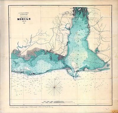
United States Coast Survey.
Southern Mississippi and Alabama : showing the approaches to Mobile / Coast
Survey Office, A.D. Bache, supt.
[Washington, D.C.] : The Office, 1863.
|

cw0488000
|
Heald, D. A. (Daniel Addison), 1818-1900.
The approaches from Washington, to Richmond From surveys supplied by officers
of the army. Entered according to Act of Congress in the year 1862 by D.
A. Heald.
[New York, 1864]
|

cw0564800
|
King, Porter.
Map of the positions of the Fourth Alabama Regt. during the battle of Stone
Bridge / [drawn by Capt. Porter King, C.S.A., 20-21 July 1861]
[1861]
|

cw0703000
|
United States. Navy.
[Map of the defeat of the Confederate ship Alabama by the U.S. steamer Kearsarge
on June 19, 1864, off Cherbourg, France].
Philada., Lith. of Bowen & Co., [1864]
|

np000154
|
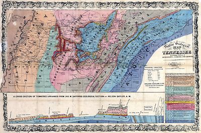
Saylor, Nelson.
An outline geological map of Tennessee, including portions of Mississippi,
Alabama, and Georgia.
Cincinnati, O., 1866.
|

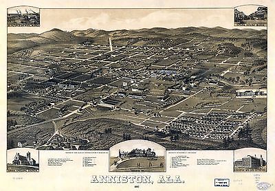
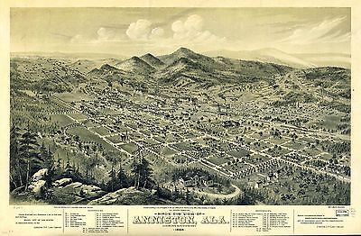
pm000010
|
Henry Wellge & Co.
Anniston, Ala. 1887. Beck & Pauli Lith. Co.
Milwaukee [1887]
|

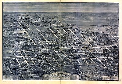
pm000020
|
Glover, E. S.
Bird’s eye view of Anniston, Ala. 1888. Drawn and published by E. S.
Glover. Shober & Carqueville Litho. Co.
Chicago, c1888.
|

pm000030
|
Dry, Camille N.
Bird’s eye view looking northwest, city of Anniston, Calhoun County,
Alabama. Drawn by C. N. Dry.
N[ew] Y[ork] Chas. Hart, lith., c1903.
|

pm000040
|
Wellge, H. (Henry)
Birmingham, Alabama. H. Wellge, del. Beck & Pauli, litho.
Milwaukee, Norris, Wellge, & Co., c1885.
|

pm000050
|
Dry, Camille N.
Business section of the city of Birmingham, Alabama. Drawn in 1903 by C.
N. Dry.
[n.p.] c1904.
|

pm000060
|
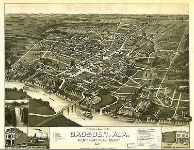
Wellge, H. (Henry)
Perspective map of the city of Gadsden, Ala. county seat of Etowah County
1887. [Drawn by] H. Wellge. Beck & Pauli Lith. Co.
Milwaukee, Henry Wellge & Co. [1887]
|

pm000070
|
[Ruger, A.]
Bird’s eye view of the city of Huntsville, Madison County, Alabama 1871.
|

pm000080
|
Wellge, H. (Henry)
Perspective map of Montgomery, State capital of Alabama. H. Wellge, sk. Beck
& Pauli Lith. Co.
Milwaukee, Henry Wellge & Co., 1887.
|

pm000090
|
Wellge, H. (Henry)
Perspective map of Selma, Ala. county seat of Dallas County 1887.
|

pm000100
|
Wellge, H. (Henry)
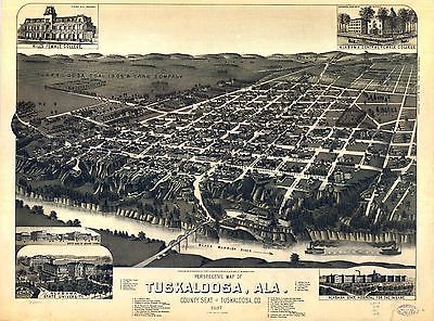
Perspective map of Tuskaloosa, Ala. county seat of Tuskaloosa, Co. 1887.
|

rr000450
|
Colton, J. H. (Joseph Hutchins), 1800-1893.
Colton’s rail-road and military map of the United States, Mexico, the
West Indies, &c.
New York, 1862
|

rr001400
|
United States Coast Survey.
Southern Mississippi and Alabama showing the approaches to Mobile.
[Washington, 1863]
|

rr001410
|
Mendenhall, Edward.
Railway and county map of the Southern States; embracing the States of N.
Carolina, S. Carolina, Georgia, Alabama, Florida, Mississippi, Louisiana,
Arkansas, and Tennessee exhibiting all the towns, villages, stations, &
landings; the rivers, railways, common roads, canals throughout these states.
Engraved by Jos. Beuther.
Cincinnati, E. Mendenhall, 1864.
|

rr001780
|
United States. General Land Office.
State of Alabama. October. 2nd. 1866.
Phila[delphia], [1866]
|

rr001790
|
Alabama. Railroad Commissioners.
Map of Alabama.
Chicago, 1888.
|

rr002000
|
Burr, David H., 1803-1875.
Map of Georgia & Alabama exhibiting the post offices, post roads, canals,
rail roads & c.; by David H. Burr (Late topographer to the Post Office),
Geographer to the House of Representatives of the U.S.
[London, 1839]
|

rr003160
|
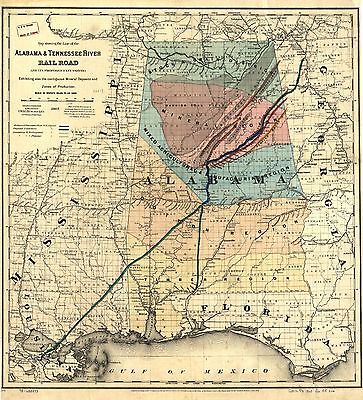
G.W. & C.B. Colton & Co.
Map showing the line of the Alabama & Tennessee River Rail Road and its
proposed extensions; exhibiting also the contiguous mineral deposits and
zone of production.
New York, 1867, c1865.
|

rr003880
|
Palmer, W. R. (William R.), d. 1862.
A map of part of Alabama & Florida, showing the route of the proposed
Columbus & Pensacola Rail Road, accompanying the report of Major J. D.
Graham, U.S. Topographical Engr. Feb. 6th, 1836; drawn chiefly from the original
surveys in the Gen. Land Office at Washington by Wm. R. Palmer, U.S. Asst.
Civil Engr.
[n.p., 1836]
|

rr004760
|
G.W. & C.B. Colton & Co.
Map showing the line of the New Orleans, Mobile & Chattanooga Railroad,
and also the chief agricultural and mineral districts of the state of Alabama.
New York, 1867, c1865.
|

rr004940
|
Hoyer & Ludwig.
Map showing the N.E. & S.W. Alabama R.R. with its connections also the
principal routes between New York and New Orleans.
Richmond, Va., [185-]
|

rr004950
|
Sanford, E. D.
H. V. Poor’s rail road map showing particularly the location and connections
of the North East & South West Alabama Rail Road, by E. D. Sanford, Civil
Engineer.
[n.p., 1854]
|

rr005440
|
G.W. & C.B. Colton & Co.
Map of the Richmond & Danville Railroad system in Virginia, North Carolina,
South Carolina, Georgia, Tennessee, Alabama, Mississippi, Arkansas, &
Texas.
New York, 1881.
|

rr005540
|
G.W. & C.B. Colton & Co.
Map showing the line of the Savannah & Memphis Railroad and its connections.
New York, 1872.
|

rr005740
|
G.W. & C.B. Colton & Co.
Map showing the proposed Tennessee, Alabama, and Georgia Railroad connecting
and extending the Chattanooga Southern Railway, Marietta and North Georgia
Railway, Knoxville, Cumberland Gap and Louisville Railroad, and Morristown
and Cumberland Gap Railroad.
[New York, 1892]
|

rr005750
|
G.W. & C.B. Colton & Co.
Map showing the proposed Tennessee, Alabama, and Georgia Railroad.
New York, c1893.
|

1889 Territory of Alabama
|

1812 Mississippi Territory
|

Asher & Adams Georgia, Alabama. 1874
|

Bartholomew, John, Alabama. 1856
|

Carey, Alabama. 1825
|

Colton, G.W. Alabama. 1865
|

Colton, G.W. Alabama. 1869
|

Finley, Anthony Map of Louisiana Mississippi and Alabama 1826
|

Finley, Anthony, Louisiana, Mississippi and Alabama 1827
|

Grigg, John , Louisiana, Mississippi and Alabama 1830
|

Johnson, A.J. Georgia and Alabama 1864
|

Johnson, A.J. Georgia and Alabama. 1870
|

Johnson, A.J. Georgia And Alabama. 1865
|

Mitchell, Samuel Augustus New Map of Alabama with its roads and distances
1849
|

County map of the states of Georgia and Alabama. (with) Savannah,
Georgia. (with) City of Atlanta, the capitol of Georgia. Copyright by S.
Augustus Mitchell 1884.
|

Indian Territory, Arkansas, Mississippi, Alabama, Tennessee, Missouri,
Kentucky, Louisiana
|

Colton's Alabama, 1886
|

Georgia, Alabama, and Florida. (inset) Florida Keys. 1858
|

1948 Alabama
|

Rand, McNally & Co.'s Alabama. 1889
|

Alabama. Published by George F. Cram, Chicago, Ill. 1909
|

Sketch map showing the position of the center of the Negro population
and the median point in 1880, 1890 and 1900 (United States Census Office,
1903).
|

Covers Mississippi and parts of Louisiana, Arkansas, Tennessee, Alabama
and Florida. 1827
|
Alabama, Arkansas, Louisiana, and Mississippi. (by H.H. Lloyd. Published
by Stedman, Brown & Lyon, Baltimore. 1873)
|

Map of South Carolina, Georgia, Florida, Alabama, Mississippi, and
Louisiana. 1873
|

Alabama. Young & Delleker Sc. Published by A. Finley Philada.
1824
|

Mississippi, and Alabama Territory. 1818
|

Georgia And Alabama By H.S. Tanner. Improved To 1825
|

Panorama of the Seat of War. Birds Eye View Of Louisiana, Mississippi,
Alabama And Part Of Florida. 1861
|

Map of the Country belonging to the Cherokee and Creek Indians J.
Melish del. (1824)
|

Alabama. 1901
|

Alabama. 1903
|

Map of the State of Alabama 1848
|

Alabama; Georgia 1860
|

Alabama, Georgia, Florida 1863
|

Louisiana Mississippi & Alabama 1835
|

Alabama; Georgia 1872
|

Kentucky, Tennessee, Mississippi, Alabama. 1852
|

Mississippi, Alabama, Florida, Georgia. 1852
|

A New Map of Alabama 1853
|

Alabama; Florida; Georgia; South Carolina 1857
|

Map of Louisiana, Mississippi And Alabama S. Augustus Mitchell1831.
|

Alabama 1878
|

Railroad And County Map Of Alabama. Engraved for Grant's Business
Atlas. 1887
|

Mississippi and Alabama. 1865
|

A new map of Alabama 1855
|

A New Map of Alabama with its Roads & Distances from place to
place along Stage and Steam Boat Routes. 1856
|

Johnson's Georgia and Alabama. 1874
|

Mississippi Territory 1814
|

Alabama. Canals, roads, railroads, and rivers shown. 1848
|

Colton's Alabama. 1874
|
Map of the State of Alabama. By David H. Burr. 1835
|

Railroad and County Map of Alabama. Geo. F. Cram. 1889
|

Gray's Atlas Map of Alabama. 1874
|

Colton's Alabama. 1866
|

Georgia and Alabama. By H.S. Tanner. 1825.
|

Alabama. Drawn and Published by F. Lucas Jr. 1822
|

Alabama, Mississippi and Louisiana. 1823
|

Rand McNally & Co.'s Alabama. 1883
|

Asher & Adams' Georgia & Alabama.1874
|

Rand McNally Standard Map of Alabama. (with) Birmingham and Vicinity.
1924
|

Rand McNally Black and White Mileage Map, Alabama 1924
|

County Map of the States of Georgia and Alabama. (insets) Savannah,
Georgia. City of Atlanta, the Capitol of Georgia. 1874 by S. Augustus
Mitchell
|

Schonberg's Map of Alabama. 1866
|

A New Map Of Alabama With Its Roads & Distances from place to
place, along the Stage & Steam Boat Routes by H.S. Tanner. 1841
|

Shows cities, British consular offices, railroads, canals, roads,
lights and lighthouses. Georgia and parts of Tennessee, North Carolina, South
Carolina, Florida and Alabama. 1883
|

Georgia and Alabama By H.S. Tanner. Published by H.S. Tanner, 1823
|

Alabama. 1855 by J.H. Colton
|

Alabama. by Jos. Perkins. 1845
|

Rand McNally junior auto road map Alabama. 1927
|

County map of the states of Georgia and Alabama. (with) Savannah,
Georgia. (with) City of Atlanta 1886 by Wm. M. Bradley & Bro.
|

An Accurate Map of the State of Alabama and West Florida: By John
La Tourette, 1838.
|
|
| Thanks for bidding.
Ad and DVD copyright 2012
Euriskodata, Inc.
All Rights Reserved |
The free listing tool. List your items fast and easy and manage your active items.
|