| Railroad map of Indiana. 1896 |
 |
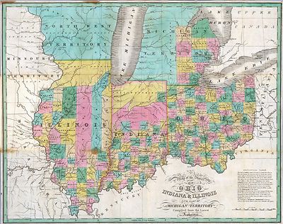
| Cram's township and rail road map of Indiana. 1888 |
 |
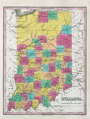
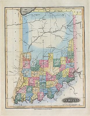
| Johnson's map of Indiana showing the rail roads and townships
compiled from the latest & best authorities. 1858 |
 |
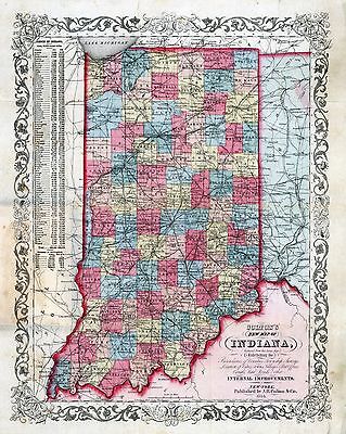
| Colton's map of the state of Indiana, compiled from the United
States surveys & other authentic sources, exhibiting sections, fractional
sections, railroads, canals &c. 1860 |
 |
| Rail road map accompanying the report an[d] exhibit of the Logansport
& Northern Indiana Railroad showing its connections and the through route
from St. Louis to New York of which this road forms a part; Logansport, Indiana
May 1st 1854; L. S. Nash, Chief Engineer. |
 |
| View of Tell City, Perry County, Indiana : Praemie zum Tell City
Anzeiger / A. Hinnen. 187? |
 |
| Map showing the lines of the Columbus, Chicago, and Indiana Central
Railway, and their connections. 1868 |
 |
| Map of the Fremont and Indiana Rail Road and its connections,
December 1858. |
 |
| Map of the Bellefontaine and Indiana Railroad and connecting
lines.1852 |
 |
| Railroad map of Indiana, by Col. Thomas A. Morris, Civil Engineer,
1850 |
 |
| The Indiana, Bloomington and Western Railway System.
1881 |
 |
| Map showing the Indiana & Illinois Central Railway and its
connections. 1872 |
 |
| A section of Colton's large map of Indiana with the Fort Wayne
and Southern Rail Road marked upon it, as located also a map of the United
States showing Road and its connections together with a profile of the Ohio
river and lands adjoining and a section of the double track rail road tunnel
under the Ohio river at Louisville, Kentucky & Jeffersonville, Indiana
for the year 1855 ending Oct. 1, W. J. Holman, President and Chief Engr.
1855 |
 |
| Railroad map of Indiana. 1850 |
 |
| Map showing the Grand Rapids & Indiana Railroad, and its
connections. 1871 |
 |
| Map of the state of Indiana compiled from the United States surveys
by S. D. King, Washington City; exhibiting the sections & fractional
sections; the situation & boundaries of counties; the location of cities
villages & post offices canals, rail roads and other internal improvements,
carefully laid down.1852 |
 |
| Birds eye view of Greencastle, Indiana, 1886 / J. Wallis Smith,
del. |
 |
| Bird's eye view of the city of Peru, Miami Co., Indiana
1868. |
 |
| Griswold's birdseye view of the city of Fort Wayne, Indiana indexed
for ready reference. B. J. Griswold. 1907 |
 |
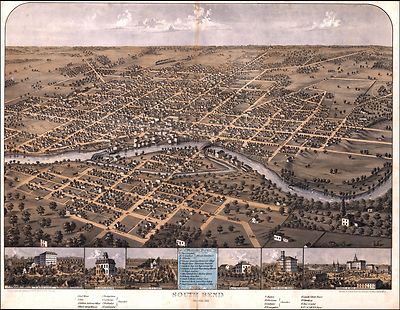
| South Bend, Indiana 1866. Drawn & published by A.
Ruger. |
 |
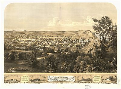
| Bird's eye view of Michigan City, La Porte County, Indiana 1869.
Drawn by A. Ruger. |
 |
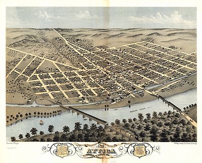
| Bird's eye view of the city of Attica, Fountain County, Indiana
1869. Drawn by A. Ruger. |
 |
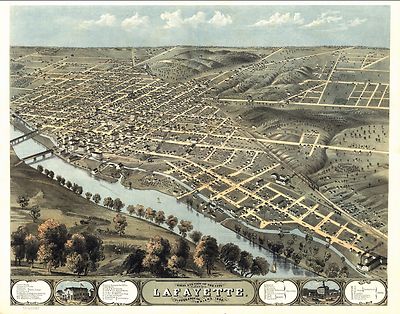
| Bird's eye view of the city of Lafayette, Tippecanoe Co., Indiana
1868. Drawn by A. Ruger. |
 |
| Birds eye view of the city of Kokomo, Howard Co., Indiana 1868.
Drawn by A. Ruger. |
 |
| Bird's eye view of the city of Delphi, Carroll Co., Indiana 1868.
Drawn by A. Ruger. |
 |
| Bird's eye view of the city of Fort Wayne, Indiana 1868. Drawn
by A. Ruger. |
 |
| The city of Richmond, Indiana 1884. [By] Albert Downs. Printed
by J.W.C. Gilman & Co. |
 |
| Galbraith's railway mail service maps, Indiana. c1898 |
 |
| South Bend, Indiana 1874. Chas. Shober & Co. proprietors
of Chicago Lith |
 |
| Map of the Pittsburg [sic], Fort Wayne & Chicago, Cleveland
and Pittsburg [sic], Grand Rapids and Indiana, and Pennsylvania railroads.
c1874 |
 |
| Panoramic view of Terre Haute, Ind. 1880. |
 |
| South Bend, Ind. 1890. |
 |
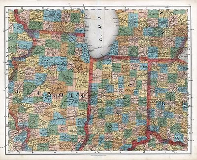
| Chapman's rail road map of Ohio, Indiana, Michigan, Illinois,
Missouri, Minnesota, & Wisconsin. 1859 |
 |
| Perspective map of the city of Evansville, Ind. 1888. H. Wellge,
sk. |
 |
| Map showing the Jacksonville North Western and South Eastern
Railway and its connections. 185? |
 |
| Bird's eye view of Michigan City, LaPorte County, Ind.
1869. |
 |
| Indiana, Illinois, Missouri & Iowa with parts of adjoining
states. 1858 |
 |
| Map showing the Ohio Southern R.R. and its connections through
the Cincinnati, Sandusky & Cleveland and Indiana, Bloomington & Western
Railroads. 1881 |
 |
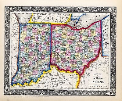
| Colton's county & township rail road map of Ohio, Indiana,
& Michigan, with parts of adjoining states & Canada; printed by Lang
& Laing, 1859. |
 |
| Guide through Ohio, Michigan, Indiana, Illinois, Missouri, Wisconsin
& Iowa; by J. Calvin Smith, engraved by S. Stiles, Sherman & Smith.
c1840 |
 |
| Maps showing the Toledo, Cincinnati, & St. Louis Railroad
and its connections, 1881. |
 |
| Map of the projected railway from Harrisburg to Pittsburg [sic]
with proposed extensions to Cleveland, Cincinnati and St. Louis, in connexion
[sic] with the public works of Pennsylvania, Ohio, Indiana and Illinois /
projected by E.F. Gay, C.E., drawn by J. A. Sheaff, Asst. C.E. 1840 |
 |
| Map showing the line of the Plymouth, Kankakee, & Pacific
Railroad and its connections. This is the Indiana portion of a projected
railroad from Plymouth, Ind., on the Pittsburgh, Fort Wayne, and Chicago
Railroad, to Bureau Junction, on the Chicago, Rock Island, and Pacific Railroad.
1871 |
 |
| Map of the northwestern states. Shewing [sic] what proportion
lies north of the parallel of South Bend of Lake Michigan. It will be seen
at a glance, that the unbroken line of communication with the Atlantic seaboard,
and the only winter route for northern Indiana, northern Illinois, Michigan,
Iowa, Wisconsin, and Minnesota, will be by the Michigan Southern Railway,
and south shore of Lake Erie. 1850 |
 |
| Western border states Waters and son Eng. |
 |
| The Tribune war maps [Compiled by] G. Woolworth Colton. .--A
map of the seat of war in the West [Illinois, Indiana, Kentucky, and Missouri
by J.H. Colton 1861 Page 1 |
 |
| The Tribune war maps [Compiled by] G. Woolworth Colton. .--A
map of the seat of war in the West [Illinois, Indiana, Kentucky, and Missouri
by J.H. Colton 1861 Page 1 |
 |