An illustrated historical atlas of the state of Minnesota. |
 |
| An illustrated historical atlas of the state of Minnesota. |
 |
| An illustrated historical atlas of the state of Minnesota. |
 |
| Outline map of Minneapolis and St. Paul. 1897 |
 |
| Chippewa National Forest, Minnesota / U.S. Department of Agriculture,
Forest Service. 1994 |
 |
| Railroad and post office map of Minnesota and Wisconsin. 1871 |
 |
| Township and railroad map of Minnesota published for the Legislative
Manual, 1874. |
 |
| Minneapolis and Saint Anthony, Minnesota 1867. Drawn by A. Ruger.
1867 |
 |
| Davisons map 25 miles around Minneapolis 1881. |
 |
| Map showing the Burlington Cedar Rapids and Minnesota Railway and
its connections. 1868 |
 |
| Map of Winona County, Minnesota. 1867. |
 |
| Minneapolis, Minnesota. W. V. Herancourt, del. 1885 |
 |
| View of St. Paul, Minnesota. By Geo. Ellsbury and Vernon Green.
1874 |
 |
| Panoramic view of the city of Red Wing, Goddhue [sic] Co., Minnesota,
1880 / Shober & Carqueville, Lith., Co. |
 |
| Carte de la riviere Longue : et de quelques autres, qui se dechargent
dans le grand fleuve de Missisipi [sic] ... ; Carte que les Gnacsitares :
ont dessine sur des paux de cerfs 1703 |
 |
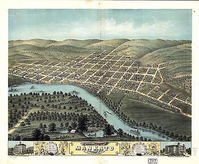
| Bird's eye view of the city of Mankato, Blue Earth County, Minnesota
1870. Merchants Lithographing Co. |
 |
| 1883 bird's eye view of Luverne. County seat of Rock County, Minnesota.
[Drawn by] H. Brosius. Beck & Pauli, lithographers. |
 |
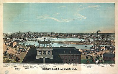
| Panoramic view of the city of Minneapolis, Minnesota, 1879. Drawn
by A. Ruger. Beck & Pauli, lith. |
 |
| Saint Paul, Minnesota 1867. Drawn by A. Ruger. |
 |
| Bird's eye view of Shakopee, Scott County, Minnesota 1869. Drawn
by A. Ruger & Stoner. |
 |
| Lake City, Wabasha Co., Minnesota 1867. Drawn by A. Ruger. |
 |
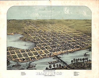
| Bird's eye view of the city of Hastings, Dakota Co., Minnesota 1867.
Drawn by A. Ruger. |
 |
| Bird's eye view of Anoka, Anoka County, Minnesota 1869. Drawn by
A. Ruger. |
 |
| Birds eye view of the city of Winona, Minnesota 1867. Drawn by A.
Ruger. |
 |
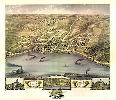
| Bird's eye view of the city of Stillwater, Washington County, Minnesota
1870. Drawn by A. Ruger. |
 |
| Bird's eye view of Northfield, Rice County, Minnesota 1869. Chicago
Lith. Co. |
 |
| St. Paul to Riviere des Lacs : from explorations and surveys / made
under the direction of the Hon. Jefferson Davis, Secretary of War by Isaac
I. Stevens Governor of Washington Territory, 1853-4. |
 |
| Bird's eye view of the city of Redwing, Coodhue [sic] Co., Minnesota
1868. Drawn by A. Ruger. |
 |
| Galbraith's railway mail service maps, Minnesota. c1898 |
 |
| Bird's eye view of the city of Saint Cloud, Stearns County, Minnesota
1869. Drawn by A. Ruger. |
 |
| Bird's eye view of Owatonna, Steele County, Minnesota 1870. Merchants
Lithographing Co. |
 |
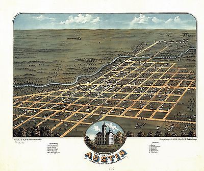
| Bird's eye view of Austin, Mower County, Minnesota 1870. Chicago
Lithogrs. Co. |
 |
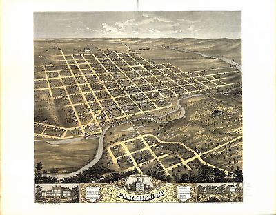
| Bird's eye view of the city of Faribault, Rice County, Minnesota
1869. Drawn by Prof. A. Ruger. |
 |
| Bird's eye view of the city of Saint Peter, Nicollet County, Minnesota
1870. Merchants Lith. Co. |
 |
| Bird's eye view of the city of Rochester, Olmsted County, Minnesota
1869. Merchants Lithographing Co. |
 |
| Bird's eye view of New Ulm, Brown County, Minnesota 1870. Drawn
by A. Ruger. Chicago Lithog. Co. |
 |
| Minneapolis, Minn. Hoffman ; Chas. Shober & Co. Props. Chicago
Litho. Co. c1874 |
 |
| St. Paul, Minnesota 1883 : state capital and county seat of Ramsey
Co. / drawn by H. Wellge. |
 |
| Superior National Forest, Minnesota : 1994 / compiled and drafted
at the Regional Office, Milwaukee, Wis., 1962 |
 |
| Panorama of Minneapolis, Minn. Engraved, printed and published by
A. Hageboeck. 1873 |
 |
| St. Paul, Minn. c1906 |
 |
| Panorama of St. Paul, Minn. Engraved, printed and published by A.
Hageboeck. 1873 |
 |
| Bird's-eye view of St. Paul, looking west from Dayton's Bluff.
c1893 |
 |
| Brainerd, "City of Mines." [Signed:] McCoy. Duluth Photo-Engraving
Co. c1914 |
 |
| Birds eye view of the city of Minneapolis, Minn. 1891 |
 |
| St. Paul, Minn. : ice palace and winter carnival souvenir /
Marr-Richards Engravers, Milwaukee. c1887 |
 |
| Winona, Minn. 1889. C. J. Pauli, del. |
 |
| Bird's eye view of Minneapolis, Minn. F. Pezolt, artist. E. G. Christoph
Lith. Co. c1891 |
 |
| View of Duluth, Minn. 1883. Drawn by H. Wellge. Beck & Pauli,
lithographers. |
 |
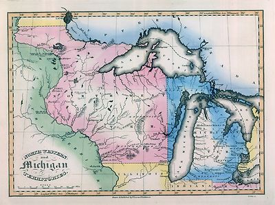
| Chapman's rail road map of Ohio, Indiana, Michigan, Illinois, Missouri,
Minnesota, & Wisconsin. 1859 |
 |
| Perspective map of Duluth, Minn. 1887. Drawn by H. Wellge. Beck
& Pauli Lith. |
 |
| Winona, Minn. By Geo. H. Ellsbury & Vernon Green. 1874 |
 |
| The twin ports, Superior, Wisconsin, Duluth, Minnesota. H. Wellge,
del. Freeman Eng. Co. c1915 |
 |
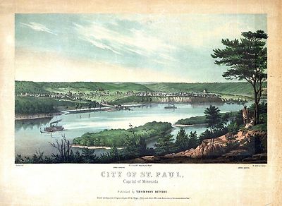
| City of St. Paul, capital of Minesota / published by Thompson Ritchie
; Strobel, delt. ; on stone by J. Queen. 1853 |
 |
| Map showing the location of the Chicago & Northwestern Railway
with its branches & connections through Illinois, Iowa, Nebraska, Wisconsin,
Minnesota, Michigan.1862 |
 |
| Map showing the location of the Galena & Chicago Union Railroad
with its branches & connections in Illinois, Wisconsin, Iowa and
Minnesota. 1862 |
 |
| Map of the northwestern states. Shewing [sic] what proportion lies
north of the parallel of South Bend of Lake Michigan. It will be seen at
a glance, that the unbroken line of communication with the Atlantic seaboard,
and the only winter route for northern Indiana, northern Illinois, Michigan,
Iowa, Wisconsin, and Minnesota, will be by the Michigan Southern Railway,
and south shore of Lake Erie. 1850 |
 |
| Map military reconnaissance Dep't Va. : [Hampton Roads and Norfolk
regions, Va.] / drawn and compiled under the direction of Col. T.J. Cram,
Chief Top'l Enge'r Dep. Va. ; by Sergt. Ch. Worret. Locates the "Minnesota
8 & 9 March 1862 on ground" and the "Monitor & Merrimac engagement
on the 9th of March 1862". |
 |