Click Here. Double your traffic. Get Vendio Gallery - Now FREE!
Coins of India Reference Library
This CD is part of our Historic Atlas
Collection.
We have dozens of Atlas maps on CD ranging from the 1500s to the
1900s covering many areas and topics.
Please Check our Ebay Store for what's available. |
VERY LARGE HIGH RESOLUTION
MAP COLLECTION
ON CD-ROM!!
(please see full table of contents and sample
illustrations below) |
|
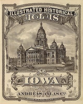
Title of
this
Atlas:
A.T. Andreas'
Illustrated Historical Atlas of the State of
Iowa
(7th Congressional District ed.).
Published by the Andreas Atlas Co., Lakeside Building, Chicago,
Ills.
Engraved & printed by Chas. Shober & Co., Props. of Chicago
Lithographing Co.
1875 |
Features of this CD-ROM
This auction is for a CD -ROM of the maps listed
in electronic form,
NOT
the maps
themselves.
These maps are VERY high resolution and
can be printed at FULL SCALE or LARGER for framing and display. The results
are very high quality and convincing The files are in PDF format for easy
of viewing and printing.
Maps can be viewed and many scales and zoom
features are available as with any PDF file. |
|

0018001
|
Davenport, Iowa, as seen from south west. |

0018002
|
Title Page: A.T. Andreas' illustrated hist. atlas of the State of Iowa |

0018003
|
(Portraits of) Cyrus C. Carpenter, Governor, W.M. Stone, Chester C. Cole,
William E. Miller, John F. Dillon, Josiah T. Young, Caleb Baldwin, Oliver
Mills, Alonzo Abernethy, David Secor, H.O. Pratt, B.F. Gue, G.F. Magoun.
Chas. Shober & Co. props. Chicago Litho. Co. |

0018004
|
Council Bluffs, Iowa from north; residences in E. Des Moines & Council
Bluffs. |

0018005
|
Geological map of the State of Iowa, Climatological map of the State
of Iowa. |

0018006
|
Western Hemisphere. |

0018007
|
Eastern Hemisphere. |

0018008
|
Maps of the State of Iowa showing representative districts, senatorial
districts. |

0018009
|
Maps of the State of Iowa showing congressional districts, judicial
districts. |

0018010
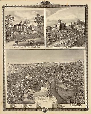
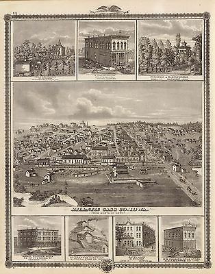
|
Atlantic, Iowa; farms & bldgs., Cass Co., Davenport, Altoona, Chariton
& Albia. |

0018011
|
Herd, residences, buildings & churches, W. Liberty, Mt. Vernon, Decorah,
Spillville, Bloomfield, Cresco and Marshalltown, Iowa. |

0018012
|
New railroad map of the United States, ... Canada, Mexico and the West
Indies. |

0018013
|
Residence, West Liberty; College, Decorah; and Building, W. Des Moines,
Iowa. |

0018014
|
Decorah, Winnesheik Co., Iowa, from bluff over the ice cave. |

0018015
|
Sectional map of Iowa. |

0018016
|
Bird's eye view of Muscatine City; residences in Des Moines & Dubuque,
Iowa. |

0018017
|
Population - United States census, 1870. Density, Foreign, Colored, British
American, Swedish and Norwegian. |

0018018
|
Agricultural productions colored by grades to show quantity raised in
localities. Wheat, hay, corn, cotton, tobacco. |

0018019
|
Vital statistics, United Census, 1870: Deaths from ... diseases. |

0018020
|
Map of Allamakee County |

0018021
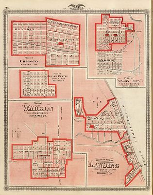
|
Plans of Cresco, Butler Centre, Waukon, Mason City, and Lansing. |

0018022
|
Residences in Linn and Desoto, Dallas Co., Iowa. |

0018023
|
Abner Hill and John Barto residences, Dallas Co., Iowa. |

0018024
|
Map of Winneshiek County, State of Iowa. |

0018025
|
Plans of Decorah, Charles City, Northwood, Elkader and Strawberry Point. |

0018026
|
Charles City, and buildings in Davenport and Cresco, Iowa. |

0018027
|
Osage; Bldgs., farms, residences, Decorah, Ft. Atkinson & Winneshiek
Co., Iowa. |

0018028
|
Residences of Cummins & Justice, Delaware & Douglass Tp., Polk
County, Iowa. |

0018029
|
Residences of M.M. Conger and G.W. Harrison, Adams Tp., Dallas Co., Iowa. |

0018030
|
Map of Howard County |

0018031
|
Map of Mitchell County |

0018032
|
Residences of Swallow, Huston and Cassatt in Boone Tp., Dallas Co., Iowa. |

0018033
|
Residence of G.P. & J. Leyner, Boone Tp., and Adel, Dallas County,
Iowa. |

0018034
|
Map of Worth County, State of Iowa. |

0018035
|
Counties of Emmet, Palo Alto, Kossuth, Winnebago and Hancock, State of
Iowa. |

0018036
|
Plans of Osage, West Union, Webster City and Clermont. |

0018037
|
Map of Wright County, State of Iowa. |

0018038
|
Counties of Lyon, Osceola, Dickinson, Sioux, O'Brien and Clay, State
of Iowa. |

0018039
|
Map of Humboldt County, State of Iowa. |

0018040
|
Residences in Redfield, Waukee, Madison County and Winterset, Iowa. |

0018041
|
Residences of J. Butshall and D.M. Flinn, Dallas Co., Iowa. |

0018042
|
University, Fayette; residences, Davenport, Charles City, Mechanicsville,
& Waukon; Elevator, Marshalltown. |

0018043
|
Farm, businesses in Charles City, Davenport, Ottumwa, Muscatine, Avoca,
Marshalltown, Algona, Allerton, Red Oak and Atlantic. |

0018044
|
Map of Cerro Gordo County, State of Iowa. |

0018045
|
Plans of Algona, Boonsboro and Boone, Iowa. |

0018046
|
Residences and office, Douglas Tp., and Polk City, Polk Co., Iowa. |

0018047
|
Residences of J. Justice, Delaware, and W.G. Madden, Douglas, Iowa. |

0018048
|
Map of Floyd County, State of Iowa. |

0018049
|
Plans of Cedar Falls, Waterloo, Hopkinton and La Porte City, Iowa. |

0018050
|
Map of Chickasaw County, State of Iowa. |

0018051
|
Plans of Cedar Falls, Waterloo, Hopkinton and La Porte City, Iowa. |

0018052
|
Nashua; farm and residence, West Liberty; residences, Davenport, Iowa. |

0018053
|
Farms, businesses, residences, Cedar County, Manchester, Bloomfield,
Oskaloosa, Pella, Freeport, Cresco and Decorah. |

0018054
|
Morning scene, J.D. Rivers stock farm, Des Moines Township, Dallas Co.,
Iowa.Farm, residences & pipe works, Delaware, Dallas Co. & West Des
Moines, Iowa. |

0018055
|
Farm, residences & pipe works, Delaware, Dallas Co. & West Des
Moines, Iowa. |

0018056
|
Map of Franklin County, State of Iowa. |

0018057
|
Map of Bremer County, Plan of Waverly, State of Iowa. |

0018058
|
Map of Butler County, State of Iowa. |

0018059
|
Map of Black Hawk County, State of Iowa. |

0018060
|
Residences, farm, businesses in W. Liberty, Ackley, Cedar Falls, Cedar
Rapids, Calmar, Cresco, Ossian and Calmar, Iowa. |

0018061
|
(Portraits of) J.C. Knapp, J.G. Vale, Daniel Lane, W.P. Staub, Robert
Sloan, Edward Johnstone, Robt. L. Clarke, H. Clay Stuart, Seth H. Craig,
J. Van Valkenburg, Chas. Negus, A.L. Courtright, James Widner, Chas. Fitch,
A.R. Anderson, E.C. Bosbyshell, William Gilley, J.M. Beck, S.W. Miller, E.
Houck, J.M. Hammond, W.G. Read, A.C. Roberts, John S. Monk, John E. Selleck,
F.B. Cornell, O.F. Hixon, Mrs. Lizzie B. Read, John Maben, Samuel Russell,
O.H.P. Shoemaker. Chas. Shober & Co. props. Chicago Litho. Co. |

0018062
|
Residences and store in Polk County, Polk City and Altoona, Iowa. |

0018063
|
Farm residence of I. Lee & residence of T. Mitchell, Beaver Tp.,
Polk Co., Iowa. |

0018064
|
Map of Benton County, State of Iowa. |

0018065
|
Plans of Vinton, Blairstown, Nevada and Belle Plaine. |

0018066
|
Map of Fayette County, State of Iowa. |

0018067
|
Plans of Sioux Rapids, Onawa, Storm Lake, Newell and Earlville. |

0018068
|
City of Storm Lake; brewery, Muscatine; bldg., Lemar; mill, Cedar Rapids. |

0018069
|
Farm, vineyard and residences in Cedar County and Davenport, Iowa. |

0018070
|
Map of Clayton County and buildings in McGregor, State of Iowa. |

0018071
|
Plan of the City of McGregor and Plan of Guttenberg , Clayton Co. |

0018072
|
Map of Dubuque County and view of Lorimier House, Dubuque, Iowa. |

0018073
|
Plan of Dubuque, Dubuque County, State of Iowa. |

0018074
|
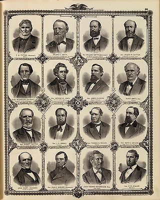
(Portraits of) E.G. Potter, Delano T. Smith, William Smythe, Aylett R.
Cotton, Alex. McGregor, George W. Jones, James Cushing, Platt Smith, Robert
Smythe, J.K. Graves, Thomas S. Wilson, David S. Wilson, John Haney, John
C. Bucher, John Thomas Waterhouse, S.B. Zeigler. Chas. Shober & Co. props.
Chicago Litho. Co. |

0018075
|
Residences & businesses in Muscatine, Davis, Hardin, Polk, Mahaska,
Mitchell, Cerro Gordo & Linn counties and Dubuque and Davenport. |

0018076
|
Map of Delaware County, State of Iowa. |

0018077
|
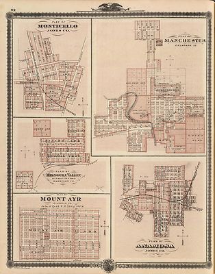
Plans of Monticello, Manchester, Missouri Valley, Mount Ayr and Anamosa. |

0018078
|
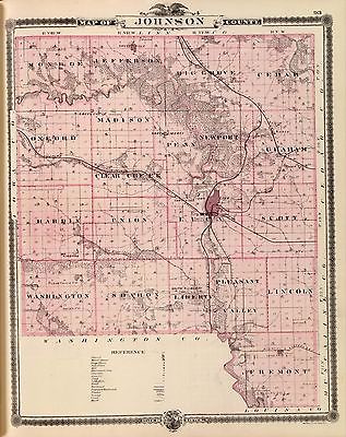
Map of Johnson County, State of Iowa. |

0018079
|
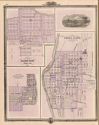
Plan of Iowa City, Plan of Marengo, Plan of Le Claire. |

0018080
|
Map of Buchanan County, State of Iowa. |

0018081
|
Plans of Independence, Jesup, Delphi, Winthrop, Polk City and Quasqueton. |

0018082
|
Map of Hamilton County, State of Iowa. |

0018083
|
Map of Boone County, State of Iowa. |

0018084
|
Residences of D.B. Murrow and Geo. Crawford, Polk Co., Iowa. |

0018085
|
Residences and farms of J. Canfield and J. Wood, Polk and Wayne counties,
Iowa. |

0018086
|
Map of Grundy County, State of Iowa, and Hampton and Grundy Center. |

0018087
|
Map of Hardin County, State of Iowa. |

0018088
|
Farm, residence and Western College in Marshalltown, Atlantic, and Linn
Co. |

0018089
|
Stock farm, Marshalltown; Rockford; Humboldt College, Humboldt, Iowa. |

0018090
|
Map of Guthrie County, State of Iowa. |

0018091
|
Map of Carroll County, State of Iowa. |

0018092
|
Map of Webster County, State of Iowa. |

0018093
|
Plans of Fort Dodge, Humboldt, Ackley and Eldora, Iowa. |

0018094
|
Map of Plymouth County. |

0018095
|
Counties of Pocahontas, Cherokee, Ida, Buena Vista, Calhoun & Sac. |

0018096
|
Map of Woodbury County, State of Iowa. |

0018097
|
Plans of Sioux City, Le Mars, Correctionville and Cherokee. |

0018098
|
Map of Monona County, State of Iowa. |

0018099
|
Mills & Company, Des Moines, Iowa. |

0018100
|
Map of Monona County, State of Iowa. |

0018101
|
Map of Audubon County, State of Iowa. |

0018102
|
Map of Crawford County, State of Iowa. |

0018103
|
Residence of C. Seiberling, farm residence of P.A. Rooker, Polk Co.,
Iowa. |

0018104
|
Residences of J.W. Richardson & J.D. McGlothlen, Wayne & Polk
counties, Iowa. |

0018105
|
Map of Greene County, State of Iowa. |

0018106
|
Harlan, Winterset, Exira, Milton, Oakfield, Bonaparte, Independent &
Logan. |

0018107
|
(Portraits of) Citizens of Dallas County: J. Perkins, T.J. Caldwell,
J.S. DeMotte, Sam'l. Pangburn, G.G. Pierce, S.G. Mark, S.A. Callvert, J.W.
Russell, Wm. Hemphill, J.L. Grace, Sol. Rimer, O.P. Williams. Citizens of
Guthrie and Adair counties: Chas. Stuart, W.B. Conger, M. Ryan, Chas W. Hill,
A.P. Littleton, J.R. Bates, Geo. Gray, Thomas Harris, James E. Roper, S.B.
Moody, Paul Denning, S.D. Nichols, State of Iowa. Chas. Shober & Co.
props. Chicago Litho. Co. |

0018108
|
Iowa State University, colleges, reform school, hospitals for the insane |

0018109
|
Iowa State institutions for blind, orphans, deaf & dumb and prisons. |

0018110
|
(Portraits of) Citizens of Cass County, State of Iowa: Isaac Dickerson,
Wm. Waddell, J.W. Brown, G.W. Norton, Oll Coomes, H. Temple, Lafayette Young,
Theo. Cushing, J.W. Emmert, Newton Richards, Wm. Gardener, M.J. Davis, Thos.
Meredith, S.H. Taft, W.A. Stow, T. Brown, C.L. Hart, W.A. Fulmer, Joseph
Hayne, James A. Sawyers, Chas. H. Bennett, W.C. Smith, Geo. Kendrick, T.J.
Armantrout. Chas. Shober & Co. props. Chicago Litho. Co. |

0018111
|
Map of Story County, State of Iowa. |

0018112
|
Map of Harrison County, State of Iowa. |

0018113
|
Residences and farms in Benton Tp., Wayne Co. and Grant Tp., Polk Co.,
Iowa. |

0018114
|
Residences and school in Garden Grove, and Decatur Tp., Decatur Co.,
Iowa. |

0018115
|
Map of Marshall County, State of Iowa. |

0018116
|
Marshalltown, Albion, Gilman, Le Grand, Liscomb, Marshall Co |

0018117
|
Lansing, Waukon, and residences in Nevada, Atlantic and Des Moines, Iowa. |

0018118
|
(Portraits of) Citizens of Cedar Rapids, Linn County, State of Iowa:
George Greene, S.C. Bever, W.W. Walker, T.M. Sinclair, H.G. Higley, S.L.
Dows, Gabriel Carpenter, E.S. Hill, C.C. Cook, D.W.C. Rowley, E.L. Mansfield,
J.R. Kinney, Thos. Gainer, J.F. Ely, A.B. Hull, W.D. Watrous, Wm. Stewart,
J.G. Graves, J.S. Cook, J.M. May. Chas. Shober & Co. props. Chicago Litho.
Co. |

0018119
|
Map of Tama County, State of Iowa. |

0018120
|
Map of Iowa County, State of Iowa. |

0018121
|
Map of Keokuk County, State of Iowa. |

0018122
|
Plans of Sigourney, Brighton, Agency City and Washington, State of Iowa. |

0018123
|
(Portraits of) Addison Daniels, R.D. Stephens, I.M. Preston, J.B. Young,
N.W. Owen, Thomas Corbett, William Fuller, J.D. Bourne, I.J. Mitchell, E.D.
Waln, Thomas Hatfield, Geo. Whitfield Ames, H.A. Gerhart, Geo. S. Shaw, J.H.
Warren, J.M. Gates, James Grant, Alfred Sanders, Samuel Lyter, N.B. Howard,
State of Iowa. Chas. Shober & Co., props., Chicago Litho Co. |

0018124
|
Cherokee, Iowa, 1875; businesses in Centerville, Ottumwa, Clarence, etc |

0018125
|
Map of Washington County, State of Iowa. |

0018126
|
Plan of Marion and Plan of Cedar Rapids. |

0018127
|
Map of Linn County, State of Iowa. |

0018128
|
Plans of Maquoketa, Bellevue, Princeton, Preston, Guthrie Cntr., Panora,
Miles, Sabula & Buffalo. |

0018129
|
Chariton, Iowa; businesses in Davenport, Oskaloosa, Manchester, etc. |

0018130
|
Union Valley Stock Farm, Cedar Co.; businesses, residences in Spillville,
etc. |

0018131
|
Map of Jones County, State of Iowa. |

0018132
|
Map of Jackson County. |

0018133
|
"Oakland" residence, Garden Grove; Residence in Center Tp., Iowa. |

0018134
|
Residences of W.H. Hartsook and T.W. Parker, Polk County, Iowa. |

0018135
|
Map of Clinton County, State of Iowa. |

0018136
|
Plans of Lyons and Clinton, Clinton County, State of Iowa. |

0018137
|
Map of Scott County, State of Iowa. |

0018138
|
Plan of Davenport, Scott County, State of Iowa. |

0018139
|
(Portraits of) Citizens of Scott County, State of Iowa: John L. Davies,
Geo. Davenport, Daniel Newcomb, James M. Bowling, Geo. L. Davenport, C.S.
Watkins, John Forrest, Harvey Leonard, William Renwick, B.B. Woodward, H.H.
Andreson, M.J. Rohlfs, M. Donahue, John M. Lyter, A.C. Fulton, Ed. Russell,
J.W. Stewart, Jonathan Parker, A.S. Maxwell, Jonathan W. Parker, Israel Hall,
J.M. Eldridge, James Renwick, Samuel R. Millar, E.B. Hazen, G.C.R. Mitchell,
Wm. L. Cook, Charles H. Kent. Chas. Shober & Co., props., Chicago Litho
Co. |

0018140
|
Academy of the Immaculate Conception, Davenport Business College, residences. |

0018141
|
Map of Cedar County, State of Iowa. |

0018142
|
Plans of DeWitt, Tipton, West Branch and Clarence, State of Iowa. |

0018143
|
Map of Marion County, State of Iowa. |

0018144
|
Lineville, Derby, Glidden, Ames, Conway, Pulaski, Lenox, Melrose, Drakeville,
State of Iowa. |

0018145
|
Map of Poweshiek County, State of Iowa. |

0018146
|
Plans of Brooklyn, Grinnell, Montezuma and Malcolm, State of Iowa. |

0018147
|
"Cherry Grove," "Hillside Farm," and Wadsworth home, Warren Co., Iowa. |

0018148
|
Residences of Caldwell, Fox, Hargis and Hurd, Wayne and Polk counties,
Iowa |

0018149
|
Map of Jasper County, State of Iowa. |

0018150
|
Plans of Newton, Prairie City, Kellogg and Monroe, State of Iowa. |

0018151
|
City of DesMoines from South Park Hill, with Hawkeye Insurance Co. |

0018152
|
(Portraits of) Citizens of Polk County, State of Iowa: Thomas Mitchell,
B.F. Allen, Wesley Redhead, Samuel Merrill, J.H. Hatch, G.D. Moore, L.P.
Sherman, S.F. Spofford, R.B. Armstrong, N.R. Kuntz, J.O. Skinner, T.K. Brooks,
W.S. Grimes, R.A. Patchin, I. Windle, D.M. Bringolf, L.W. Cannon, J.F. Kennedy,
Geo. C. Baker, William Lowry. Chas. Shober & Co., props., Chicago Litho
Co. |

0018153
|
Map of Polk County, State of Iowa. |

0018154
|
Plan of Des Moines, Polk County, Iowa. |

0018155
|
Businesses, coal mine, and plow advertisement, Des Moines and Oskaloosa,
Iowa. |

0018156
|
Businesses in East Des Moines and Des Moines, Iowa. |

0018157
|
Map of Dallas County, State of Iowa. |

0018158
|
Dallas Center, Casey, DeSoto, Dexter, Ogden, Perry, Shell Rock and Adel,
Iowa. |

0018159
|
Map of Pottawattamie County. |

0018160
|
Plan of Council Bluffs, Pottawattamie Co., State of Iowa. |

0018161
|
Map of Cass County, State of Iowa. |

0018162
|
Plans of Atlantic, Osceola, Lewis, Hopeville and Murray, State of Iowa. |

0018163
|
Map of Adair County, State of Iowa. |

0018164
|
Map of Madison County, State of Iowa. |

0018165
|
Map of Warren County, State of Iowa. |

0018166
|
Plans of Chariton, Grand Junction, Mitchellville, and Indianola, State
of Iowa. |

0018167
|
Residence of Isreal Cox, Ward Township, Clarke Co., Iowa. |

0018168
|
Residences of McDivitt and Robinson, Walnut Tp., Polk Co., Iowa. |

0018169
|
Map of Mahaska County, State of Iowa. |

0018170
|
Plans of Oskaloosa, Eddyville and Albia City, State of Iowa. |

0018171
|
(Portraits of) L.W. Tubbs, John Chaney, C.H. Lane, N.B. Moore, S.L. Bestow,
Asa C. Call, W.E. McDuffee, W.G. Clark, D. Anderson, E.E. Edwards, N.L. Van
Sandt, S.H. Mallory, J.H. Drake, J.M. Schaffer, W.S. Dungan, Robert Coles,
W.H. Maple, M.M. Moulton, N.B. Gardner, A.B. Smedley, Alfred Hebard, G.L.
Brooks, Joseph Hobson, State of Iowa. Chas. Shober & Co., props., Chicago
Lith Co. |

0018172
|
Clenona Stock Farm; buildings in Davenport, Bluffton, Decorah and Oskaloosa. |

0018173
|
Map of Muscatine County, State of Iowa and view of Allendale Farm. |

0018174
|
Plans of Muscatine, West Liberty, Pella and Wilton, State of Iowa. |

0018175
|
Pleasant Hill Farm; bldgs. in Decorah, Chariton, Bloomfield, Lansing
& Davenport |

0018176
|
Eagle Brewery, Cedar Rapids; Cresco; bldgs. in Lansing, Allamakee Co.,
Waukon. |

0018177
|
Map of Louisa County, State of Iowa. |

0018178
|
Map of Henry County, State of Iowa. |

0018179
|
Plans of Mt. Plessant, Toledo, Wapello and Tama City, State of Iowa. |

0018180
|
Map of Jefferson County, State of Iowa. |

0018181
|
Map of Wapello County, State of Iowa. |

0018182
|
Plans of Ottumwa, Russell, Scranton, Tyrone, Knoxville & Jefferson,
Iowa. |

0018183
|
Leon, bird's eye view; Carlisle Mills; McBride residence, Garden Grove,
Iowa. |

0018184
|
Garden Grove Herd, Pryor, Harkness and Cary residences, Garden Grove,
Iowa. |

0018185
|
Map of Monroe County, State of Iowa. |

0018186
|
Map of Lucas County, State of Iowa. |

0018187
|
Map of Clarke County, State of Iowa. |

0018188
|
Plans of Glenwood, Denison, Hastings, Villisca, Emerson and Malvern,
Iowa. |

0018189
|
Map of Union County, State of Iowa. |

0018190
|
Map of Adams County, State of Iowa. |

0018191
|
Map of Montgomery County, State of Iowa. |

0018192
|
Plans of Red Oak Junction, Prescott, Walnut, Corning, Corydon and Avoca,
Iowa. |

0018193
|
Red Oak; farm & residence, Center Tp., Cedar Co.; residence, Stacyville,
Iowa. |

0018194
|
Maple Grove Herd, Cedar Co.; New Hampton, Chickasaw Co., Iowa. |

0018195
|
Map of Mills County, State of Iowa. |

0018196
|
Plans of Hamburg, Sidney, Farragut, Riverton and Clarinda, Iowa. |

0018197
|
Map of Fremont County, State of Iowa. |

0018198
|
Map of Page County, State of Iowa. |

0018199
|
Avoca; Penn College, Oskaloosa; buildings in Dexter, Mechanicsville,
etc., Iowa. |

0018200
|
Plans of Shenandoah, Bedford, Avery, Afton and Creston, Iowa. |

0018201
|
Map of Taylor County, State of Iowa. |

0018202
|
Map of Ringgold County, State of Iowa. |

0018203
|
Map of Decatur County, State of Iowa. |

0018204
|
Plans of Centerville, Leon, Moulton, Seymour and Quincy, State of Iowa. |

0018205
|
Residences, farms in Polk, Guthrie & Warren counties, and Des Moines,
Iowa. |

0018206
|
Residences & farm of Warrington, Dallas Co., and of Henson, Warren
Co., Iowa. |

0018207
|
Map of Wayne County, State of Iowa. |

0018208
|
Map of Appanoose County, State of Iowa. |

0018209
|
Map of Davis County, State of Iowa. |

0018210
|
Fairfield, Carroll, Birmingham, Dunlap, Walcott, Keosaqua, Des Moines
& Pleasant Hill. |

0018211
|
Plans of Fort Madison, Bloomfield and Mechanicsville, State of Iowa. |

0018212
|
Map of Van Buren County, State of Iowa. |

0018213
|
Map of Des Moines County, State of Iowa. |

0018214
|
Plans of Burlington, Greenfield, Fontanelle and Stuart, State of Iowa. |

0018215
|
Map of Lee County and Montrose, State of Iowa. |

0018216
|
Plans of Keokuk, Forest City, Greene and Garner, State of Iowa. |

0018B
|
Title Page |

0018C
|
Index |

0018D
|
Index |

0018E
|
Index |

0018F
|
Index |
|
Ad and CD-ROM copyright 2011
Euriskodata
All Rights Reserved |
The free listing tool. List your items fast and easy and manage your active items.
|