Maps of
Kentucky

0028046
|
(Arrowsmith, Aaron); Lewis, Samuel
Date: 1812
Short Title:
Kentucky.
|

0041012
|
Asher & Adams
Date: 1874
Short Title:
Kentucky, Tennessee.
|

0089006
|
Bradford, Thomas G.
Date: 1838
Short Title:
Washington. Louisville and Jeffersonville. New Orleans. Cincinnati.
|

0089026
|
Bradford, Thomas G.
Date: 1838
Short Title:
Kentucky.
|

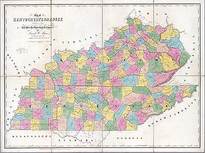
0104011
|
Burr, David H., 1803-1875
Date: 1839
Short Title:
Map of Kentucky & Tennessee.
|

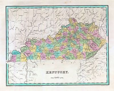
0122022
|
Carey, H. C. ; Lea, I.
Date: 1822
Short Title:
Map Of Kentucky.
|

0149040
|
Colton, G.W.
Date: 1856
Short Title:
The City Of Louisville Kentucky. (with) The City Of New Orleans Louisiana.
|

0149043
|
Colton, G.W.
Date: 1856
Short Title:
Kentucky And Tennessee
|

0278010
|
Finley, Anthony
Date: 1826
Short Title:
Map of Kentucky and Tennessee.
|

0537028
|
Mitchell, Samuel Augustus
Date: 1846
Short Title:
New Map Of Kentucky.
|

0565016
|
Mitchell, Samuel Augustus
Date: 1860
Short Title:
County Map Of Kentucky, And Tennessee.
|

0586023
|
Mitchell, Samuel Augustus
Date: 1880
Short Title:
Kentucky, Tennessee.
|

0594024
|
(Mitchell, Samuel Augustus)
Date: 1890
Short Title:
Kentucky, Tennessee.
|

0632018
|
Morse, Jedidiah
Date: 1794
Short Title:
Kentucky.
|

0845015
|
Reid, John ; Winterbotham, W.
Date: 1796
Short Title:
State of Kentucky.
|

0977024
|
Tanner, Henry S.
Date: 1836
Short Title:
New Map Of Kentucky.
|

1780024
|
United States. War Department
Date: 1895
Short Title:
Army of the Cumberland.
|

2301022
|
Morse, Sidney E. (Sidney Edwards), 1794-1871; Breese, Samuel, 1802-1873
Date: 1845
Short Title:
Kentucky, Tennessee.
|

2341004
|
Melish, John
Date: 1812
Short Title:
Falls of Ohio.
|

2341005
|
Melish, John
Date: 1812
Short Title:
Kentucky.
|

2436051
|
(Arrowsmith, Aaron); Lewis, Samuel
Date: 1804
Short Title:
Kentucky.
|

2483021
|
Mitchell, Samuel Augustus
Date: 1870
Short Title:
Kentucky, Tennessee.
|

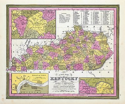
2501017
|
Henshaw, Frances H.
Date: 1828
Short Title:
Kentucky.
|

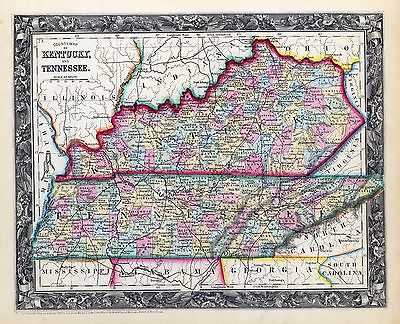
2542017
|
Carey, Mathew ; Barker, Elihu
Date: 1795
Short Title:
Kentucky.
|

2743007
|
Lange, Henry, 1821-1893.
Date: 1854
Short Title:
Kentucky und Tennessee.
|

2755013
|
Tanner, Henry S.
Date: 1825
Short Title:
Kentucky And Tennessee.
|

2757002
|
Imlay, Gilbert
Date: 1797
Short Title:
Rapids of the Ohio.
|

2757003
|
Imlay, Gilbert
Date: 1797
Short Title:
Kentucky.
|

2862040
|
Carey, Mathew
Date: 1796
Short Title:
Kentucky.
|

2905022
|
Johnson, A.J.
Date: 1860
Short Title:
Kentucky And Tennessee.
|

3565101
|
Rand McNally and Company
Date: 1897
Short Title:
Kentucky, Tennessee.
|

3565102
|
Rand McNally and Company
Date: 1897
Short Title:
Louisville.
|

3884010
|
Mitchell, Samuel Augustus
Date: 1831
Short Title:
Map of Kentucky and Tennessee.
|

4453028
|
Goodrich, S.G. ; Bradford, Thomas G.
Date: 1841
Short Title:
Kentucky.
|

4520029
|
Rand McNally and Company
Date: 1879
Short Title:
Kentucky And Tennessee.
|

4577021
|
Carey, Mathew
Date: 1814
Short Title:
Kentucky.
|

4584062
|
Lucas, Fielding Jr.
Date: 1823
Short Title:
Kentucky.
|

4628049
|
Burr, David H., 1803-1875
Date: 1835
Short Title:
Kentucky And Tennessee.
|

4664011
|
Collot, George Henri Victor ; Tardieu, P.F.
Date: 1796
Short Title:
Plan of an Old Fort in the state of Kentucky.
|

4664012
|
Collot, George Henri Victor ; Tardieu, P.F.
Date: 1796
Short Title:
Plan of the Rapids or Falls of the Ohio Latitude of Louisville.
|

4664013
|
Collot, George Henri Victor ; Tardieu, P.F.
Date: 1796
Short Title:
Road from Limestone to Frankfort in the state of Kentucky.
|

4807157
|
Meyer, Joseph, 1796-1856
Date: 1845
Short Title:
Kentucky.
|

4850049
|
Greenleaf, Jeremiah
Date: 1840
Short Title:
Kentucky And Tennessee.
|

4863040
|
Carey, Mathew
Date: 1811
Short Title:
Kentucky.
|

4865015
|
Carey, Mathew
Date: 1796
Short Title:
Kentuckey.
|

4869009
|
(Morse, Sidney E. (Sidney Edwards), 1794-1871)
Date: 1823
Short Title:
Kentucky, Tennessee.
|

4966007
|
(Hinton, John Howard); Hinton, Isaac Taylor, 1799-1847; Simpkin &
Marshall.
Date: 1831
Short Title:
Kentucky, Tennessee.
|

4975114
|
Hayes, Eli L.
Date: 1877
Short Title:
Ashland, Boyd Co., Ky. (with) East Ashland ... Howland, Boyd Co., Ky.
|

4975117
|
Hayes, Eli L.
Date: 1877
Short Title:
Residence of Taylor H. Berry Esq., ... (with) Residence and farm of Lemuel
T. Pyle Esq., Indian Spring, Campbell Co., Ky.
|

4975125
|
Hayes, Eli L.
Date: 1877
Short Title:
Vanceburg, Lewis Co., Ky. (with) Concord, Lewis Co., Ky.
|

4975131
|
Hayes, Eli L.
Date: 1877
Short Title:
City of Maysville ... (with) Chester & Woodville, Dover, Mason Co., Ky.
|

4975132
|
Hayes, Eli L.
Date: 1877
Short Title:
City of Augusta ... (with) Tietzville, Foster, Wellsburgh, Bracken Co., Ky.
|

5045001
|
Hutchins, Thomas
Date: 1778
Short Title:
Rapids, in the River Ohio.
|

5370009
|
Cram Atlas Company
Date: 1875
Short Title:
Kentucky And Tennessee.
|

5384001
|
Swann, Charles E.
Date: 1863
Short Title:
Military Map of the States of Kentucky and Tennessee.
|

5388019
|
Tanner, Henry S.
Date: 1823
Short Title:
Kentucky, Tennessee and part of Illinois.
|

5472002
|
New York Herald ; Hall, E.S.
Date: 1861
Short Title:
Important Operations in Kentucky and Tennessee.
|

ar079200
|
Filson, John, ca. 1747-1788.
Main Title: This map of Kentucke, drawn from actual observations, is inscribed
with the most perfect respect, to the Honorable the Congress of the United
States of America; and to His Excellcy. George Washington, late Commander
in Chief of their Army. By their humble servant, John Filson. Engraved by
Henry D. Pursell & printed by T. Rook.
Published/Created: Philad[elphi]a, 1784.
|

ar301200
|
Filson, John, ca. 1747-1788.
Main Title: This map of Kentucke : drawn from actual observations, is inscribed
with the most perfect respect, to the honorable congress of the United States
of America, and to His Excell’cy George Washington, late commander in
chief of their army / by their humble servant, John Filson ; engrav’d
by Henry D. Pursell & printed by T. Rook for the author.
Published/Created: Philadelphia : H.D. Pursell, [1784]
|

ca000001
|
Map of the surveys made for the U.S.M.R.R., 1863 & 4, from Kentucky
to east. Tenn. / by order of Maj. Gen. A.E. Burnside ; under the direction
of Lt. Col. J.H. Simpson, Corps Engr's, chief eng'r, Dep't of the Ohio, W.A.
Gunn, ch. eng. M.R.R. ; drawn by W.P. Clark, ast. engr., Qr. Mr. Departm't.
Covers parts of Lincoln, Boyle, and Pulaski counties, Kentucky, showing the
proposed route of the military railroad. Roads, towns, houses, names of
residents, fences, relief, vegetation, and drainage are indicated along the
proposed route. |

ca000002
|
Map of the surveys made for the U.S.M.R.R., 1863 & 4, from Kentucky
to east. Tenn. / by order of Maj. Gen. A.E. Burnside ; under the direction
of Lt. Col. J.H. Simpson, Corps Engr's, chief eng'r, Dep't of the Ohio, W.A.
Gunn, ch. eng. M.R.R. ; drawn by W.P. Clark, ast. engr., Qr. Mr. Departm't.
Covers parts of Lincoln, Boyle, and Pulaski counties, Kentucky, showing the
proposed route of the military railroad. Roads, towns, houses, names of
residents, fences, relief, vegetation, and drainage are indicated along the
proposed route. |

ca000003
|
Map of the surveys made for the U.S.M.R.R., 1863 & 4, from Kentucky
to east. Tenn. / by order of Maj. Gen. A.E. Burnside ; under the direction
of Lt. Col. J.H. Simpson, Corps Engr's, chief eng'r, Dep't of the Ohio, W.A.
Gunn, ch. eng. M.R.R. ; drawn by W.P. Clark, ast. engr., Qr. Mr. Departm't.
Covers parts of Lincoln, Boyle, and Pulaski counties, Kentucky, showing the
proposed route of the military railroad. Roads, towns, houses, names of
residents, fences, relief, vegetation, and drainage are indicated along the
proposed route. |

ca000004
|
Map of the surveys made for the U.S.M.R.R., 1863 & 4, from Kentucky
to east. Tenn. / by order of Maj. Gen. A.E. Burnside ; under the direction
of Lt. Col. J.H. Simpson, Corps Engr's, chief eng'r, Dep't of the Ohio, W.A.
Gunn, ch. eng. M.R.R. ; drawn by W.P. Clark, ast. engr., Qr. Mr. Departm't.
Covers parts of Lincoln, Boyle, and Pulaski counties, Kentucky, showing the
proposed route of the military railroad. Roads, towns, houses, names of
residents, fences, relief, vegetation, and drainage are indicated along the
proposed route. |

ca000005
|
Map of the surveys made for the U.S.M.R.R., 1863 & 4, from Kentucky
to east. Tenn. / by order of Maj. Gen. A.E. Burnside ; under the direction
of Lt. Col. J.H. Simpson, Corps Engr's, chief eng'r, Dep't of the Ohio, W.A.
Gunn, ch. eng. M.R.R. ; drawn by W.P. Clark, ast. engr., Qr. Mr. Departm't.
Covers parts of Lincoln, Boyle, and Pulaski counties, Kentucky, showing the
proposed route of the military railroad. Roads, towns, houses, names of
residents, fences, relief, vegetation, and drainage are indicated along the
proposed route. |

ca000006
|
Map of the surveys made for the U.S.M.R.R., 1863 & 4, from Kentucky
to east. Tenn. / by order of Maj. Gen. A.E. Burnside ; under the direction
of Lt. Col. J.H. Simpson, Corps Engr's, chief eng'r, Dep't of the Ohio, W.A.
Gunn, ch. eng. M.R.R. ; drawn by W.P. Clark, ast. engr., Qr. Mr. Departm't.
Covers parts of Lincoln, Boyle, and Pulaski counties, Kentucky, showing the
proposed route of the military railroad. Roads, towns, houses, names of
residents, fences, relief, vegetation, and drainage are indicated along the
proposed route. |

ca000007
|
Map of the surveys made for the U.S.M.R.R., 1863 & 4, from Kentucky
to east. Tenn. / by order of Maj. Gen. A.E. Burnside ; under the direction
of Lt. Col. J.H. Simpson, Corps Engr's, chief eng'r, Dep't of the Ohio, W.A.
Gunn, ch. eng. M.R.R. ; drawn by W.P. Clark, ast. engr., Qr. Mr. Departm't.
Covers parts of Lincoln, Boyle, and Pulaski counties, Kentucky, showing the
proposed route of the military railroad. Roads, towns, houses, names of
residents, fences, relief, vegetation, and drainage are indicated along the
proposed route. |

ca000008
|
Map of the surveys made for the U.S.M.R.R., 1863 & 4, from Kentucky
to east. Tenn. / by order of Maj. Gen. A.E. Burnside ; under the direction
of Lt. Col. J.H. Simpson, Corps Engr's, chief eng'r, Dep't of the Ohio, W.A.
Gunn, ch. eng. M.R.R. ; drawn by W.P. Clark, ast. engr., Qr. Mr. Departm't.
Covers parts of Lincoln, Boyle, and Pulaski counties, Kentucky, showing the
proposed route of the military railroad. Roads, towns, houses, names of
residents, fences, relief, vegetation, and drainage are indicated along the
proposed route. |

ca000009
|
Map of the surveys made for the U.S.M.R.R., 1863 & 4, from Kentucky
to east. Tenn. / by order of Maj. Gen. A.E. Burnside ; under the direction
of Lt. Col. J.H. Simpson, Corps Engr's, chief eng'r, Dep't of the Ohio, W.A.
Gunn, ch. eng. M.R.R. ; drawn by W.P. Clark, ast. engr., Qr. Mr. Departm't.
Covers parts of Lincoln, Boyle, and Pulaski counties, Kentucky, showing the
proposed route of the military railroad. Roads, towns, houses, names of
residents, fences, relief, vegetation, and drainage are indicated along the
proposed route. |

ca000010
|
Map of the surveys made for the U.S.M.R.R., 1863 & 4, from Kentucky
to east. Tenn. / by order of Maj. Gen. A.E. Burnside ; under the direction
of Lt. Col. J.H. Simpson, Corps Engr's, chief eng'r, Dep't of the Ohio, W.A.
Gunn, ch. eng. M.R.R. ; drawn by W.P. Clark, ast. engr., Qr. Mr. Departm't.
Covers parts of Lincoln, Boyle, and Pulaski counties, Kentucky, showing the
proposed route of the military railroad. Roads, towns, houses, names of
residents, fences, relief, vegetation, and drainage are indicated along the
proposed route. |

ca000011
|
Map of the surveys made for the U.S.M.R.R., 1863 & 4, from Kentucky
to east. Tenn. / by order of Maj. Gen. A.E. Burnside ; under the direction
of Lt. Col. J.H. Simpson, Corps Engr's, chief eng'r, Dep't of the Ohio, W.A.
Gunn, ch. eng. M.R.R. ; drawn by W.P. Clark, ast. engr., Qr. Mr. Departm't.
Covers parts of Lincoln, Boyle, and Pulaski counties, Kentucky, showing the
proposed route of the military railroad. Roads, towns, houses, names of
residents, fences, relief, vegetation, and drainage are indicated along the
proposed route. |

ca000012
|
Map of the surveys made for the U.S.M.R.R., 1863 & 4, from Kentucky
to east. Tenn. / by order of Maj. Gen. A.E. Burnside ; under the direction
of Lt. Col. J.H. Simpson, Corps Engr's, chief eng'r, Dep't of the Ohio, W.A.
Gunn, ch. eng. M.R.R. ; drawn by W.P. Clark, ast. engr., Qr. Mr. Departm't.
Covers parts of Lincoln, Boyle, and Pulaski counties, Kentucky, showing the
proposed route of the military railroad. Roads, towns, houses, names of
residents, fences, relief, vegetation, and drainage are indicated along the
proposed route. |

cw0006600
|
Colton, J. H. (Joseph Hutchins), 1800-1893.
Main Title: Colton’s map of the southern states. Including Maryland,
Delaware, Virginia, Kentucky, Tennessee, Missouri, North Carolina, South
Carolina, Georgia, Alabama, Mississippi, Arkansas, Louisiana, Texas. Showing
also part of adjoining states & territories locating the forts &
military stations of the U. States & showing all the rail roads, r. r.
stations, & other internal improvements.
Published/Created: New York J. H. Colton 1861.
|

cw0012700
|
Hall, Edward S.
Main Title: Western border states Waters and son Eng.
Published/Created: N.Y., New York H. H. Lloyd & Co. c1861.
|
|
|

cw0023500
|
Bachmann, John.
Main Title: Birds eye view of Kentucky and Tennessee showing Cairo and part
of the southern states. Drawn from nature and lith. by John Bachmann.
Published/Created: New York John Bachmann c1861 [i.e., 1862]
|

cw0030200
|
Magnus, Charles.
Main Title: Magnus’s county map of the United States, showing the forts,
railroads, canals, and navigable waters. Published to trace the progress
of operations by the government, as they occur, during the War of the Rebellion.
Published/Created: N.Y. Published by Charles Magnus [1862?]
|

cw0037600
|
Colton, J. H. (Joseph Hutchins), 1800-1893.
Main Title: J. H. Colton’s map of the southern states. Maryland, Delaware,
Virginia, Kentucky, Tennessee, Missouri, North Carolina, South Carolina,
Georgia, Alabama, Mississippi, Arkansas, Louisiana and Texas. Showing also
part of adjoining states & territories locating the forts & military
stations of the U. States & showing all the rail roads, r. r. stations,
& other internal improvements.
Published/Created: New York J. H. Colton 1863.
|

cw0075600
|
Lathrop, H. P.
Main Title: Plan of the western seat of war. J. Manouvrier & Co. lith,
N. O.
Published/Created: [New Orleans], H. P. Lathrop, [1865?]
|

cw0075800
|
United States Coast Survey.
Main Title: [Eastern Tennessee, with parts of Alabama, Georgia, South Carolina,
North Carolina, Virginia, and Kentucky] Drawn by A. Lindenkohl. H. Lindenkohl
& Chas. G. Krebs, lith.
Published/Created: [S.l.], U.S. Coast Survey, A. D. Bache, Supdt., 1865.
|

cw0079a60
|
Nicholson, W. L.
Main Title: Mountain region of North Carolina and Tennessee, compiled by
W. L. Nicholson & A. Lindenkohl, with corrections to January 1865. Drawn
by A. Lindenkohl. H. Lindenkohl & Chas. G. Krebs, lith.
Published/Created: [S.l.], U.S. Coast Survey, A. D. Bache, Supt., [1865]
|

cw0080400
|
Plum, William R.
Main Title: Theatre in central Kentucky and middle and eastern Tennessee,
also in Missouri and Arkansas. [1861-65] Emil Heubach, designer & engraver,
Chicago, Ill.
Published/Created: [S.l., c1882]
|

cw0084000
|
Ruger, Edward.
Main Title: Map prepared to exhibit the campaigns in which the Army of the
Cumberland took part during the War of the Rebellion. [1861-65] By order
of Maj. Gen. Geo. H. Thomas, U.S.A. Compiled under the direction of Bvt.
Major Genl. Z. B. Tower, Chief Eng’r., Military Div. of the Tenn., by
Ed. Ruger, Sup’t Top’l. Eng’r. Office at Nashville. Assistants:
Capt. A. Kilp & Lieut. R. Flach, 3rd U.S.C.A. (Heavy) & Asst. Top
Engrs. Julius Bien & Co., photo lith., N.Y.
Published/Created: [N.Y., 1865]
|

cw0215500
|
Blakeslee, G. H.
Main Title: Across Kentucky Drawn by G.H.B. [i.e., G.H. Blakeslee].
Published/Created: [1862]
|

cw0215700
|
Campbell and Barlow.
Main Title: New map of Kentucky and Tennessee from authentic reports of county
surveyors throughout the states of Kentucky and Tennessee with a new key
for measuring distances and specifying localities (which key is secured by
copyright.).
Published/Created: Louisville, Ky., Campbell & Barlow, c1861.
|

cw0215800
|
Campbell and Barlow.
Main Title: New map of Kentucky and Tennessee from authentic reports of county
surveyors throughout the states of Kentucky and Tennessee with a new key
for measuring distances and specifying localities (which key is secured by
copyright.).
Published/Created: Cincinnati, Middleton Strobridge & Co., c1861.
|

cw0216300
|
Lloyd, James T.
Main Title: Lloyd’s official map of the State of Kentucky Compiled from
actual surveys and official documents, showing every rail road & rail
road station with the distances between each station. Also the counties and
county seats, cities, towns, villages, post offices, wagon roads, canals,
forts, fortifications, &c.
Published/Created: New York and Cincinnati, J. T. Lloyd, 1862.
|

cw0216600
|
Map of Kentucky and Tennessee.
Published/Created: [S.l., 1864]
|

cw0216700
|
Swann, Charles E.
Main Title: Military map of the States of Kentucky and Tennessee, within
eleven miles of the 35th parallel of latitude or southern boundary of Tennessee;
compiled from the best authentic original maps, various documents, and
miscellaneous latest sources of information; commenced under the authority
of Major General Don Carlos Buell, commanding the Department of the Ohio,
by Capt. N. Michler, Corps Topogl. Engrs. U.S.A., continued under Major General
H. G. Wright by Maj. L. Sitgreaves Corps Topogl. Engrs. U.S.A., and completed
under Major General Ambrose E. Burnside, commanding the Department, by Lieut.
Col. J. H. Simpson, Corps Engrs. U.S.A., Chief Engr. in the Department. Drawn
by Charles E. Swann, Ass’t. Engr. Ehrgott, Forbriger & Co.,
Lithographers, Engraphers [sic] and Printers, Cincinnati, O.
Published/Created: Cincinnati, Ohio, Office of Chief Engineer, Dept. of the
Ohio, 1863.
|

cw0216800
|
Swann, Charles E., Assistant Engineer.
Main Title: Military map of the States of Kentucky and Tennessee, within
eleven miles of the 35th parallel of latitude or southern boundary of Tennessee;
compiled from the best authentic original maps, various documents, and
miscellaneous latest sources of information; commenced under the authority
of Major General Don Carlos Buell, commanding the Department of the Ohio,
by Capt. N. Michler, Corps Topogl. Engrs. U.S.A., continued under Major General
H. G. Wright by Maj. L. Sitgreaves Corps Topogl. Engrs. U.S.A., and completed
under Major General Ambrose E. Burnside, commanding the Department, by Lieut.
Col. J. H. Simpson, Corps Engrs. U.S.A., Chief Engr. in the Department. Drawn
by Charles E. Swann, Ass’t. Engr.
Published/Created: Cincinnati, O., Ehrgott, Forbriger & Co., Lithographers,
Engravers & Printers, 1863.
|

cw0220500
|
Brooks, J. H.
Main Title: Military map of the vicinity of Frankfort, Kentucky / made by
order of Brig. Gen. Q.A. Gillmore, Comd’g District of Central Kentucky,
under direction of T.B. Brooks, Capt. Vol. Engr’s. A.D.C., by J.H. Brooks,
civil assistant to U.S. Topog. Engr’s., February 1863.
Published/Created: [1863]
|

cw0222000
|
Michler, N. (Nathaniel), 1827-1881.
Main Title: Sketch of the battlefield of Logan’s Cross Roads and of
the enemys fortified position at and opposite Mill Spring, Ky. to which he
retreated after his defeat, Major General George H. Thomas comdg. the U.S.
forces, General G. B. Crittenden comdg. the Confed. Forces, Jan. 19th 1862.
Drawn under the direction of Capt. N. Michler, Topl. Engrs, U.S.A. and Edward
Ruger. From a survey by Lt. Col. Hunten 1st Mich. Engrs.
Published/Created: [S.l.], Published by authority of the Hon. the Secretary
of War in the office of the Chief of Engineers, U.S.A., [1877]
|

cw0224000
|
Plan of a fort opposite Paducah, Ky.
Published/Created: [1864]
|

cw0225000
|
Sketch and plan for a fortification opposite Paducah, Ky.
Published/Created: [1864]
|

cw0227000
|
Ruger, Edward.
Main Title: Map of the battlefield of Perryville, Ky. Major General Don Carlos
Buell commanding the U.S. forces, General Braxton Bragg commanding the
Confederate forces. October 8th 1862. Surveyed and compiled by order of Major
General George H. Thomas U.S.A., by Edward Ruger and Anton Kilp.
Published/Created: [S.l.] Published by authority of the Hon. the Secretary
of War in the office of the Chief of Engineers, U.S. Army. 1877.
|

cw0229000
|
Work, J. B.
Main Title: Map of the battle-field of Perryville, Ky., October 8th 1862.
Compiled from the records and other sources by J. B. Work, 52d Ohio Vol.
Inf.
Published/Created: Chicago, Ill. [1900]
|

cw0229300
|
Sketch of vicinity of head qtrs. U.S. forces, Snows Pond, Kentuckey [sic].
Published/Created: [1862]
|

cw0296500
|
Manouvrier, J.
Main Title: Map of the present seat of war in Missouri.
Published/Created: 30, Camp St. N.O., J. Manouvrier, [1862]
|

cw0299000
|
Cullum, George W. (George Washington), 1809-1892.
Main Title: Map showing the Rebel batteries at Island no. 10 & vicinity
for the defence of the Mississippi River, captured by U.S. forces, April
7th 1862 Surveyed under the direction of Brig. Genl. Geo. W. Cullum, Chief
of Staff & Engineers, Dept. of the Mississippi.
Published/Created: N.Y., Lith. of J. Bien, [1862]
|

cw0396200
|
Von Reizenstein, B.
Main Title: Western Tennessee, and part of Kentucky Prepared by order of
Capt. McAlester, Chief Engr. M.D.W.M. under direction of Capt. P. C. Hains,
U.S. Engr. & Actg. Chief Engr. Dept. of the Gulf. Compiled & drawn
for stone by B. von Reizenstein, & F. D’Avignon. Printed by E. Boehler.
Feb. 1865.
Published/Created: [S.l., 1865]
|

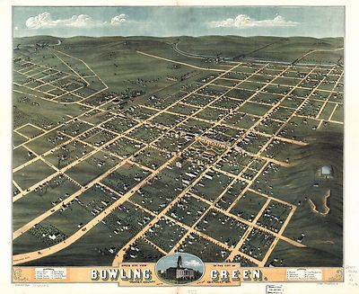
pm002330
|
Ruger, A.
Main Title: Bird’s eye view of the city of Bowling Green, Warren County,
Kentucky 1871. Drawn by A. Ruger.
Published/Created: [Chicago] Chicago Lithographing Co. [1871]
|

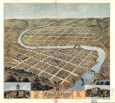
pm002340
|
Ruger, A.
Main Title: Bird’s eye view of the city of Frankfort, the capital of
Kentucky 1871.
Published/Created: Cincinnati, Ehrgott & Krebs Lith. [1871]
|

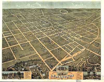
pm002350
|
Ruger, A.
Main Title: Bird’s eye view of the city of Lexington, Fayette County,
Kentucky 1871.
Published/Created: Cincinnati, Ehrgott & Krebs Lith. [1871]
|

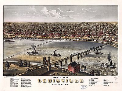
pm002360
|
Ruger, A.
Main Title: Bird’s eye view of Louisville, Kentucky 1876. [By] A. Ruger.
Chas. Shober & Co., props. Chicago Lith. Co.
Published/Created: [Chicago, 1876]
|

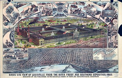
pm002370
|
Clarke, William F.
Main Title: Birds-eye view of Louisville from the river front and Southern
Exposition, 1883. W. F. Clarke.
Published/Created: Cin[cinna]ti, M.P. Levyeau & Co. [1883]
|

pm002380
|
Postlethwaite, J. Blanton.
Main Title: Bird’s eye view of Paducah, Kentucky 1889. Drawn by J. Blanton,
Postlethwaite.
Published/Created: Cincinnati, Krebs Lith. Co., 1889.
|

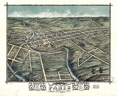
pm002390
|
Ruger, A.
Main Title: Bird’s eye view of the city of Paris, Bourbon County, Kentucky
1870.
Published/Created: [n.p., 1870]
|

rr000020
|
Lay, Amos, 1765-1851.
Main Title: Map of the United States compiled from the latest and most accurate
surveys by Amos Lay, geographer & map publisher, New York.
Published/Created: London, 1834.
|

rr002240
|
Burr, David H., 1803-1875.
Main Title: Map of Kentucky & Tennessee exhitibing the post offices,
post roads, canals, rail roads, &c.; by David. H. Burr (Late topographer
to the Post Office,) Geographer to the House of Representatives of the U.S.
Published/Created: [London, 1839]
|

rr002250
|
Lloyd, James T.
Main Title: Lloyd’s official map of the state of Kentucky compiled from
actual surveys and official documents, showing every rail road & rail
road station with the distances between each station. Also the counties and
county seats, cities, towns, villages, post offices, wagon roads, canals,
forts fortifications &c.
Published/Created: New York, 1863, c1862.
|

rr002260
|
Hoeing, Joseph Bernard, 1855-
Main Title: Preliminary map of Kentucky 1891. Prepared for the Kentucky railroad
commissioners by the Kentucky Geological Survey, John R. Procter, Director.
Published/Created: New York, 1889.
|

rr003450
|
Boone, Albert E.
Main Title: Boones map of the Black Diamond System of Railways, J. D. McKisson
del., Perysville Ohio.
Published/Created: [Knoxville, Tenn., 1896]
|

rr003810
|
Hinamn, Russell.
Main Title: Map of the surveys of the Cincinnati Railway, W.A. Gunn, Ch.
Eng.
Published/Created: Cincinnati, 1873.
|

rr003910
|
G.W. & C.B. Colton & Co.
Main Title: Map showing the Consolidated Southern Railway, Kentucky
Division--Eastern Kentucky R.R. Virginia Division--Norfolk & Cincinnati
R.R. Tennessee & Carolina Division and its connections.
Published/Created: New York, 1883.
|

rr004500
|
Thatcher, Edwin.
Main Title: Map of surveys for the Louisville & Cincinnati B’ch
Railroad; I. M. St. John, Chief Eng’, 1866.
Published/Created: Louisville, Ky., 1866.
|

rr004740
|
McBean, William.
Main Title: A map of a part of the southern & western states showing
the contemplated route of the New Orleans & Ohio Railroad and the Central
Railroad of Illinois, also the route of the Mobile & Ohio Railroad
representing the most central, direct and practicable route for a great national
and commercial highway between the Gulf of Mexico and the Great Northern
Lakes, and by various branches and intersections with other Railways connecting
with all the principal cities of the United States.
Published/Created: New Orleans, 1850.
|

rr005460
|
G.W. & C.B. Colton & Co.
Main Title: Map of the Richmond and Louisville R.R. connecting the railroads
of Virginia with the railroads of Kentucky on the shortest route east and
west of the Mississippi Valley to the Atlantic Ocean.
Published/Created: New York, 1882.
|

rr006030
|
G.W. & C.B. Colton & Co.
Main Title: Map of the Virginia, Kentucky, and Ohio Railroad connecting the
railroads of Virginia with the railroads of Kentucky on the shortest route
east and west from the Mississippi Valley to the Atlantic Ocean.
Published/Created: New York, 1881.
|

0027002
|

0073012
|

0102027
|

0151049
|

0152045
|

0152048
|

0280010
|

0285024
|

0352034
|

0358039
|

0425047
|

0425113
|

0462002
|

0535032
|

0545031
|

0572025
|

0887006
|

0890135
|

1550041
|

1550044
|

1690102
|

2054037
|

2094030
|

2134068
|

2305057
|

2307018
|

2329003
|

2468013
|

2514030
|

2589032
|

2593029
|

2680027
|

2721026
|

2782010
|

2809035
|

2809036
|

2809037
|

2809038
|

2844038
|

2844039
|

2866049
|

2915003
|

2931041
|

3145002
|

3370001
|

3389007
|

3471010
|

3565105
|

3803032
|

4323007
|

4324018
|

4328030
|

4399002
|

4416003
|

4534025
|

4557028
|

4574029
|

4578028
|

4587045
|

4587048
|

4727033
|

4786002
|

4817001
|

4825047
|

4835036
|

4862019
|

4864026
|

4866049
|

4884036
|

4912002
|

4926002
|

4977026
|

5022027
|

5028067
|

5028068
|

5041034
|

5198025
|

5230002
|

5363028
|

5371121
|

5371123
|

5479073
|

5479077
|

5745055
|

5755015
|

5784024
|

5956039
|

6323004
|

6323030
|

6323031
|

6727030
|

6921124
|
|
|