Maps of
Florida

0041011
|
Florida
Asher & Adams
1874 |

0089031
|
Florida
Bradford, Thomas G.
1838 |

0104008
|
Florida
Burr, David H
1839 |

0122032
|
Florida
Carey, H. C
1822 |

0149036
|
Florida
Colton, G.W.
1856 |

0278013
|
Florida
Finley, Anthony
1826 |

0285031
|
Florida
Finley, Anthony
1831 |

0346029
|
Coast Of West Florida and Louisiana...with the Bahama Islands.
Jefferys, Thomas
1776 |

0537022
|
Florida
Mitchell, Samuel Augustus
1845 |

0565018
|
County Map Of Florida.
Mitchell, Samuel Augustus
1860 |

0586026
|
Florida, Mobile
Mitchell, Samuel Augustus
1880 |

0594027
|
Florida
Mitchell, Samuel Augustus
1890 |

0632022
|
East and West Florida
Morse, Jedidiah
1794 |

0890141
|
Florida
Society for the Diffusion of Useful Knowledge (Great Britain)
1834 |

0977018
|
Florida
Tanner, Henry S.
1836 |

1070014
|
Florida
U.S. General Land Office
1866 |

1780149
|
Florida, Gen. map XI
Julius Bien & Co.; United States. War Department
1895 |

1780150
|
Florida, Gen. map XII
Julius Bien & Co.; United States. War Department
1895 |

2209000
|
Map Of The Seat Of War In Florida
Hood, Washington
1838 |

2212268
|
Florides et Iles Lucayes
Vandermaelen, Philippe
1827 |

2239030
|
Florida, Georgia, and South Carolina
Lloyd, H. H.
1873 |

2301031
|
Florida
Morse, Sidney Edwards); Breese, Samuel
1845 |

2329007
|
Floride, Delta du Mississippi canal.
Poussin, Guillaume Tell
1834 |

2483024
|
Florida, Mobile
Mitchell, Samuel Augustus
1870 |

2665001
|
Florida And Part Of Georgia And Alabama.
Bachmann, John
1861 |

2710035
|
Florida, Georgia, and South Carolina.
Walling, H. F.; Gray, Ormando Willis
1872 |

2755018
|
Florida
Tanner, Henry S.
1825 |

2905019
|
Florida
Johnson, A.J.
1860 |

3565095
|
Florida
Rand McNally and Company
1897 |

3884013
|
Florida
Mitchell, Samuel Augustus
1831 |

4100001
|
Township map Florida
Associated Railway Land Dept of Florida
1890 |

4520035
|
Florida
Rand McNally and Company
1879 |

4584072
|
Florida
Lucas, Fielding Jr
1823 |

4628056
|
Map of the Territory of Florida
Burr, David H
1835 |

4662010
|
The Bahama Banks and Gulf of Florida. East sheet
Blunt, Edmund March
1827 |

4662011
|
The Bahama Banks and Gulf of Florida. West sheet
Blunt, Edmund March
1827 |

4662012
|
Composite: Bahama Banks, Gulf of Florida.
Blunt, Edmund March
1827 |

4723010
|
Jefferys, Thomas
The Peninsula and Gulf of Florida or Channel of Bahama with the Bahama Islands.
1775 |

4723013
|
The Island of Cuba with part of the Bahama Banks & the Martyrs.
Jefferys, Thomas
1775 |

4807152
|
Florida
Meyer, Joseph
1845 |

4850056
|
Map of the Territory of Florida.
Greenleaf, Jeremiah
1840 |

4966017
|
Florida
Hinton, John Howard
1832 |

5007003
|
Il Paese de' Selvaggi Outauacesi, e Kilistinesi Intorno al Lago Superiore.
Zatta, Antonio ; Mitchell, John
1778 |

5007013
|
Parte Orientale della Florida, della Giorgia, e Carolina Meridionale.
Zatta, Antonio ; Mitchell, John
1778 |

5190001
|
Drew's New Map Of The State Of Florida.
Drew, Columbus
1870 |

5370006
|
Florida
Cram Atlas Company
1875 |

5388024
|
Florida
Tanner, Henry S.
1823 |

5699015
|
West Indies 1
Arrowsmith, Aaron
1810 |

ar007501
|
Bellin, Jacques Nicolas
Carte de la Florida, de la Louisiane, et pays voisins : pour servir a`
l’Histoire ge´ne´rale des voyages / par M. B., ing. de la
marine, 1757.
1780 |

ar076300
|
Cierto, Balentin.
Descripcion de la costa de Tierra Firme desde el Rio de la Empalizada hasta
Cavo de Clara. Por las latitudes y longitudes de Dn. Bartolome de Rosa. Echo
por Balentin Cierto primer Piloto de la Real Armada, an~o de 1757.
[1757]
|

ar161200
|
Clemes, Andres.
Descripsio´n de la costa de la Luciana y entrada en el Ri´o de
Micisipi con sus zonds. y baxos, nuebamte. correjido y enmendo por los pilos.
de la Armada, el an~o 1769. Deligneado pr. el pilotin de la Rel. Arma. Dn.
Andres Clemes bajo la corrn. de Dn. Pedro Rebelles, mro. deligneador por
Su Magestad a 26. de junio de 1784.
[1784]
|

ar16220a
|
Romans, Bernard
Maps of East and West Florida. B. Romans, inv. delin. & in Ære
incidit.
1781
|

ar16220b
|
Romans, Bernard
Maps of East and West Florida. B. Romans, inv. delin. & in Ære
incidit.
1781 |

ar162600
|
Slowley, Robert.
A map with part of the Florida coast from Cape Blaise to Apalachie; with
the boundaries betwixt East & West Floridas, 160 yards across the river
call’d Apalachicola. Robt. Slowley of Hs. Ms. sloop Druid, fecit September
the 4th, 1769.
[1769]
|

ar163500
|
Roworth, Sam.
A plan of the land between Fort Mossy and St. Augustine in the province of
East Florida. Sam Roworth, dept. survr. genl.
[176-?] |

ar163700
|
Jefferys, Thomas, d. 1771.
[Plan of the town and harbour of St. Augustine.
1762 |

ar163900
|
Lo´pez de Vargas Machuca, Toma´s, 1731-1802.
Plano de la ciudad y puerto de San Agustin de la Florida.
1783 |

ar164900
|
Taitt, David.
A plan of part of the rivers Tombecbe, Alabama, Tensa, Perdido, & Scambia
in the province of West Florida; with a sketch of the boundary between the
nation of upper Creek Indians and that part of the province which is contigious
thereto, as settled at the congresses at Pensacola in the years 1765 &
1771. Collected from different surveys at the desire of the Hon¯ble
John Stuart, Esquire, sole agent and superintendant of Indian Affairs for
the southern district of North America. By David Taitt.
[1771?]
|

ar165300
|
Pansacola o Santta Mari´a de Galbe, puerto y presidio del Ry. de
Espan~a situado en la costa del nortte del Seno Mexicano, los 30 grados 25
mins. de lattd. nortte y los 286 grados y 37 ms. de longd. desde Tenerife
265 leguas inglesas o 227 espan~olas al nordestte 1/4 al nortte de la Veracruz
i 185 leguas inglesas o 162 espan~olas al nordeste 1/4 al nortte de la Havana.
[ca. 1760] |

ar165600
|
Gauld, George.
A plan of the harbour of Pensacola in West-Florida. Surveyed in the year
1764 by George Gauld, M.A. The bar by Sir John Lindsay.
[1764]
|

ar165700
|
A Plan of the town of Pensacola, 1767.
[1767] |

ar166100
|
Purcell, Joseph.
A plan of Pensacola and its environs in its present state, from an actual
survey in 1778.
|

ar166700
|
Paredes, Antonio Donato.
Plano de la bahia de Pansacola. Copiado pr. el pilotin del No. Dn. Josef
Magule bajo la correccion del Alfe´rez de frag[a]ta Dn. Pedro Rivelles,
mro. delineador por S. M. del Departam[en]to de Cadiz su original levantado
el an~o de 82, por Dn. Antonio Donato Paredes.
[1782] |

ct000068
|
White, John, fl. 1585-1593.
S. Augustini : pars est terra Florida, sub latitudine 30 grad, ora vero maritima
humilior est, lancinata et insulosa.
1589. |

ct000134
|
Le Moyne de Morgues, Jacques, d. 1588.
Floridae Americae provinciae recens & exactissima descriptio auctore`
Iacobo le Moyne cui cognomen de Morgues, qui Laudo¯nierum, altera Gallorum
in eam prouinciam nauigatione comitat est, atque adhibitis aliquot militibus
ob pericula, regionis illius interiora & maritima diligentissime` lustrauit,
& exactissime` dimensus est, obseruata etiam singulorum fluminum inter
se distantia, ut ipsemet redux Carolo .IX. Galliarum regi, demonstrauit.
[S.l. : s.n., 1591] |

ct000135
|
Matthews-Northrup Company.
"Standard guide" map of the state of Florida.
[S.l.], 1891
|

ct000138
|
United States. Army. Corps of Engineers.
Seat of War.
[S.l.], 1839. |

ct000139
|
Rand McNally and Company.
Map of West Palm Beach, Lake Worth, and Palm Beach, Florida.
[S.l.], 1907. |

ct000140
|
Bruff, Joseph Goldsborough, 1804-1889.
The State of Florida.
[S.l.], 1846 |

ct000142
|
Jacksonville, St. Augustine, and Indian River Railway.
Map of the peninsula of Florida and adjacent islands : East Coast Line, the
St. Augustine routes and connections.
[Florida] : Jacksonville, St. Augustine and Indian River Railway ; Buffalo,
N.Y. : Matthews Northrup Co. [printers], [1893] |

ct000143
|
Pleuthner, W. K.
[Panoramic view of West Palm Beach, North Palm Beach and Lake Worth].
[S.l.], 1915 |

ct000145
|
Beckwith, J. P.
The east coast of Florida is paradise regained.
[S.l.], 1898. |

ct000275
|
Rocque, Mariano de la.
Plano numero 1. de la barra, y Rio de San Juan desde su entrada hasta dos
millas mas arriba del paso de San Nicolas, manifestandose en su curso todos
los baxos, sacatales, can~os, y ys. las que comprehende, y tambien la de
la barra chica, situacion do los reductos, y colocacion de los barcos para
su defenza, y caminos que deven tomarse para la retirada los defensores /
San Agustin de la Florida, 24 deciembre de 1791 an~os, Mariano de la Rocque.
1791. |

ct000289
|
[Map showing portion of the Caribbean Sea from Florida Keys to Nicaragua].
[17--?] |

ct000499
|
Geological Survey (U.S.)
State of Florida; base map / Compiled in 1932.
Washington, 1940. |

ct000607
|
Spain. Dericcio´n de Hidrografi´a
Bahia de Tampa
Madrid, Dericcio´n de Hidrografi´a 1809 |

ct000626
|
Vinckeboons, Joan.
[Map of the Peninsula of Florida].
[1639?]
|

ct000672
|
Lafon, Barthe´le´my, 1769-1820.
Carte ge´ne´rale du territoire d’Orle´ans comprenant
aussi la Floride Occidentale et une portion du territoire du Mississipi /
drese´e d’apre`s les observations les plus re´centes par Bmi.
Lafon, inge´nieur ge´ographe a` la N[ouve]lle. Orle´ans.
Paris : Ch. Picquet, 1806.
|

ct000730
|
De Brahm, John Gerar William, 1717-ca. 1799.
[Charts of the coast of Florida] By W. de Brahm.
[1765]
|

ct000731
|
Vignoles, Charles Blacker, 1793-1875.
Map of Florida.
[S.l.], 1823.
|

ct000732
|
Searcy, I. G.
Map of Florida : constructed principally from authentic documents in the
land office at Tallahassee / by I.G. Searcy.
Tallahassee : I.G. Searcy and F. Lucas, Jr., 1829.
|

ct000882
|
Hackley, Richard S.
Map of the lands belonging to R.S. Hackley, esq., in east Florida / R.S.
Hackley.
[1823?]
|

ct001038r
|
Ortelius, Abraham, 1527-1598.
Peruuiae avriferæ regionis typus / Didaco Mendezio auctore. La Florida
/ auctore Hieron. Chiaues. Guastecan reg.
[S.l. : s.n., 1584]
|

ct001123
|
Crisp, Edw. (Edward)
A compleat description of the province of Carolina in 3 parts : 1st, the
improved part from the surveys of Maurice Mathews & Mr. John Love : 2ly,
the west part by Capt. Tho. Nairn : 3ly, a chart of the coast from Virginia
to Cape Florida / published by Edw. Crisp ; engraved by John Harris.
[London] : Edw. Crisp, [1711?]
|

cw0017750
|
United States Coast Survey.
Preliminary chart of the northeastern part of the Gulf of Mexico, including
the Strait of Florida. Autographic transfer 1861.
[Washington, U.S. Coast Survey, 1861]
|

cw0102800
|
Hains, Peter C. (Peter Conover), 1840-1921.
Military map no. 54, prepared as basis for additional surveys prepared under
direction of Capt. P. C. Hains, U.S.A., Act. Chief, Engineer Dept. of the
Gulf. Drawn for stone by Helmuth Holtz.
[S.l.], Printed by W. Pro[bert, 1864?]
|

cw0117300
|
Lindenkohl, H. (Henry)
Northern part of Florida Drawn by H. Lindenkohl. Compiled and published at
the United States Coast Survey Office, A. D. Bache, Superintendent. 1864.
[S.l.], United States Coast Survey Office, 1864.
|

cw0117350
|
United States Coast Survey.
Cedar Keys, Florida From a trigonometrical survey under the direction of
A. D. Bache, Superintendent of the survey of the coast of the United States.
Triangulation by F. H. Gerdes, Asst. and B. Huger Jr., Sub-Assist. Topography
by F. H. Gerdes, Asst. Hydrography by the parties under the command of Lieuts.
Comdg. O. H. Berryman & J. J. Guthrie, U.S.N. Assts. Redd. drng by A.
Schoepf and A. Strauss [sic]. engd. by W. Langran and F. Bartle. Lith. of
C. Knickerbocker, Albany, N.Y.
[Washington, U.S. Coast Survey], 1861
|

cw0117370
|
United States Coast Survey.
Preliminary chart of main entrance to Charlotte Harbor, Florida From a
trigonometrical survey under the direction of A. D. Bache, Superintendent
of the survey of the coast of the United States. Triangulations by Lieuts.
J. C. Clark & W. R. Terrill, U.S.A. Assts. Topography by F. W. Dorr,
C. Fergunson & C. T. Jardella, Sub-Assts. Hydrography by the party of
E. Cordell, Acting asst.
[Washington, U.S. Coast Survey], 1863.
|

cw0117400
|
United States Coast Survey.
Preliminary chart of Escambia and Santa Maria de Galvaez [i.e., East] Bays,
Florida From a trigonometrical survey under the direction of A. D. Bache,
Superintendent of the survey of the coast of the United States. Triangulation
and topography by F. H. Gerdes, Asst. Hydrography by the party under the
command of Lieut. Comdg. T. S. Phelps. U.S.N. Assist.
[Washington, U.S. Coast Survey], 1861.
|

cw0117500
|
[Map of Fernandina region, Florida]
[186-?]
|

cw0117520
|
United States Coast Survey.
Preliminary chart of western end of Florida Reefs including Tortugas Keys.
[Washington, U.S. Coast Survey], 1864.
|

cw0117540
|
United States Coast Survey.
Preliminary coast chart ... Florida Reefs [on four sheets] From a trigonometrical
survey under the direction of A. D. Bache, Superintendent of the survey of
the coast of the United States.
[Washington, U.S. Coast Survey, 1864]
|

cw0117560
|
United States Coast Survey.
Preliminary coast chart ... Florida Reefs [on four sheets] From a trigonometrical
survey under the direction of A. D. Bache, Superintendent of the survey of
the coast of the United States.
[Washington, U.S. Coast Survey, 1864]
|

cw0117580
|
United States Coast Survey.
Preliminary coast chart ... Florida Reefs [on four sheets] From a trigonometrical
survey under the direction of A. D. Bache, Superintendent of the survey of
the coast of the United States.
[Washington, U.S. Coast Survey, 1864]
|

cw0117600
|
United States Coast Survey.
Sketch showing the positions of the beacons on the Florida reefs erected
by Lieut. James Totten, U.S. Army, Assistant, U.S.C.S.
[Washington, U.S. Coast Survey, 1861]
|

cw0117700
|
United States Coast Survey.
Key West harbor and its approaches. From a trigonometrical survey under the
direction of A. D. Bache, Superintendent of the survey of the coast of the
United States. Triangulation by J. E. Hilgard, Assistant. Topography by L.
H. Adams, Sub-Asst. Hydrography by the party under the command of Lieut.
John Rodgers, U.S. Navy Assistant. Redd. drng. by E. K. Knorr. Engd. by E.
Yeager, E. F. Woodward, and H. M. Knight. Published 1855.
[Washington, U.S. Coast Survey], 1864.
|

cw0119000
|
Weiss, Jacob.
A correct map of Pensacola Bay showing topography of the coast, Fort Pickens,
U.S. Navy Yard, and all other fortifications from the latest Government surveys.
J. Weiss lith.
Philadelphia, Jacob Weiss, [186-]
|

cw0120000
|
Williams, W. A.
Sketch of Pensacola Navy Yard and Fort Pickens from U.S. coast surveys. By
W. A. Williams, Civil Engineer.
Boston, L. Prang & Co., [186-]
|

cw0120300
|
United States Coast Survey.
Preliminary chart of St. Augustine harbor, Florida Triangulation by B. Huger,
Jr., Sub-Assist. Topography by F. W. Dorr, Sub-Assist. Hydrography by the
party under the command of Lieut. Comdg. A. Murray, U.S.N. Assist. Redd.
drng. by F. Fairfax & S. B. Linton. Engd. by E. H. Sipe & J. G. Thompson.
Lith. of Bowen & Co., Philada.
[Washington, U.S. Coast Survey], 1862.
|

cw0120500
|
United States Coast Survey.
St. Mary’s River and Fernandina harbor, Florida From a trigonometrical
survey under the direction of A. D. Bache, Superintendent of the survey of
the coast of the United States. Triangulation by Capt. J. H. Simpson and
Lieutenant A. W. Evans, U.S.A. Assistants. Topography by A. M. Harrison,
Assistant. Hydrography by the party under the command of Lieut. S. D. Trenchard,
U.S.N. Assist. 1857. Resurvey of bar by C. O. Boutelle, Asst. in 1862. Redd.
drng. by P. Witzel. Engd. by A. Maedel and R. F. Bartle. Bowen & Co.
lith., Philada.
[Washington, U.S. Coast Survey, 1862]
|

cw0129700
|
Map of the cost [sic] of Georgia & Florida.
[1863?]
|

cw0209000
|
Smith, Jim (Jim C.)
Charts of Savannah River, Pensacola Bay, and Key West. Showing the positions
of the several fortifications. From the United States Coast Survey From the
United States Coast Survey.
New York, c1861
|

lh000082
|
Vinckeboons, Joan.
[Map of the Gulf Coast from Florida to Mexico].
[1639?]
|

lh000870
|
Lajonk, Jaime.
Descripcion de la Bahia de Santa Maria de Galve, y Puerto de Sn. Miguel de
Panzacola con toda la costa contigua y las demas bahias que tiene en ella,
hasta el Rio de Apalache / observada, y reconozida por los ingenieros Dn.
Jaime Lajonk, y Don Juan de Siscara.
1700.
|

pm001115
|
Stoner, J. J.
Bird’s eye view of Cedar-Key, Fla., Levy Co. Beck & Pauli, litho.
Madison, Wis., 1884
|

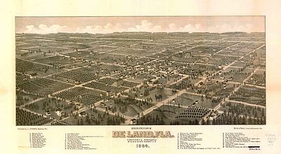
pm001118
|
Wellge, H. (Henry)
Bird’s eye view of De Land, Fla., Volusia County, 1884 / H. Wellge,
Milwaukee ; Beck & Pauli, lith., Milwaukee, Wis.
Madison, Wis. : J.J. Stoner, [1884]
|

pm001120
|
Norris, Wellge & Co.
Green Cove Springs, county seat of Clay County, Florida. 1885. Beck &
Pauli, litho.
Milwaukee, c1885
|

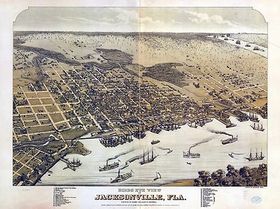
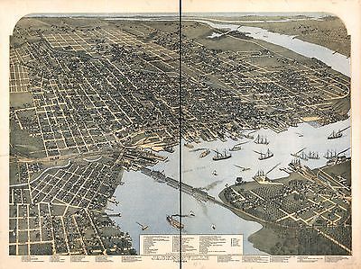
pm001130
|
Koch, Augustus, b. 1840.
Birds eye view of Jacksonville, Fla.
[n.p.] Alvord, Kellog & Campbell, 1876.
|

pm0011300
|
Koch, Augustus, b. 1840.
Birds eye view of Jacksonville, Fla.
[n.p.] Alvord, Kellog & Campbell, 1876.
|

pm001140
|
Koch, Augustus, b. 1840.
Jacksonville, Florida. Drawn, published and copyrighted by August Koch.
K[ansas] C[ity] Mo., Hudson-Kimberly Pub. Co., 1893.
|

pm001142
|
Stoner, J. J.
Bird’s eye view of Key West, Fla., Key West Island, C.S. Monroe Co.,
1884 / Wellge del.
Madison, Wis. : J.J. Stoner, [1884] (Milwaukee : Beck & Pauli, litho.)
|

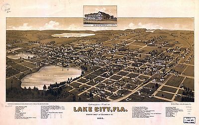
pm001150
|
Norris, Wellge & Co.
Panoramic-view of Lake City, Fla. county seat of Columbia Cty. 1885. Beck
& Pauli, litho.
Milwaukee, 1885.
|

pm001160
|
Miller, G. A.
Bird’s eye view of Longwood, Florida, Orange County 1885. G. A. Miller,
del. Forbes Co. Photo-lith.
[n.p.] P.A. Demens & Co. [1885]
|

pm001170
|
Wellge, H. (Henry)
Pensacola, Fla. county seat of Escambia County 1885. H. Wellge, del. Beck
& Pauli, litho.
Milwaukee, Norris, Wellge, & Co., c1885.
|

pm001180
|
Wellge, H. (Henry)
View of the city of Tallahassee. State capital of Florida, county seat of
Leon county 1885. H. Wellge, del. Beck & Pauli, litho.
Milwaukee, Norris, Wellge & Co., c1885.
|

pm001190
|
Wynne, James.
Aero-view of Tallahassee 1926.
[n.p., 1926]
|

pm020080
|
Green, H. H.
Bird’s-eye view of Washington, D.C.--the nation’s capital / [drawn
by] H.H. Green ; made for the B.S. Reynolds Company.
Buffalo : Matthews Northrup Works, c1916.
|

rr001930
|
Drew, Columbus.
Map of the State of Florida showing the progress of the surveys; from the
annual report of the Surveyor General for 1856.
Jacksonville, 1856.
|

rr001940
|
United States. General Land Office.
Map of the State of Florida showing the progress of the surveys accompanying
annual report of the Surveyor General for 1859.
N[ew] Y[ork], [1859]
|

rr001950
|
Drew, C[olumbus].
Drew’s new map of the state of Florida, showing the townships by the
U.S. Surveys, the completed & projected railroads, the different railroad
stations and growing railroad towns. The new towns on the rivers and interior,
and the new counties, up to the year 1874.
Jacksonville, [1874], c1873
|

rr001960
|
Elliott, D. H.
A new sectional map of Florida issued by the land department of the South
Florida R. R. Co. and the Plant Investment Co.
Sanford, Fla., 1888.
|

rr001970
|
Rand McNally and Company.
The Rand-McNally indexed county and township pocket map and shippers guide
of Florida showing all railroads, cities, towns, villages, post offices,
lakes, rivers, etc.
Chicago, 1900.
|

rr003880
|
Palmer, W. R. (William R.), d. 1862.
A map of part of Alabama & Florida, showing the route of the proposed
Columbus & Pensacola Rail Road, accompanying the report of Major J. D.
Graham, U.S. Topographical Engr. Feb. 6th, 1836; drawn chiefly from the original
surveys in the Gen. Land Office at Washington by Wm. R. Palmer, U.S. Asst.
Civil Engr.
[n.p., 1836]
|

rr004070
|
Koerner, P. W. Oscar.
[Sketch map of northeastern Florida showing the Florida Railroad and proposed
connections] Jan. 1860.
[S.l.], 1860.
|

rr004080
|
G.W. & C.B. Colton & Co.
Maps showing the Florida Transit and Peninsula Rail Road and its connections.
New York, 1882.
|

rr005450
|
American Bank Note Company.
Birds-eye-view of the Richmond & Danville Railroad and the Florida Central
& Peninsular Systems and their connections.
New York, 1893.
|

vhs00202
|
|

0027004
|

0073014
|

0102037
|

0151042
|

0152041
|

0315007
|

0352030
|

0358036
|

0425021
|

0425023
|

0535029
|

0545025
|

0579028
|

0592028
|

1071003
|

1071007
|

1550037
|

1690084
|

2054031
|

2094041
|

2134073
|

2212267
|

2307021
|

2310088
|

2329008
|

2470037
|

2470038
|

2470039
|

2501015
|

2589037
|

2593034
|

2603037
|

2743005
|

2780001
|

2809044
|

2825002
|

2844035
|

2866056
|

2915004
|

3007062
|

3471014
|

3471015
|

3803025
|

3825016
|

3888028
|

3893000
|

4100A
|

4100B
|

4323009
|

4324020
|

4328023
|

4557021
|

4574026
|

4578022
|

4587041
|

4662013
|

4723009
|
4723013
|

4727036
|

4740037
|

4825040
|

4835030
|

4862024
|

4866059
|

4884037
|

4977024
|

5022032
|

5028055
|

5028057
|

5028059
|

5028060
|

5040002
|

5198028
|

5363022
|

5371127
|

5479065
|

5699017
|

5745049
|

5755012
|

5755046
|

5784027
|

5956031
|

6727023
|

6817002
|

6830086
|
|
|
|