[Part of South Carolina and Georgia] Engineer Bureau, Dec. 24th
1864. |
 |
Map of the seat of war, in South Carolina, and Georgia. 1861 |
 |
Camp McDonald; a school of Instruction for the 4th Brigade Georgia
Volunteers His excellency Governor Joseph E. Brown, Commander in Chief. Souvenir
edition, 1917. |
 |
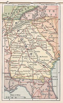
The State of Georgia, showing the major campaign areas and engagement
sites of the War between the States, 1861-1865. |
 |
Sketch of portions of seacoast of South Carolina & Georgia Drawn
by A. Lindenkohl. Autogr. copy by H. Lindenkohl. 1862 |
 |
The Virginia, Tennessee, and Georgia Air Line; the Shenandoah Valley
R.R.; Norfolk & Western R.R.; East Tennessee, Virginia, & Georgia
R.R. (its leased lines,) and their connections. 1882 |
 |
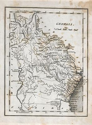
Part of northern Georgia : no. 2 / compiled under the direction of Capt.
Wm. E. Merrill, chief, Top'l Eng'r, D.C. |
 |
Map of the cost [sic] of Georgia & Florida. 1863 |
 |
Map showing the proposed Tennessee, Alabama, and Georgia Railroad connecting
and extending the Chattanooga Southern Railway, Marietta and North Georgia
Railway, Knoxville, Cumberland Gap and Louisville Railroad, and Morristown
and Cumberland Gap Railroad. |
 |
Sketch of the Atlantic coast of the United States from Savannah River
to St. Mary's River, embracing the coast of the State of Georgia Drawn by
A. Lindenkohl. 1861 |
 |
[Northern Georgia and western and central South Carolina] Drawn by A.
Lindenkohl. H. Lindenkohl & Chas. G. Krebs, lith.1865 |
 |
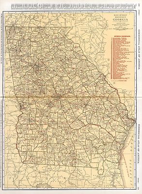
Indexed railroad and county map of Georgia. 1883 |
 |
Northwestern Georgia (with portions of the adjoining States of Tennessee
and Alabama) being part of the Department of the Cumberland. Engineer Bureau
of the War Department, January 1863. Denis Callahan, del. Lith. of J. Bien,
N.Y. |
 |
[Map of the environs of Savannah, Georgia. 186-] Drawn by A. Lindenkoh.
Chas. G. Krebs, lith. |
 |
Southern Georgia and part of South Carolina / U.S. Coast Survey, A.D.
Bache, supdt. ; drawn by A. Lindenkohl ; Chas. G. Krebs, lith. 1865 |
 |
A map of the Georgia Rail Road and the several lines of railroad connecting
with it, Febr. 1839. |
 |
The army map of Georgia. 1864 |
 |
Civil War Centennial, city of Atlanta : showing the area of the three
major engagements and deployment of Union and Confederate forces during the
summer of 1864 / prepared by State Highway Department of Georgia, Division
of Highway Planning. 1964? |
 |
A plan of the inlets & rivers of Savannah & Warsaw in the Province
of Georgia 1751 |
 |
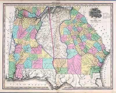
Northern Alabama and Georgia Compiled and engraved at the U.S. Coast
Survey Office, from state maps, postoffice maps, local surveys, military
reconnoissance and information furnished by the U.S. Engineers attached to
the Military Division of the Miss. Drawn by A. Lindenkohl. 1864? |
 |
Prison at Andersonville, Ga. 1864 |
 |
Northern part of Florida and Southern Georgia Drawn by H. Lindenkohl.
Compiled and published at the United States Coast Survey Office, A. D. Bache,
Superintendent. 1864. |
 |
Middle Georgia & South Carolina / U.S. Coast Survey, A. D. Bache,
supt. ; drawn by A. Lindenkohl ; Chas. G. Krebs, lith. 1865? |
 |
Map of the country embracing the various routes surveyed for the Western
& Atlantic Rail Road of Georgia, under the direction of Lieut. Col. S.
H. Long, Chief Engineer, 1837, U.S. Topographical Bureau M. H. Stansbury,
Del. Page 1 Page 2 |

 |
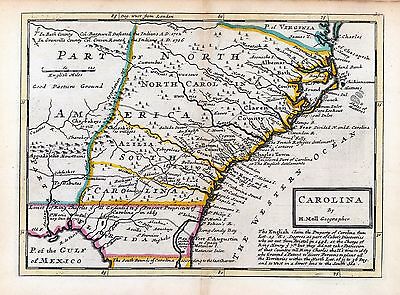
A new & accurate map of the provinces of North & South Carolina,
Georgia &c. Drawn from late surveys and regulated by astronl. observatns.
By Eman. Bowen. 1752 |
 |
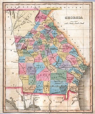
Lloyd's topographical map of Georgia from state surveys before the war
showing railways, stations, villages, mills, &c. 1864 |
 |
Birds eye view of Ocilla, Georgia 1908. Drawn and published by T. M.
Fowler. |
 |
Bird's eye view of Fitzgerald, Georgia 1908. Drawn and published by
T. M. Fowler. |
 |
Birds-eye map of the Western and Atlantic R.R., the great Kennesaw route;
Army operations, Atlanta campaign, 1864. |
 |
Genl. Sherman's campaign war map. 1864. |
 |
Sketch of a part of the coast of Georgia from Savannah River to Ossabaw
Sound showing the relative positions of the U.S. Iron clad steamer Montauk
& the rebel Fort McAllister during the bombardment of Feb 1st 1863. Prepared
under direction of Admiral S. F. Du Pont, by C. O. Boutelle, Assistant, Coast
Survey. |
 |
Birds eye view of the city of Atlanta, the capitol of Georgia 1871.
Drawn & published by A. Ruger. |
 |
Bird's eye view of Atlanta, Fulton Co., State capital, Georgia. Drawn
by Aug. Koch. Hughes Litho. Co. 1892 |
 |
Atlanta. c1919 |
 |
Birds eye view Cordele, Georgia 1908. Drawn by A. E. Downs. |
 |
Map showing the operations of the national forces under the command
of Maj. Gen. W. T. Sherman during the campaign resulting in the capture of
Atlanta, Georgia, Sept. 1, 1864 / drawn by E. Hergesheimer ; Chas. G. Krebs,
lith. |
 |
Ft. McAllister. Carried by assault on the 13th of Dec. [1864] by the
Second Division, 15th A.C., commanded by Brig. Gen. W. B. Hazon. |
 |
Map of Rome, Adairsville and vicinity Prepared for a presented with
compliments of Western and Atlantic R. R. Co. 1864 |
 |
[Map of the environs of Pine Mountain, Lost Mountain, Kenesaw Mountain,
and Little Kenesaw Mountain] G. H. Blakeslee T. E. [June 2-22, 1864] |
 |
Beaufort Harbor and coast line between Charleston, S.C. and Savanna
[sic] Ga., with 5 mile distance lines in circles round Beaufort, and R.R.
connections, roads, &c, &c. |
 |
Charts of Savannah River, Pensacola Bay, and Key West. Showing the positions
of the several fortifications. From the United States Coast Survey From the
United States Coast Survey. |
 |
Bird's eye view of Macon, Ga. c1912 |
 |
A view of Savannah as it stood the 29th of March 1734. 1876 |
 |
Preliminary chart of Wassaw Sound, Wilmington and Tybee Rivers, Georgia
From a trigonometrical survey under the direction of A. D. Bache, Superintendent
of the survey of the coast of the United States. Triangulation by C. O. Boutelle,
C. P. Bolles, A. W. Longfellow and Lieut. A. W. Evans, U.S.A. Assists. Topography
by W. H. Dennis and C. Fendall, Sub-Assists. Hydrography by the parties under
the direction of C. O. Boutelle, W. S. Edwards, Assists. and C. Fendall,
Sub-Assist. 1864 |
 |
Panoramic view of Valdosta, Ga., county-seat of Lowndes-County. Beck
& Pauli, litho. 1885 |
 |
1892 Tallapoosa, Ga. Haralson Co. Drawn & published by Geo. E. Norris.
Burleigh, lith. co. |
 |
Panoramic view of Quitman, Ga. county-seat of Brooks-County 1885. Beck
& Pauli, lith. |
 |
View of the city of Albany, Ga. (the Artesian City) county-seat of
Dougherty-County. 1885. Beck & Pauli, litho. |
 |
Macon, Ga. county seat of Bibb County 1887. H. Wellge, sk. Beck &
Pauli Lith. Co. |
 |
A map of the British and French settlements in North America. 1755? |
 |
Savannah and its environs. 1779 |
 |
Perspective map of Columbus, Ga., county seat [of Muscogee Cou]nty,
188[6]. H. Wellge. Beck & Pauli Lith. Co. |
 |
Map of Resaca and vicinity. [1864] Prepared for and presented with
compliments of Western and Atlantic R.R. Co. |
 |
Map of Marietta and vicinity. [June 1864] Prepared for and presented
with compliments of Western and Atlantic R.R. Co. |
 |
Siège de Savannah fait par les troupes françoises aux
ordres du général d'Estaing vice-amiral de France, en 7.bre,
et 8.bre 1779. |
 |
Thomasville, Ga. county-seat of Thomas-County 1885. Famous winter resort
for northern invalids and pleasure seekers. H. Wellge, del. Beck & Pauli,
lith. |
 |
Map of Dalton and vicinity. [1864] Prepared for and presented with
compliments of Western and Atlantic R.R. Co. |
 |
Map of Atlanta and vicinity. [July 1864]. |
|
From the Etowah to Burnt-Hickory, Ga. 1864 |
 |
Map of Allatoona, New Hope Church and vicinity. Prepared for and presented
with compliments of Western and Atlantic R. R. Co. |
 |
Map illustrating the siege of Atlanta, Ga., by the U.S. forces under
command of Maj. Gen. W.T. Sherman, from the passage of Peach Tree Creek,
July 19th 1864, to the commencement of the movement upon the enemy's lines
of communication south of Atlanta, August 26, 1864 / reduced and engraved
in the Engineer Bureau, War Dept., from an original prepared under the directions
of Cap. O.M. Poe, Corps of Eng's and senr. engr. on Gen'l. Sherman's staff
; Edw. Molitor, lith. |
 |
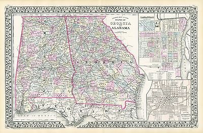
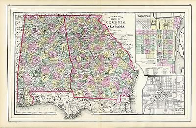
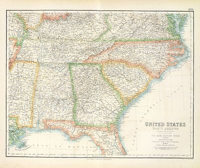
Railway and county map of the Southern States; embracing the States
of N. Carolina, S. Carolina, Georgia, Alabama, Florida, Mississippi, Louisiana,
Arkansas, and Tennessee exhibiting all the towns, villages, stations, &
landings; the rivers, railways, common roads, canals throughout these states.
Engraved by Jos. Beuther. |
 |
North America. From the French of Mr. d'Anville, improved with the back
settlements of Virginia and course of Ohio, illustrated with geographical
and historical remarks. 1758 |
 |
Carte de la Louisiane et des pays voisins dédiée à
M. Rouillé sécretaire d'État, ayant le Département
de la marine. Par le Sr. Bellin ingr. ordre. de la marine, 1750. |
 |
Atlanta campaign-1864. "Rossville" to "Snake Creek Gap." 1864 |
 |
Map of the Confederate States of America. [1861-65] Page 1
Page 2 |
 |
J. H. Colton's map of the southern states. Maryland, Delaware, Virginia,
Kentucky, Tennessee, Missouri, North Carolina, South Carolina, Georgia, Alabama,
Mississippi, Arkansas, Louisiana and Texas. Showing also part of adjoining
states & territories locating the forts & military stations of the
U. States & showing all the rail roads, r. r. stations, & other internal
improvements. 1863 |
 |
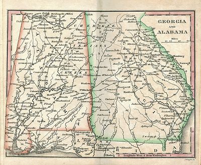
J. H. Colton's topographical map of North and South Carolina. A large
portion of Georgia & part of adjoining states. Entered according to Act
of Congress in the year 1861 by J.H. Colton. |
 |
Map showing route of marches of the army of Genl. W. T. Sherman, from
Atlanta, Ga. to Goldsboro, N.C. [1861-65] To accompany the report of operatons
from Savannah, Ga. to Goldsboro, N.C. Prepared by order of the Secretary
of War for the officers of the U.S. Army under the command of Maj. Gen. W.
T. Sherman. Engineer Bureau, War Department. |
 |
Colton's map of the southern states. Including Maryland, Delaware, Virginia,
Kentucky, Tennessee, Missouri, North Carolina, South Carolina, Georgia, Alabama,
Mississippi, Arkansas, Louisiana, Texas. Showing also part of adjoining states
& territories locating the forts & military stations of the U. States
& showing all the rail roads, r. r. stations, & other internal
improvements. 1861 |
 |
Tour route, Chickamauga Battlefield, Chickamauga and Chattanooga National
Military Park, Georgia and Tennessee. |
 |