Early Maps of Connecticut
| A correct map of Connecticut from actual survey. 1797 |
 |
| Map of the railroads of Connecticut to accompany the report ...
1893. Prepared by S. D. Tilden, Hartford. |
 |
| Connecticut, from the best authorities. 1795 |
 |
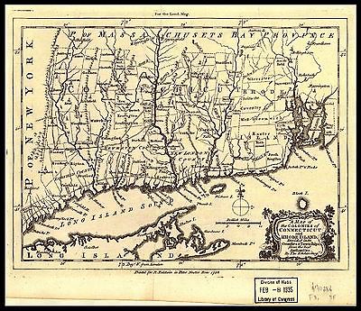
| A map of Connecticut and Rhode Island with Long Island Sound,
&c. 1776 |
 |
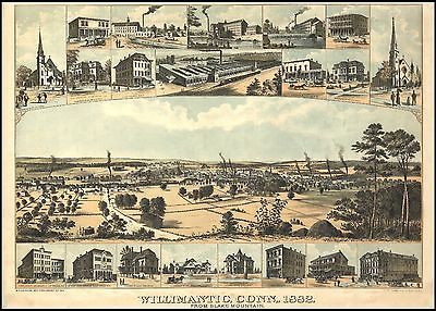
| Willimantic, Conn., 1882 From Blake Mountain |
 |
| Connecticut. 1794 |
 |
| Connecticut, from actual survey. 1813 |
 |
| A new and accurate map of Connecticut and Rhode Island, from
best authorities. 1780 |
 |
| Clark's map of Litchfield County, Connecticut. 1859 |
 |
| Connecticut. 1786 |
 |
| Map of Tolland County, Connecticut. 1857 |
 |
| Clark's map of Fairfield County, Connecticut. 1856 |
 |
| Connecticut from the best authorites. 1796 |
 |
| Smith's map of Hartford County, Connecticut. 1855 |
 |
| Map of Middlesex County, Connecticut. 1859 |
 |
| Map of the county of New Haven, Connecticut. 1852 |
 |
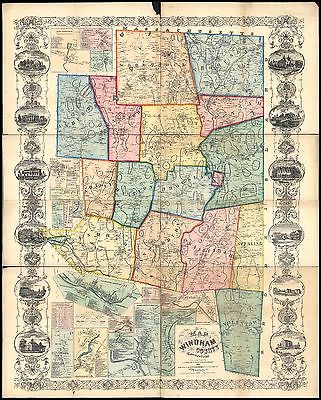
| Map of Windham County, Connecticut. 1856 |
 |
| Map of New London County, Connecticut. 1854 |
 |
| To the right honourable, the Earl of Shelbourne, His Majesty's
principal Secretary of State for the Southern Department. This plan of the
colony of Connecticut in North-America. Is humbly dedicated by his lordships
most obedient humble servt. Moses Park. Novr. 24, 1766. |
 |
| A map of the colonies in Connecticut and Rhode Island, divided
by counties & townships, from best authorities. 1758 |
 |
| Connecticut and parts adjacent. At Amsterdam by Cóvens
and Mortier and Cóvens Junior. H. Klockhoff, sculp 1780 |
 |
| Norwalk, South Norwalk, and East Norwalk, Conn. c1899 |
 |
| View of Essex, Centerbrook & Ivoryton, Conn. 1881. |
 |
| A plan of the lands in New London sequestred for the sole use
and improvement of the Mohegan Indian tribe / survey'd and measured the 7th,
8th & 9th of Septr. 1736 and protracted by the above scale of 60 pts.
to an inch by me, Humphry Avery, survr, for the county of New
London. |
 |
| Map showing the line of the Connecticut & Western Railroad
and its connections. 1871 |
 |
| A Map of 100 miles round Boston.1775 |
 |
| Map of New London and Windham counties in Conn. 1833 |
 |
| Aero view of Manchester, Connecticut 1914. |
 |
| Aero view of Ansonia, Connecticut 1921. |
 |
| Aero view of Watertown, Connecticut 1918. |
 |
| Aero view of Shelton, Connecticut 1919. |
 |
| Aero view of New London, Connecticut 1911. |
 |
| Bird's-eye view of Naugatuck, Connecticut 1906. |
 |
| Aero view of Norwich, Connecticut 1912. |
 |
| View of Higganum, Connecticut 1881. |
 |
| Bird's eye view of Wallingford, Connecticut. 1904 |
 |
| View of Cheshire, Connecticut 1882. |
 |
| View of Clinton, Connecticut 1881. |
 |
| Bird's eye view of Winsted, Connecticut 1908. By O. H.
Bailey. |
 |
| Aero view of Southington, Connecticut 1914. |
 |
| Bird's-eye-view of New Milford, Connecticut, 1906. |
 |
| Derby, Shelton, and East Derby, Conn., 1898. |
 |
| Bird's eye view of Plainville, Connecticut 1907. By O. H. Bailey.
|
 |
| Bird's eye view of Torrington, Connecticut 1907. By O. H.
Bailey. |
 |
| Aero view of Middletown, Connecticut, 1915 / T. M. Fowler,
del. |
 |
| Aero view of Willimantic, Connecticut 1909. By O. H.
Bailey. |
 |
| Aero view of Middletown, Connecticut 1915. T. M. Fowler
del. |
 |
| Plainville, Connecticut 1878. Drawn & pub. by Messrs. O.
H. Bailey & J. C. Hazen. C.H. Vogt. |
 |
| Aero view of Waterbury, Connecticut 1917. T. M. Fowler
del. |
 |
| Aero view of Meriden, Connecticut 1918. T. M. Fowler
del. |
 |
| City of Derby, Connecticut. 1920 |
 |
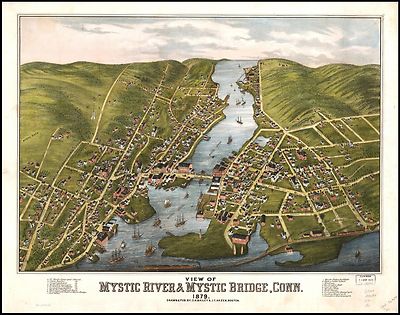
| View of Mystic River & Mystic Bridge, Conn. 1879. Drawn &
pub. by O. H. Bailey & J. C. Hazen. |
 |
| Bird's-eye view of Thompsonville (now Enfield),
Connecticut |
 |
| Map exhibiting the experimental and located lines for the New-York
and New-Haven Rail-Road. Projected and drawn by P. Anderson, civil engr.
1845 |
 |
| New Haven Harbor Founded upon a trigonometrical survey under
the direction of F. R. Hassler, Superintendent of the survey of the coast
of the United States. Triangulation by James Ferguson and Edmund Blunt,
Assistants. Topography by C. M. Eakin, W. M. Boyce & J. Farley, Assistants.
Hydrography by the party under the command of G. S. Blake, Lieut. U.S. Navy.
Final reduction for engraving by Jno. B. Gluck, Draughtsman. Engraved by
Sherman & Smith, N.Y. Electrotype copy no. 4 by S. Siebert, U.S.C.S.
1846. |
 |
| View of Madison, Conn. 1881. |
 |
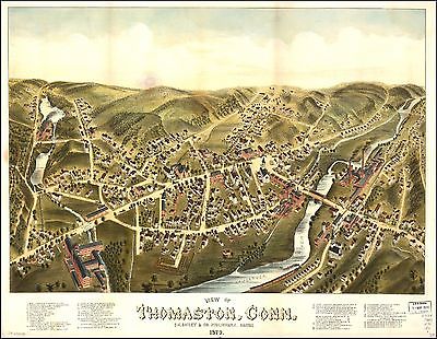
| View of Thomaston, Conn. 1879. |
 |
| Waterbury, Conn. 1899. |
 |
| Birmingham, Conn. 1876. |
 |
| View of Seymour, Conn. 1879. |
 |
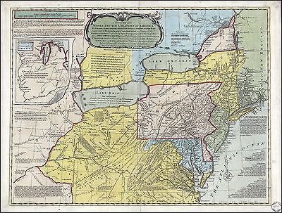
| A general map of the middle British colonies in America, viz.
Virginia, Maryland, Delaware, Pensilvania, New-Jersey, New York, Connecticut
& Rhode-Island: Of Aquanishuonigy the country of the confederate Indians
comprehending Aquanishuonigy proper, their places of residence, Ohio &
Thuchsochruntie their deer hunting countries, Couchsachrage & Skaniadarade
their beaver hunting countries, of the Lakes Erie, Ontario and Champlain.
Wherein is also shewn the antient & present seats of the Indian nations.
1771 |
 |
| Bird's eye view of Bristol, Conn. 1907. |
 |
| Colchester, May the: 6:th: Day: A.D.: 1765 |
 |
| View of Stafford Springs, Conn. 1878. |
 |
| Bristol, Conn. looking north-east. Drawn & published by Geo.
E. Norris. Burleigh Lith. Est. 1889 |
 |
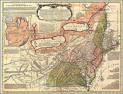
| A general map of the middle British colonies in America, viz.
Virginia, Maryland, Deleware, Pensilvania, New-Jersey, New York, Connecticut
& Rhode Island: Of Aquanishuonigy the country of the confederate Indians
comprehending Aquanishuonigy proper, their places of residence, Ohio &
Thuchsochruntie their deer hunting countries, Couchsachrage & Skaniadarade
their beaver hunting countries, of the Lakes Erie, Ontario and Champlain.
Wherein is also shewn the antient & present seats of the Indian nations.
1771 |
 |
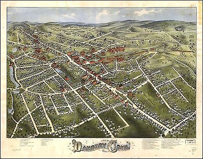
| Danbury, Conn. / published & drawn by L.R.
Burleigh. |
 |
| Middletown, Conn. 1877. |
 |
| Stamford, Conn. Drawn by L. R. Burleigh. 1883 |
 |
| View of Naugatuck, Conn. 1877. C.H.Vogt lith. |
 |
| Fort-Griswold. 1781? |
 |
| Marche de l'armée française de Providence à
la Rivière du Nord. 1781 sheet 1 |
 |
| Marche de l'armée française de Providence à
la Rivière du Nord. 1781 sheet 2 |
 |
| Marche de l'armée française de Providence à
la Rivière du Nord. 1781 sheet 3 |
 |
| View of Rockville, Conn. 1877. |
 |
| Jewett City, Conn. Drawn & published by L. R. Burleigh. Burleigh
Lith. Est. 1889 |
 |
| Wolcottville, Conn. between 1875 and 1878 |
 |
| The city of New Haven, Conn. 1879. Drawn & pub. by O. H.
Bailey & J. C. Hazen. |
 |
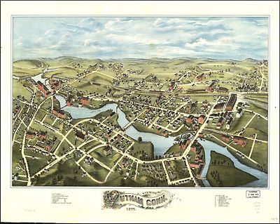
| View of Putnam, Conn. 1877. C.H. Vogt lith. Printed by J. Knauber
& Co. |
 |
| New Haven Harbor Founded upon a trigonometrical survey under
the direction of F. R. Hassler, Superintendent of the survey of the coast
of the United States. Triangulation by James Ferguson and Edmund Blunt,
Assistants. Topography by C. M. Eakin, W. M. Boyce & J. Farley, Assistants.
Hydrography by the party under the command of G. S. Blake, Lieut. U.S. Navy.
Final reduction for engraving by Jno. B. Gluck, Draughtsman. Engraved by
Sherman & Smith, N.Y. Electrotype copy no. 4 by S. Siebert, U.S.C.S.
1846. |
 |
| A general map of the middle British colonies in America, viz.
Virginia, Maryland, Delaware, Pensilvania, New-Jersey, New York, Connecticut
& Rhode-Island: of Aquanishuonigy the country of the confederate Indians
comprehending Aquanishuonigy proper, their places of residence, Ohio &
Thuchsochruntie their deer hunting countries, Couchsachrage & Skaniadarade
their beaver hunting countries, of the Lakes Erie, Ontario and Champlain.
Wherein is also shewn the antient & present seats of the Indian nations.
Carefully copied from the original published at Philadelphia, by Mr. Lewis
Evans. 1771 |
 |
| View of Windsor Locks, Conn., 1877 / O.H. Bailey & Co. Publishers
; lith. & print. by J. Knauber & Co., Milwaukee, Wis. |
 |
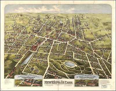
| View of New Britain, Conn. 1875. C.H. Vogt lith. J. Knauber &
Co. Print. 1875 |
 |
| View of South Manchester, Conn. 1880. |
 |
| Map of Massachusetts, Connecticut and Rhode Island; constructed
from the latest authorities. 1831 |
 |
| Colton's railroad & township map of Massachusetts, Rhode
Island, and Connecticut. 1853 |
 |
| Sketch of the states of Massachusetts, Connecticut, and Rhode
Island, and parts of New Hampshire & New York exhibiting the several
rail road routes completed, constructing, chartered & contemplated; published
by order of the Legislature of Massachusetts, 1846 |
 |
| Torrington, Conn. : 1889 / drawn & published by Geo. E. Norris,
Brockton, Mass., 1889. |
 |
| City of Norwich, Conn. 1876. C.H. Vogt, lith. Printed by J. Knauber
& Co. |
 |
| View of Danbury, Conn. 1875. Drawn by O. H. Bailey. C.H. Vogt
lith. J. Knauber & Co. printers. |
 |
| View of Unionville, Conn. 1878 |
 |
| Bowles's map of the seat of war in New England. Comprehending
the provinces of Massachusets Bay, and New Hampshire; with the colonies of
Connecticut and Rhode Island; divided into their townships; from the best
authorities. 1776 |
 |
| A new and complete county map of all the rail roads in the United
States & Canadas in operation & progress. Insert of Connecticut
1857 |
 |
| Bowles's new pocket map of the most inhabited part of New England;
comprehending the provinces of Massachusets Bay and New Hampshire; with the
colonies of Connecticut & Rhode Island; divided into their counties,
townships, &c. together with an accurate plan of the town, harbour and
environs of Boston. 178? |
 |
| Map of Maine, New Hampshire, Vermont, Massachusetts, Rhode Island,
and Connecticut exhibiting the post offices, post roads, canals, rail roads,
&c.; by David H. Burr (late topographer to the Post Office,) Geographer
to the House of Representatives of the U.S. 1839 |
 |
| J. Sage & Sons new & reliable rail road map, travellers
edition, Eastern. insert of Connecticut 1859 |
 |
| Gov. Tryon's expedition to Danbury, 1777. |
 |
| A map of the New England states, Maine, New Hampshire, Vermont,
Massachusetts, Rhode Island & Connecticut with the adjacent parts of
New York & Lower Canada; compiled and published by Nathan Hale, Boston,
1826. |
 |
| A sketch of New London & Groton with the attacks made on
Forts Trumbull & Griswold by the British troops under the command of
Brigr. Genl. Arnold, Sept. 6th. 1781. |
 |
| A new and complete railroad map of the United States compiled
from reliable sources. |
 |
| Maine, New Hampshire, Vermont, Massachusetts, Rhode Island,
Connecticut and Lower Canada, 1860. |
 |
| Nieuwe en nauwkeurige kaart van een gedeelte van Noord Amerika,
behelzende Nieuw Engeland, New York, Pensylvania, New Jersey, Connecticut,
Rhode Island, een stuk van Virginia, Kanada en Halifax, ter opheldering der
reizen van den Heer P. Kalm. C. J. de Huyser, direx., 1772. P. Mol, geletterdt.
|
 |
| A new and accurate map of part of North-America, comprehending
the provinces of New England, New York, Pensilvania, New Jersey, Connecticut,
Rhode Island & part of Virginia, Canada and Hallifax, for the illustration
of Mr. Peter Kalms travels. J. Gibson, sculp. 1771 |
 |
| Nieuwe en nauwkeurige kaart van een gedeelte van Noord Amerika,
behelzende Nieuw Engeland, New York, Pensylvania, New Jersey, Connecticut,
Rhode Island, een stuk van Virginia, Kanada en Halifax, ter opheldering der
reizen van den Heer P. Kalm. C. J. de Huyser, direx., 1772. P. Mol, geletterdt.
|
 |
| Draft of the lands disputed by Philipse Patent against Beekmans
& Rambaults.Shows area in southern Dutchess County between the Hudson
River and the Connecticut Colony line and shows designation of Fishkill Town.
1753 |
 |
| A map of the most inhabited part of New England, containing the
provinces of Massachusets Bay and New Hampshire, with the colonies of Conecticut
and Rhode Island, divided into counties and townships; the whole composed
from actual surveys and its situation adjusted by astronomical observations.
Tabula geographica cultissimam delineans Novæ Angliæ partem,
provincias nempe Massachusets Bay et New Hampshire colonias porro Connecticut
et Rhode Island in varia earum territoria divisas ex Gardineri, Kellockii,
Mitchelii, Hazzenii aliorumque geometrarum et astronomorum subsidiis per
Iohannem Michaelem Probst. Lucas Voch, ing. 1779 |
 |
| A general map of the middle British colonies in America, viz.
Virginia, Maryland, Delaware, Pensilvania, New-Jersey, New York, Connecticut
& Rhode-Island: Of Aquanishuonigy the country of the confederate Indians
comprehending Aquanishuonigy proper, their places of residence, Ohio &
Thuchsochruntie their deer hunting countries, Couchsachrage & Skaniadarade
their beaver hunting countries, of the Lakes Erie, Ontario and Champlain.
Wherein is also shewn the antient & present seats of the Indian nations.
1771 |
 |

0027008
|

0028036
|

0089013
|

0094002
|

0095002
|

0122009
|

0149022
|

0152027
|

0197012
|

0237000
|

0278004
|

0280004
|

0285012
|

0300044
|

0352019
|

0352020
|

0358024
|

0425019
|

0462001
|

0535018
|

0535019
|

0536003
|

0537010
|

0545013
|

0572015
|

0579015
|

0586013
|

0592014
|

0594013
|

0632010
|

0639002
|

0845009
|

0887002
|

0977009
|

1550024
|

1550026
|

1690056
|

2022008
|

2054021
|

2094020
|

2134056
|

2283000
|

2301008
|

2305056
|

2307015
|

2436041
|

2445002
|

2467004
|

2467017
|

2468010
|

2470010
|

2470011
|

2470012
|

2470013
|

2470014
|

2470017
|

2470018
|

2483011
|

2501005
|

2542006
|

2676000
|

2680014
|

2714002
|

2746001
|

2800002
|

2809007
|

2844012
|

2862030
|

2866038
|

2883004
|

2883010
|

2883013
|

2883016
|

2883019
|

2883022
|

2905012
|

3121002
|

3335000
|

3433002
|

3441007
|

3471008
|

3540008
|

3565072
|

3803013
|

3884004
|

3888016
|

3889001
|

3889006
|

3889007
|

3889009
|

3889010
|

3889013
|

3890001
|

3890006
|

3890007
|

3890009
|

3890010
|

3890013
|

3890B
|

4075003
|

4083002
|

4204010
|

4323004
|

4328013
|

4453014
|

4520013
|

4534015
|

4557011
|

4574014
|

4577011
|

4578010
|

4584051
|

4628038
|

4727007
|

4740029
|

4807140
|

4835016
|

4850038
|

4863030
|

4864016
|

4865007
|

4866038
|

4869003
|

4966012
|

5028022
|

5028024
|

5041011
|

5198011
|

5295001
|

5434001
|

5479036
|

5745040
|

5755005
|

5784013
|

5956015
|

6727013
|

6921120
|
|
|