Maps of
Texas

00062
|
Amerique Septentrionale
Map of the New World showing borders of France, Spain, England, Shows California
as an island.
Sanson, Nicholas
1650 |

00110
|
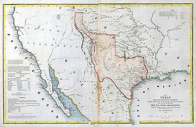
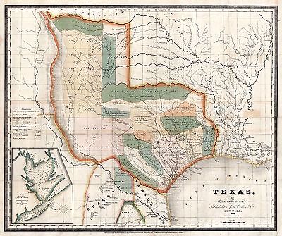
Map of Texas and the Countries Adjacent: Emory, W. H
This map accompanied the annexation treaty negotiated between the U.S. and
Texas in 1844, and was part of the accompanying documentation sent to the
Senate when the treaty was considered. For Texas to be annexed to the U.S.
by treaty, the Senate had to ratify the treaty by 2/3 votes. It did not,
and the treaty was defeated. As a result, the Texas annexation question became
a political issue in the 1844 presidential election
Compiled in the Bureau of the Corps of Topographical Engineers From the Best
Authorities, For the State Departmen
1844 |

00113
|
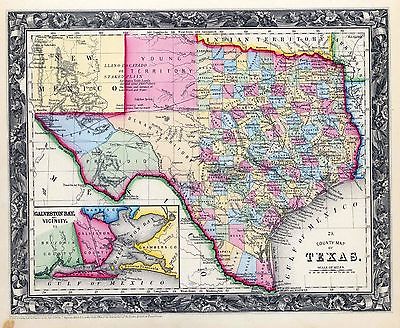
Gray's New Map of Texas and Indian Territory
Gray, Frank A
1876 |

00337
|
Mexico & Guatimala
Lizars, Daniel
1833 |

00384
|
Nueva Hispania Tabula Nova
Map of New Spain
Ruscelli, G,
1564 |

0041016
|
Texas East portion.
Asher & Adams
1874 |

0041017
|
Texas West portion.
Asher & Adams
1874 |

00574
|
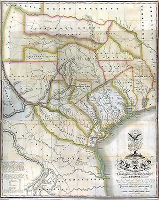
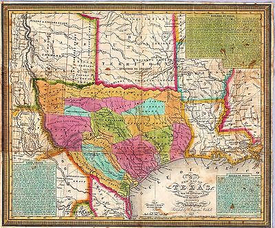
Map of The Republic of Texas
John Arrowsmith's map of Texas published in 1841 quickly became known for
its accuracy and soon became on of the most popular and influential maps
of the new republic. Perhaps the first printed map to depict Texas's claim
to the upper Rio Grande Valley, a claim which Texas maintained until the
Compromise of 1850 adjusted the boundries, the map documented the development
of towns and counties in Texas, pointing out the location of Indian tribes,
roads, and natural features
1841 |

00587
|
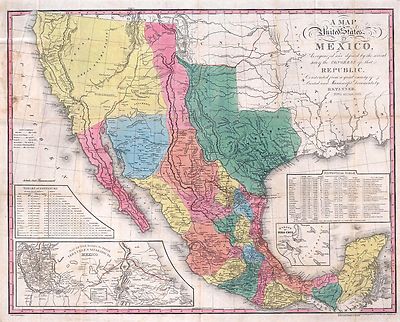
A Map of the United States of Mexico
In the first half of the 1800s, the map firm of Henry S. Tanner in Philadelphia
was perhaps the most prestigious in the U.S. In 1822, Tanner issued a map
of North America based upon the leading authorities of the day. In 1825,
he reissued the southwestern portion of this map on a larger scale and entitled
it A Map of the United States of Mexico. Especially important because the
map was published in the year the United States went to war with Mexico.
The map includes two tables: one, a table of distances between towns, and
the other, a statistical table giving basic information about Mexican states,
cities, and the produce grown in and the geography of each one.
Tanner, H. S
1846 |

00594
|
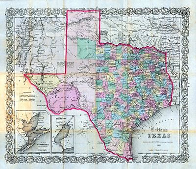
Colton's map of Texas
Colton, J. H
1861 |

00692
|
Map of Texas Shewing the Grants in Possession of the Colorado and Red
River land Compy
Marche, Konen
1835 |

00693
|
Map of Texas With Parts of the Adjoining States
Austin, Stephen
1836 |

00781
|
County Map of the State of Texas Showing also Portions of the Adjoining
States and Territories.
Gamble, W. H
1881 |

00793
|
State of Texas. Rivers of Texas, coastal waterways, mineral resources
such as silver and copper
Burr, David H
1845 |

0089038
|
Texas.
Bradford, Thomas G.
1838 |

0097001
|
A Correct Map Of The Seat Of War In Mexico.
Bruff, J. Goldsborough ; Disturnell, John
1847 |

0122033
|
Map Of Mexico.
Carey, H. C. ; Lea, I. ; Humboldt, Alexander von,
1822 |

0149041
|
Texas.
Colton, G.W.
1856 |

0197015
|
Texas, California.
Cornell, S. S. (Sarah S.)
1864 |

0262001
|
Map Of Texas And The Countries Adjacent.
Emory, William H.
1844 |

0285032
|
Mexico.
Finley, Anthony
1831 |

0534001
|
A New Map of Texas Oregon and California With The Regions Adjoining.
Mitchell, Samuel Augustus
1846 |

0537036
|
Map Of Texas.
Mitchell, Samuel Augustus
1846 |

0565020
|
County Map Of Texas.
Mitchell, Samuel Augustus
1860 |

0586029
|
Map Of Texas.
Mitchell, Samuel Augustus
1880 |

0594030
|
Texas.
Mitchell, Samuel Augustus
1890 |

0730004
|
Map of The Internal Provinces of New Spain.
Pike, Zebulon Montgomery
1810 |

0977031
|
Mexico & Guatemala
Tanner, Henry S.
1836 |

1780038
|
Galveston, Charleston Harbor, Port Hudson.
Gillmore, Quincy A.; United States. War Department
1895 |

1780054
|
Texas, pt. of N.M.
War Department
1895 |

1780065
|
Coast of Texas.
War Department
1895 |

1780161
|
Gen. map XXIII.
Julius Bien & Co.; United States. War Department
1895 |

1780162
|
Gen. map XXIV.
Julius Bien & Co.; United States. War Department
1895 |

2212260
|
Partie des Etats-Unis. Amer. Sep. 55.
Vandermaelen, Philippe
1827 |

2212266
|
Partie du Mexique. Amer. Sep. 60.
Vandermaelen, Philippe; Humboldt, Alexander von
1827 |

2239027
|
Texas.
Lloyd, H. H
1873 |

2301033
|
Texas.
Morse, Sidney E. (Sidney Edwards); Breese, Samuel
1845 |

2320001
|
Map Of The States Of Kansas And Texas And Indian Territory.
U.S. War Department
1867 |

2483027
|
Texas.
Mitchell, Samuel Augustus
1870 |

2541001
|
Mapa de los Estados Unidos De Mejico.
Disturnell, John
1847 |

2710032
|
Texas.
Walling, H. F.; Gray, Ormando Willis; Lloyd, H. H.
1872 |

2743012
|
Texas.
Lange, Henry
1854 |

2822001
|
Map Of The United States Of Mexico.
Tanner, Henry S.
1846 |

2905021
|
Texas.
Johnson, A.J.
1860 |

310014
|
Sectional Map of Texas Traversed by the Missouri, Kansas & Texas
Railway, Showing the crops adapted to each section, with the elevation and
annual rainfall.
1904 |

310104
|
Karte des Staates, Texas
map of the state of Texas drawn according to the boundaries regulated at
Washington in September 1850 and confirmed by the Texas legislature at Austin
1851 |

3254001
|
State Of Texas.
Texas and Pacific Railway
1878 |

3366001
|
J. De Cordova's Map Of The State Of Texas.
De Cordova, Jacob ; Creuzbaur, Robert ; Colton, J.H.
1856 |

3559007
|
Texas.
Mitchell, Samuel Augustus
1847 |

3565131
|
Texas.
Rand McNally and Company
1897 |

3688001
|
Map, Texas & Pacific Railway & connections.
Texas and Pacific Railway
1903 |

3713000
|
Texas And Part Of Mexico.
Bachmann, John
1861 |

3825018
|
State Of Texas.
Rogers, Henry Darwin ; Johnston, Alexander Keith
1857 |

4453040
|
Texas.
Goodrich, S.G. ; Bradford, Thomas G.
1841 |

4482001
|
Geographical Description Of The State Of Texas
Thomas, Cowperthwait & Co. ; Mitchell, Samuel Augustus
1846 |

4499001
|
Rand, McNally & Co.'s Texas.
Rand McNally and Company
1902 |

4520036
|
Texas and Indian Territory
Rand McNally and Company
1879 |

4577029
|
Mexico or New Spain.
Carey, Mathew
1814 |

4584073
|
Mexico.
Lucas, Fielding Jr
1823 |

4613044
|
Mexico.
Arrowsmith, John
1844 |

4613061
|
Map Of Texas.
Arrowsmith, John
1844 |

4656000
|
North Galveston.
1891 |

4723008
|
The Western Coast of Louisiana and the Coast of New Leon.
Jefferys, Thomas
1775 |

4749001
|
Rand McNally ... Railroad And County Map Of Texas.
Rand McNally and Company
1882 |

4764098
|
Louisiane, Cours du Mississipi.
Lisle, Guillaume de
1718 |

4801001
|
J. De Cordova's Map Of The State Of Texas
De Cordova, Jacob ; Creuzbaur, Robert ; G.W. & C.B. Colton & Co.
1867 |

4807165
|
Texas.
Radefeld, Carl Christian Franz; Meyer, Joseph
1846 |

4850064
|
Texas.
Greenleaf, Jeremiah
1840 |

5024001
|
Texas
David H Burr.
1835 |

5049001
|
State Of Texas.
Texas Land and Immigration Company
1876 |

5050001
|
Route to Texas.
A birds eye view of Texas showing the lines of the International & Great
Northern Railroad. With the stamp of Henry H. Hannan, Swan Creek, Ohio. Includes
5 drawings: Pictures of productions on the International & Great Northern
Railroad.
International & Great Northern Railroad
1878 |

5140001
|
A New Map Of Texas, With The Contiguous American & Mexican States.
Mitchell, Samuel Augustus ; Young, James H.
1836 |

5141000
|
Map of Texas and part of New Mexico.
U.S. War Department, Topographical Engineers
1857 |

5158001
|
A Map Of The United States Of Mexico
Tanner, Henry S.
1847 |

5176001
|
A Map Of The United States Of Mexico.
Tanner, Henry S.
1826 |

5178000
|
Richardson's New Map Of The State Of Texas
Richardson, W. & D. ; Desilver, Charles
1861 |

5179001
|
Texas of the United States of America.
Galveston, Houston, & Henderson Railroad
1857 |

5234001
|
Railway, steamship lines Southern Pacific Co.
Southern Pacific Company
1884 |

5237001
|
Texas and Mexico, Houston and Texas Central railways.
Houston and Texas Central Railway
1885 |

5288000
|
Large Scale County and Railroad Map Of Texas.
Rand McNally and Company
1891 |

5370023
|
Texas.
Cram Atlas Company
1875 |

5396000
|
Nouvelle Carte du Mexique, Du Texas.
Brue, Adrien Hubert
1840 |

5536001
|
Map of Mexico Showing the Seat of War
Sinclair, Thomas
1846 |

82-63
|
Map of Texas
Colton, J. H. and Co
1855 |

85-189
|
Clason’s Texas Guide Map to Texas and Northern Mexico
Clason's Texas Green Guide
1931 |

90-1681
|
Traveller's Map of the State of Texas.
Pressler, Charles W
1867 |

90-329
|
A Geographically Correct County Map of the States Traversed by the St.
Louis, Iron Mountain and Southern Railway and its Connections
Wooward, Tiernan & Hale
1882 |

91-389
|
New Map of Texas with the Contiguous American & Mexican States
Young, J. H
1836 |

95-2
|
Map of Texas and Part of New Mexico
United States Army Bureau of Topographic Engineers
1857 |

ct000005
|
Austin, Stephen F. (Stephen Fuller), 1793-1836.
Mapa topogra´fico de la provincia de Texas.
[1822?]
|

ct000006
|
Arrowsmith, John, 1790-1873.
Map of Texas / compiled from surveys recorded in the Land Office of Texas
and other official surveys by John Arrowsmith.
London : John Arrowsmith, 1841.
|

ct000090
|
Gilman, E.
Sketch of Texas with the boundaries of Mexican States as shown on General
Austin’s map of Texas published by R. S. Tanner, 1839.
1839.
|

ct000344
|
International Boundary Commission, United States & Mexico.
Boundaries between Brownsville, Texas and Matamoros, Tam. (Mexico)
[Washington, D.C. : The Norris Peters Co., 1910] |

ct000528
|
Hensoldt, E. A.
The railroad system of Texas on September 1st, 1883 / drawn for the Galveston
news by E.A. Hensoldt.
Chicago : Rand McNally & Co., engravers , 1883
|

ct000529
|
Natural provinces : [Texas].
[1899?]
|

ct000530
|
Tanner, Henry Schenck, 1786-1858.
Map of Texas with parts of the adjoining states / compiled by Stephen F.
Austin.
1837
|

ct000531
|
Blucher, Felix A.
Map of western Texas and northern Mexico from authentical surveys / made
by Felix A. Blucher, civil engineer surveyor, Nueces District ; drawn by
F.G. Baltischweiler, draughtsman, Corpus Christi, June 1st, 1868.
|

ct000532
|
Bissell’s railway junction point map of Texas / especially designed
and adapted for the computation of shortline distances in the application
of freight rates promulgated by the Railroad Commission of Texas.
[1891]
|

ct000538
|
Texas / nach den besten Quellen entw. u. gez. vom Hauptm. Radefeld.
Hildburghausen : Stich, Druck und Verlag des Bibliographischen Instituts,
[1846]
|

ct000542
|
Scho¨nberg & Co.
Scho¨nberg’s map of Texas.
[New York : Scho¨nberg & Co., 1866]
|

ct000546
|
Texas. Reclamation Dept.
Tarrant County, Trinity River, Fort Worth sheet / The state of Texas, Reclamation
Department ; topographic surveying, leveling, and mapping by Dixon B. Penick
... [et al.] ; primary traverse by R.G. Tyler, J.P. Murray, and J.B. Upchurch.
Austin : Engraved and printed by the U.S. Geological Survey, 1915.
|

ct000557
|
Colton, G. Woolworth (George Woolworth), 1827-1901.
Colton’s new map of the state of Texas : the Indian Territory and adjoining
portions of New Mexico, Louisiana, and Arkansas / compiled from the official
county maps of the General Land Office, the personal reconnaisances and
geological explorations of Prof. A.R. Roessler, the surveys of the Mexican
Boundary Commission, U.S. Coast Surveys, U.S. General Land Office, the various
Rail Road Cos., information furnished by Mr. Pressler, and other authentic
materials by G. Woolworth Colton.
New York : G.W & C.B. Colton & Co., 1872.
|

ct000558
|
Warren, Gouverneur Kemble, 1830-1882.
Map of the military dep’t of Texas : being a section of the map of the
territory of the U.S. from the Mississippi River to the Pacific Ocean / compiled
from all the reliable data by Lt. G.K. Warren, T.E., under the direction
of Capt. A.A. Humphreys, T.E. ; lith. of J. Bien.
[Washington D.C.?] : Office Expl.ns and Surveys, War Dep’t, 1859.
|

ct000559
|
O.W. Gray & Son.
Gray’s railroad map of Texas.
[S.l.], 1877-8.
|

ct000560
|
King, W. B.
Map of the city of Fort Worth and vicinity.
[S.l., 188-?]
|

ct000563
|
G.W. & C.B. Colton & Co.
Neue Karte de Staates Texas fu¨r 1881.
[S.l.], 1881.
|

ct000565
|
Northern Texas Traction Co.
[Map showing railroads and connecting lines of the Northern Texas Traction
Co. from Ft. Worth to Dallas, Texas].
[Cleveland, Ohio] : L. Wertheimer, c1905.
|

ct000566
|
Railroad map of the state of Texas / compiled and engraved expressly
for the American railroad manual.
[S.l. : s.n., 1873]
|

ct000787
|
Dallas. Public Library. Texas and Local History Dept.
Literary map of Texas. Compiled Sept. 25, 1955.
[Dallas] First National Bank in Dallas [1955]
|

ct000877
|
Standidge & Co.
Map of Texas.
[S.l., 184-?]
|

ct001066
|
United States. Topographical Bureau.
Map of Texas and the counties adjacent.
[S.l.], 1844.
|

ct001207
|
Dodge, Ira D.
Railroad map of Texas, 1926 / compiled and issued by Ira D. Dodge.
Dallas : Ira D. Dodge, 1926.
|

ct001893
|
H.H. Lloyd & Co.
County map of Texas, and Indian Territory.
Chicago, Ill. : Warner & Beers, [1875]
|

cw0446800
|
Bachmann, John.
Panorama of the seat of war : birds eye view of Texas and part of Mexico
/ drawn from nature and lith. by John Bachmann.
New York : John Bachmann, Publisher, c1861
|

la000928
|
Hamilton, Sam. R.
Map of Collin County, Texas / Sam. R. Hamilton, del. ; assisted by T. B.
Wilson, Co. Surv.
Revised to date.
St. Louis : Gast & Co., 1881.
|

la000945
|
Strong, J. M.
Official map of Dallas County, Texas / Murphy & Bolanz.
Dallas, Tex. : Murphy & Bolanz, 1886.
|

la000946
|
Street, Samuel M.
Sam Street’s map of Dallas County, Texas.
Dallas, Tex. : Sam Street, 1900.
|

la000951
|
Texas & Pacific Railway. Land Dept.
Denton County, Texas.
Marshall, Tex. : Land Dept., [187-]
|

la000952
|
Texas. General Land Office.
Map of Denton County, Texas.
St. Louis : August Gast & Co., 1879.
|

la000980
|
Texas. General Land Office.
Map of Galveston Co., Texas.
St. Louis : August Gast & Co., 1879.
|

la000981
|
Island City Abstract and Loan Co.
Map of the county and city of Galveston, Texas / compiled from original field
notes and latest surveys.
Galveston, Tex. : Island City Abstract and Loan Co., 1891
|

la000983
|
Texas. General Land Office.
Galveston Co.
Austin, Tex. : General Land Office, 1892.
|

la000984
|
Texas. General Land Office.
Gillespie County [Texas].
St. Louis : August Gast & Co., 1879.
|

la001059
|
Texas. General Land Office.
Llano County, state of Texas.
Austin, Tex. : General Land Office, 1890.
|

la001110
|
Texas. General Land Office.
Rockwall Co. [Texas].
St. Louis : August Gast & Co., 1880.
|

la001122
|
Roessler, A. R.
Map of San Saba County : exhibiting the extent of public surveys, land grants,
and other official information ; compiled from the records of the General
Land Office at Austin, showing also geology, agriculture, and mineral districts
and all important details / revised and corrected up to August 1876, A. R.
Roessler.
New York : Texas Land and Immigration Co., 1876.
|

la002010
|
Map of the county of Galveston, Texas.
Galveston, Tex. : Clarke & Courts, [1902?]
|

pm000150
|
Henry Wellge & Co.
Perspective map of, Texarkana, Texas and Arkansas. Beck & Pauli Lith.
Milwaukee [1888?]
|

pm009021
|
Fowler, T. M. (Thaddeus Mortimer), 1842-1922.
Alvord, Texas.
Morrisville, Pa., 1890.
|

pm009030
|
Motter, E. E.
Aeroplane view of business district Amarillo, Texas. Drawn by E. E. Motter.
Copyright by G. C. Sturdivant.
Amarillo, Panhandle Printing Company, c1912.
|

pm009050
|
Fowler, T. M. (Thaddeus Mortimer), 1842-1922.
Childress, Texas 1890 / drawn by T. M. Fowler.
Morrisville, Pa. : [s.n., 1890]
|

pm009060
|
Fowler, T. M. (Thaddeus Mortimer), 1842-1922.
Clarendon, Texas, Donley Co. 1890 / drawn by T. M. Fowler.
Morrisville, Pa. [1890]
|

pm009070
|
Giraud, Paul, del. & sculp.
Dallas, Texas. With the projected river and navigation improvements viewed
from above the sister city of Oak Cliff.
[Dallas?] Dallas Lith. Co., 1892.
|

pm009080
|
Norris, Wellge & Co.
Denison, Texas, Grayson County 1886. Beck & Pauli, litho.
Milwaukee [1886] c1885.
|

pm009081
|
Fowler, T. M. (Thaddeus Mortimer), 1842-1922.
Denison, Grayson County, Texas 1891. Drawn by T. M. Fowler.
Morrisville, Pa., T. M. Fowler & James B. Moyer [1891]
|

pm009100
|
Wellge, H. (Henry)
Fort Worth, Tex., "The Queen of the Prairies," county seat of Tarrant County
1886. H. Wellge, sk. Beck & Pauli, litho.
Milwaukee, Norris, Wellge & Co., 1886.
|

pm009110
|
Wellge, H. (Henry)
Perspective map of Fort Worth, Tex. 1891. H. Wellge, sk.
Milwaukee, American Publishing Co. [1891]
|

pm009130
|
Wellge, H. (Henry)
Greenville, Tex., county seat of Hunt County 1886. H. Wellge, sk. Beck &
Pauli, litho.
Milwaukee, Norris, Wellge & Co. [1886] c1885.
|

pm009140
|
Wellge, H. (Henry)
Honey Grove, Tex. Fannin County 1886. [Drawn by] H. Wellge. Beck & Pauli,
litho.
Milwaukee, Norris, Wellge & Co. [1886] c1885.
|

pm009150
|
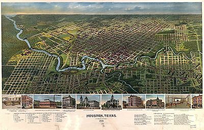
Houston, Texas ... 1891.
[n.p., 1891]
|

pm009160
|
Hopkins & Motter.
Houston--a modern city.
Houston, c1912.
|

pm009171
|
Fowler, T. M. (Thaddeus Mortimer), 1842-1922.
Ladonia, Fannin County, Texas.
Morrisville, Pa., T. M. Fowler & J. B. Moyer, 1891.
|

pm009180
|
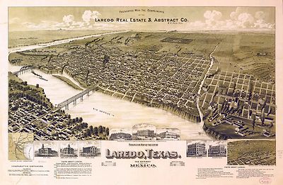
American Publishing Co. (Milwaukee, Wis.)
Perspective map of the city of Laredo, Texas, the Gateway to and from Mexico.
Presented with the compliments of the Laredo Real Estate & Abstract Co.
Milwaukee [1892?]
|

pm009200
|
Glover, E. S.
City and harbor of Port Arthur, Texas birds eye view looking south to the
Gulf of Mexico.
[Port Arthur?] Port Arthur Board of Trade, c1912.
|

pm009203
|
Fowler, T. M. (Thaddeus Mortimer), 1842-1922.
Sunset, Montague Co., Texas, 1890. Drawn by T. M. Fowler.
Morrisville, Pa., T. M. Fowler & J. B. Moyer [1890]
|

pm009210
|
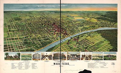
Norris, Wellge & Co.
Waco, Texas, county seat of McLennan Cy. 1886. Beck & Pauli, litho.
Milwaukee, 1886.
|

pm009220
|
Westyard, A. L.
Waco, Texas 1892.
[n.p.] D.W. Ensign & Co. [1892]
|

pm009221
|
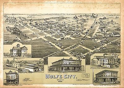
Fowler, T. M. (Thaddeus Mortimer), 1842-1922.
Wolfe City, Texas 1891. Drawn by T. M. Fowler.
Morrisville, Pa., T. M. Fowler & James B. Moyer [1891]
|

rr001710
|
Pope, John, 1822-1892.
From the Red River to the Rio Grande from explorations and surveys made under
the direction of the Hon. Jefferson Davis, Secretary of War by Captain John
Pope, Corps Topl. Engrs. assisted by Lieutenant Kenner Gerrard, 1st Dragoons,
1854-6.
[Washington, D.C., 1859]
|

rr003040
|
Rand McNally and Company.
Texas railroads.
Chicago, 1900.
|

rr003930
|
Bien, Julius, 1826-1909.
Corpus Christi and Rio Grande Railway Company, [map showing the proposed
railroad between Laredo and Corpus Christi and its connections with Mexico].
New York, [1874]
|

rr004290
|
G.W. & C.B. Colton & Co.
Map showing the Houston & Texas Central Railroad and its connections,
prepared at Colton’s Geographic Establishment, N.Y., 1867.
New York, 1867.
|

rr005510
|
Gentry, A. M.
Map of Texas showing the Sabine and Galveston Bay Rail Road, or Texas and
New Orleans Air Line Rail Line, its connections in the U.S. and adjacent
territories.
N[ew] Y[ork], 1859.
|

rr005770
|
Gentry, A. M.
Map of Texas, showing the line of the Texas and New Orleans Rail Road, and
its connections in the U.S. and adjacent territories.
[n.p.], 1860.
|

rr005780
|
G.W. & C.B. Colton & Co.
Map of the state of Texas showing the line and lands of the Texas and Pacific
Railway reserved and donated by the State of Texas, 1873.
New York, 1873.
|

0027005
|

0041015
|

0041018
|

0073017
|

0073018
|

0151047
|

0152046
|

0352033
|

0358038
|

0425115
|

0425117
|

0466072
|

0535031
|

0545039
|

0572030
|

0579031
|

0592031
|

0693037
|

0693049
|

0960102
|

1012077
|

1071007
|

1071011
|

1071012
|

1550042
|

1690096
|

1954096
|

2054035
|

2094050
|

2094051
|

2134087
|

2212259
|

2225046
|

2307022
|

2449092
|

2449093
|

2464000
|

2470045
|

2514027
|

2575000
|

2585073
|

2721034
|

2741060
|

2802001
|

2802002
|

2809049
|

2809050
|

2809052
|

2844063
|

2861022
|

2866064
|

2871035
|

2914000
|

3007060
|

3007062
|

3083044
|

3119001
|

3139001
|

3254A
|

3254B
|

3471009
|

3471013
|

3501000
|

3688A
|

3688B
|

3803029
|

3888031
|

4073001
|

4323012
|

4324023
|

4328027
|

4557025
|

4574028
|

4578036
|

4587046
|

4613061
|

4651000
|

4652000
|

4727041
|

4727042
|

4727043
|

4727044
|

4740040
|

4750002
|

4765081
|

4765092
|

4825045
|
4850064
|

4977032
|

4977034
|

4977036
|

5028121
|

5028123
|

5028124
|

5028125
|

5041032
|

5049A
|

5049B
|

5050A
|

5050B
|

5161050
|

5237A
|

5237B
|

5325000
|

5363036
|

5435000
|

5479074
|

5699013
|

5745031
|

5755031
|

5755049
|

5784030
|

6727027
|

6823002
|

6921127
|
|
|
|