Click Here. Double your traffic. Get Vendio Gallery - Now FREE!
|
FOR MANY MORE EDUCATIONAL CD TITLES
ON THIS AND MANY OTHER SUBJECTS
PLEASE VISIT OUR EBAY STORE
NO ADDITIONAL SHIPPING ON MULTIBLE CD ORDERS-ONLY $3.50 FOR ANY NUMBER OF CDs SHIPPED TO THE SAME ADDRESS IN THE US. ONLY $4.50 FOR ANY NUMBER TO ANYWHERE ELSE IN THE WORLD |
|
|
VERY LARGE HIGH RESOLUTION
MAP COLLECTION
ON CD-ROM!!
(please see full table of contents and sample illustrations below) |
|
|
This CD Contains 56 Maps of
The Polar regions
Antarctica, Artic, North Pole South Pole
These are scans of the ORIGINAL maps
on CD-ROM
System requirements
PC or Mac compatible.
Files are simple JPEG images with a basic HTML interface (just like viewing a webpage)
Works with all versions of Windows including 3.1, 95, 98, 2000 or XP. |
|
|
Features of this CD-ROM
This auction is for a CD -ROM of the maps listed in electronic form, NOT the maps themselves.
These maps are VERY high resolution and can be printed at FULL SCALE or LARGER for framing and display. The results are very high quality and convincing.
For a sample map please:
CLICK HERE
WARNING! This is a LARGE file (5 Megabytes) if you are using a slow connection it can take some time to load. |
|
|
|

0149009 |
Colton, G.W.
1856
Northern Regions.
|
|

0149010 |
Colton, G.W.
1856
Southern Regions.
|
|

0346001 |
Jefferys, Thomas
1776
Chart containing part of the Icy Sea ... Greenland ... Islands about Baffins Bay and part of Hudsons Bay.
|
|

0346005 |
Jefferys, Thomas
1776
The Russian Discoveries
|
|

0523001 |
Mitchell, Samuel Augustus
1839
World ... Equatorial Projection and Polar Projection.
|
|

1007082 |
Thomson, John
1822
Arctic Regions.
|
|

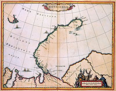
12 |
NOVA ZEMBLA
Johannes van Keulen
1680
Contemporary map users were intrigued by a map of the island in the Arctic Ocean because of the remembrance of the rigours of the arctic winter suffered by the first Dutch arctic explorer Willem Barendtsz (c. 1550-1597). During his last visit to the island in 1597 Barendtsz got stuck in the ice and, while he was unprepared, he and his crew had to stay the winter in Nova Zembla. |
|

1801002 |
Desmarest, Nicolas, 1725-1815; Bory de Saint-Vincent, M. (Jean Baptiste GeneviFve Marcellin), 1778-1846
1827
Carte des glaces boreales.
|
|

1801003 |
Desmarest, Nicolas, 1725-1815; Bory de Saint-Vincent, M. (Jean Baptiste GeneviFve Marcellin), 1778-1846
1827
Carte des glaces australes.
|
|

2113008 |
Bartholomew, J. G. (John George), 1860-1920 ; John Bartholomew and Son
1922
North Polar regions.
|
|

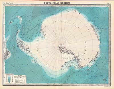
2113009 |
Bartholomew, J. G. (John George), 1860-1920 ; John Bartholomew and Son
1922
South Polar regions.
|
|

2449009 |
Stieler, Adolf
1875
Polar-Karte enthaltend: die Lander u. Meere vom Nord-Pol bis 50 degrees N
|
|

2449010 |
Stieler, Adolf
1875
Sud-Polar-Karte.
|
|

2483001 |
Mitchell, Samuel Augustus; Williams, W. (Wellington)
1870
World hemispheres.
|
|

2515002 |
Berghaus, Heinrich
1838
Die Isothermkurven Der Nordlichen Halbkugel.
|
|

2515044 |
Berghaus, Heinrich
1840
Karte Der Magnetischen Meridiane und Parallel-Kreise.
|
|

2573008 |
Woodbridge, William C.
1837
North America, Asia.
|
|

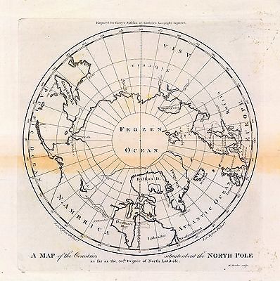
2862044 |
Carey, Mathew
1796
Map of the Countries situate about the North Pole.
|
|

3007003 |
Fullarton, A. & Co.
1872
Arctic Regions.
|
|

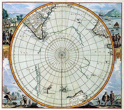
31 |
REGIONES SVB POLO ARCTICO
Joan Blaeu
1645 |
|

3362027 |
(Thomas, Joseph, publisher); Fenner, Rest.
1835
Polar Regions.
|
|

3404004 |
Hodges, William, 1744-1797; Cook, James, 1728-1779
1777
Ice Islands.
|
|

3559001 |
Mitchell, Samuel Augustus
1847
World.
|
|

3565004 |
Rand McNally and Company
1897
North Polar regions.
|
|

372 |
South Pole (late 17th century)Map in 1 hemisphere. On the map explorations in this area are marked and dated. |
|

3733069 |
Bowen, Emanuel
1747
North Pole.
|
|

4442002 |
United States Exploring Expedition (1838-1842); Wilkes, Charles, 1798-1877
1840
Chart of the Antarctic Continent.
|
|

4577057 |
Carey, Mathew
1814
North Pole countries.
|
|

4714048 |
Marzolla, Benedetto
1844
Carta generale del Polo Artico.
|
|

4714049 |
Marzolla, Benedetto
1842
Carta generale del Polo Antartica
|
|

4807008 |
Meyer, Joseph, 1796-1856
1860
Nord Pol |
|

4807009 |
Meyer, Joseph, 1796-1856
1860
Sud-Pol.
|
|

4807174 |
Radefeld, Carl Christian Franz, 1788-1874 ; Meyer, Joseph, 1796-1856
1844
Patagonia, Feuerland, Falklands, Antarctische Continent.
|
|

4850003 |
Greenleaf, Jeremiah
1840
Northern Hemisphere.
|
|

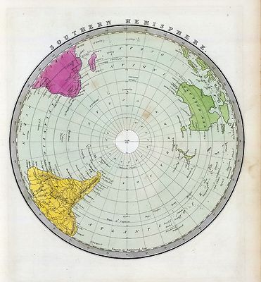
4850004 |
Greenleaf, Jeremiah
1840
Southern Hemisphere.
|
|

4863044 |
Carey, Mathew
1811
Countries situate about the North Pole.
|
|

5580002 |
Moll, Herman, d. 1732
1736
Map of the North Pole and territories near it.
|
|

5698002 |
Buache, Philippe, 1700-1773; Bouvet de Lozier, J. B. Ch., 1705-1786; Lisle, Guillaume de, 1675-1726
1754
Terres Australes.
|
|

5722000 |
Anonymous
1855
Baffin Bay journey.
|
|

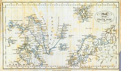
5723000 |
King, G. B.
1850
Chart, Polar Seas.
|
|

ct000176 |
General Foods Corporation.
Authorized map of the Second Byrd Antarctic Expedition.
[S.l., 1934].
|
|

ct000441 |
United States. Central Intelligence Agency.
Antarctic region.
[Washington, D.C. : Central Intelligence Agency, 1995]
|
|

ct000771 |
Edward Stanford Ltd.
The Antarctic Regions
London, England [19--]
|
|

ct000772 |
Mawson, Douglas, Sir, 1882-1958.
Route and Surveys of the South Magnetic Polar Party, 1908-09.
England : Royal Geographic Society, 1909.
|
|

ct000773 |
Wordie, J. M. (James Mann), Sir, 1889-1962
Chart to illustrate the paper on the drift of the "Endurance".
London, England, 1918
|
|

ct000774 |
Petermann, A.
[Su¨d-Polar-Karte]
[S.l.], 1912
|
|

ct000775 |
Marshall, Eric (Eric Stewart), 1879-1963.
Route and Surveys of the Southern Journey Party, 1908-09.
England : Royal Geographic Society, 1909.
|
|

ct000808 |
General Map showing the Explorations and Surverys of the Expedition, 1907-09.
England : Royal Geographic Society, 1909.
|
|

ct001473 |
Visscher, Nicolaes, 1649-1702.
Orbis terrarum nova et accuratissima tabula / auctore Nicolao Visscher.
[Amsterdam?] : Nicolao Visscher, [1690?]
|
|

ct001565 |
United States. Central Intelligence Agency.
Antarctic region.
[Washington, D.C. : Central Intelligence Agency, 2005]
|
|

ct001604 |
United States. Central Intelligence Agency.
Antarctic region.
[Washington, D.C. : Central Intelligence Agency, 2002]
|
|

ct001717 |
United States. Central Intelligence Agency.
Arctic region.
[Washington, D.C. : Central Intelligence Agency, 2002]
|
|

ct001719 |
United States. Central Intelligence Agency.
Antarctic region.
[Washington, D.C. : Central Intelligence Agency, 2000]
|
|

mf000007 |
Russia. Gidrograficheski¯i? departament. Chertezhnai?a?.
Karta Si?e?vernago Ledovitago okeana v granit?s?akh Rossi¯i?skoi? Imperi¯i : sostavlena na osnovani¯i russkikh gidrograficheskikh izsli?e?dovani¯i? s 1734 po 1871 god / sostavlena v Chertezhnoi? Gidrograficheskago departamenta Morskago ministerstva v 1872 g.; kopiroval khimicheskoi?u? tush'i?u? Timofi?e?ev.
[St. Petersburg? : s.n., 1874]
|
|

mf000026 |
Russia. Gidrograficheski¯i? departament.
Karta Ledovitago mori?a? i Vostochnago okeana / sostavlena s novi?e?i?shikh opisei? v Geograficheskom departamenti?e? Morskago ministerstva.
[St. Petersburg?] : GDMM, 1844.
|
|

mf000027 |
ssia. Depo kart.
Karta morskikh otkryti¯i? Rosi¯i?skimi moreplavateli?a?mi na Tikhom i Ledovitom mori?a?kh : v raznykh godakh uchinennykh / pri sobstvennom Ego Imperatorskago Velichestva Depo kart sochinena i po novi?e?i?shim nabli?u?deni¯i?a?m inostrannykh morekhodt?s?ov vypravlena i gravirovana 1802go goda ; soch. A. Vilbrekht.
Washington [D.C.] : Norris Peters Co., [1898]
|
|
| Thanks for bidding.
Ad and CD-ROM copyright 2004
Euriskodata, Inc.
All Rights Reserved |
The free listing tool. List your items fast and easy and manage your active items.
|