|
|
| << Back
|
GARMIN 010-C1059-00 TRAILHEAD
Condition: New
Price: $56.55

|
|
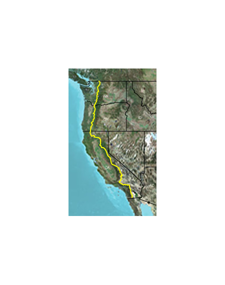
- Provides highly detailed digital topographic maps for the Pacific Crest Trail, comparable to 1:24,000 scale USGS maps.
- Contains a fully routable trail from beginning to end, plus basic road coverage available as a reference.
- Includes national, state and local parks, forests, recreational and wildlife area boundaries.
- Contains detailed hydrographic features, including coastlines, lake and river shorelines, wetlands and perennial and seasonal streams.
- Includes searchable points of interest, such as geographic place names, campgrounds, scenic lookouts and picnic sites, businesses and more.
- Displays 3-D terrain shading and digital elevation model (DEM) shaded relief on compatible devices to help estimate terrain difficulty.
- Features Bureau of Land Management township, range and section information and USGS quad locations.
- Includes coverage for the Pacific Crest Trail, plus 10 mi (16 km) of extended coverage on each side of the trail.
|
Return
Items must be returned within 14 days .
Refund will be given as Money back.
Refund policy details:
You may return a defective product up to 14 days after you receive it. NO REFUNDS WILL BE AUTHORIZED AFTER 14 DAYS. Case lots must be returned in the original shipping carton with all individual items unopened. No partial returns will be accepted. All returns require a Return Merchandise Authorization number (RMA#) which is good for 14 days. No returns will be accepted without RMA #. If you decide to return undamaged or non-defective products, you will be responsible for a 20% restocking fee.
Shipping
Destination: United States |
|---|
|
| UPS | Ground | $10.00 | | |
Payment Method
Type | Instructions to Buyer |
|---|
| Paypal | |
Insurance
Not Offered (Domestic)

|

|
|