Lake Erie Maps & Prints Ebay Store!
An Original Antique Map: Not a Reproduction!
Click For More 1682 Du Val Maps!
Free Shipping on Purchases of 5 or More Maps and Prints
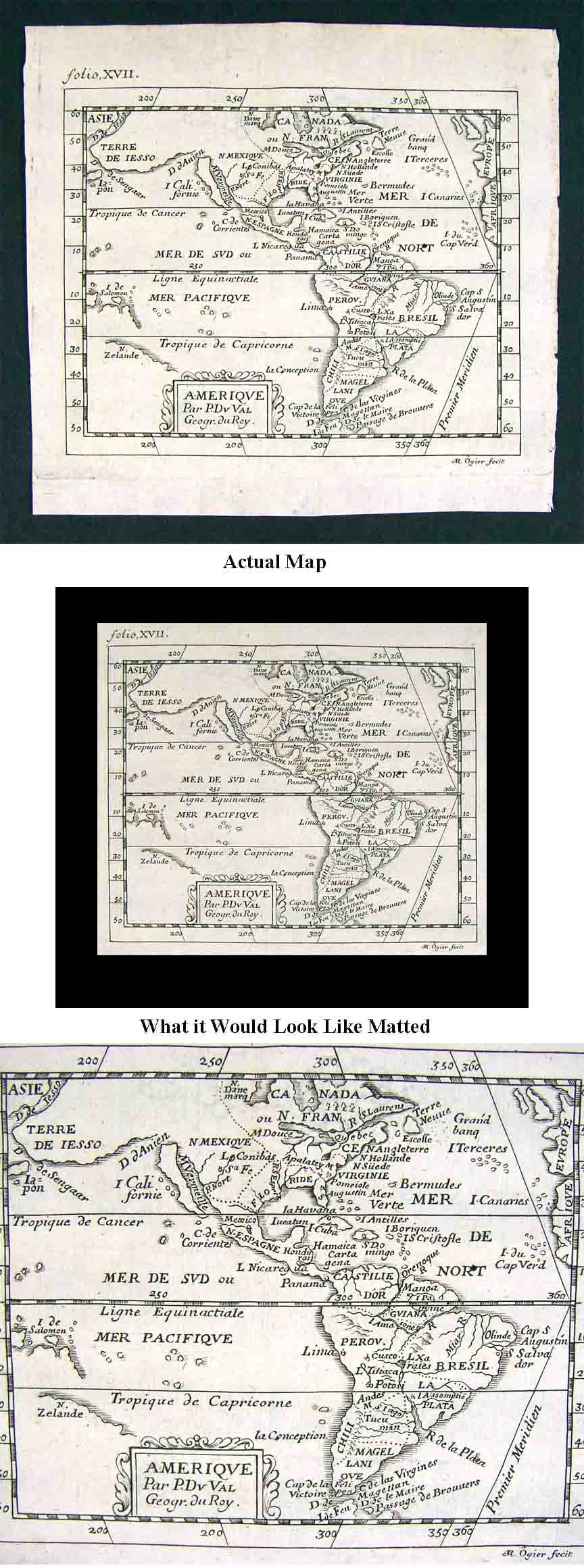
Description: It is an original copper engraved antique map with the plate mark intentions clearly seen around the margins. It is from Pierre Du Val D'Abbeville's La Geographie Universelle published in Paris, 1682. Du Val sometimes referred to as Duval (1618-1683) was the son-in-law of Nicolaes Sanson, who established the French school of cartography, with whom Du Val was an important contributor to the Sanson family business engraving Sanson's maps and later designing his own maps as printed in this atlas. In 1650 he earned the title of Royal Geographer of the King of France which he held until his death in 1683. His miniature maps are highly sought after and generally listed as scarce or rare. The map is being sold in its original uncolored state, rare to find since many of these maps have been colored in modern times. A copy of the original title page with the date is included for authenticity. It is not mounted nor matted, being sold as a single sheet as seen in the main pic. It is a very nicely preserved map for its age. A very interesting Pre Revolutionary War era map showing British Virginia and Bermuda, N. Suede or New Sweden where Delaware is today, N. Hollande in New Jersey and New York and New England above, Canada ou N. France is above, Texas as part of Florida which does show St. Augustine, Western US as Spanish New Mexico. In South America the large fictious lake in Guiana is shown, Patagonia labeled as Magellan Land, Argentina is made up of Tucuman and La Plata, a small Chili or Chile, a large Peru showing Cusco and Lima, a large Castille d'Or or Colombia and Brazil showing Olinda and Salvador and other interesting details.
Size: The map image measures approximately 4 by 5 inches on a 5 3/4 by 6 1/4" page with a wide margin all around for framing.
Condition: The map is in Very Good or better condition for its age, basically as seen in the pics. It is printed on a quality cotton page, blank on the reverse with a centerfold as issued. Other than a slight crease on the top left edge, hardly worth mentioning, the map is very clean as can be seen in the pics. Overall, very nice condition for a 17th century map. The pics are of the actual map and accurate of its condition.
Payment Details: We accept most major credit cards through Paypal. Please ask if you have any questions about payment. International Bidders are welcomed and encouraged. Payment is expected within 7 days. Nonpaying Bidders will be reported to Ebay to recoup our listing fees.
Shipping: Free Priority Mail with Delivery Confirmation in the USA or free Registered First Class International elsewhere in the world. We do our best to ship everything out fast, so if still bidding send us a quick email to hold or better just pay all at once at the end.
Multiple Purchases: We only charge one shipping fee based on the largest map or print with multiple items shipped along with it for no extra costs. Purchase 5 or more maps or prints and receive Free shipping anywhere in the world.
Satisfaction Guaranteed: We stand fully behind our products and offer a full refund minus shipping with no questions asked. If condition is different than described we offer a full refund including shipping fees.
All Prices are Firm: In order to be fair to all our customers we do not accept offers outside of ebay on auction items and will not respond to emails requesting special pricing, however we are glad to save you money on combined shipping of multiple purchases. Otherwise, feel free to ask any questions!
Check out my other items! Be sure to add me to your favorites list!
