Lake Erie Maps & Prints Ebay Store!
An Authentic Antique Map: Not a Reproduction!
See Our Ebay Store for More Antique Maps!
Free Shipping on Purchases of 5 or More Maps and Prints
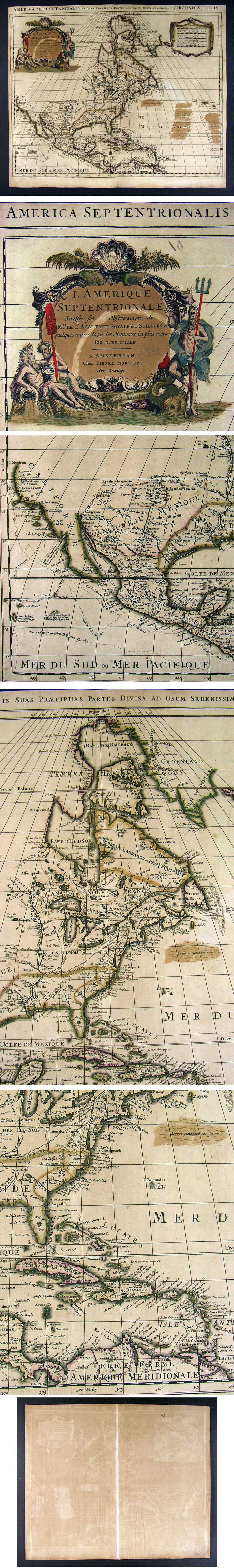
Description: It is an authentic copper engraved antique map over 300 years old. As stated in the Cartouche, it is by G. [Guillaume] De L'isle published by Pierre Mortier, Amsterdam. There is a date of c. 1703 penciled in on the Cartouche, which is erasable if desired. The date of 1703 would place it in an early edition of Covens and Mortier's Atlas Nouveau that first appeared around 1700 and continued to be republished over the next few decades. De L'isle, sometimes referred to as De Lisle or Delisle, was the royal cartographer to the King of France and the map was considered the most accurate of the time with California now being better understood as a peninsula, rather than an island, based on the accounts of Frair Eusebio Kino. As well, the Great Lakes region and the Mississippi and its tributaries were now much more accurate based on the reports of French explorers and fur traders, which De L'isle had first hand knowledge as Royal Cartographer to the King of France. The map was first presented to the Royal Academy of Sciences as stated in the cartouche, which De L'lisle was an elected member. De L'isle was especially important in the history of French mapmaking basing his maps on newer scientific and mathematical studies and measurement of latitudes and longitudes gleaning much new information from explorers and sea voyages. It is one of the first maps to depict the seaweed areas known as the Sargasso Sea in the Atlantic. Truly one of the great maps of North America. The map is being sold as seen, not matted nor framed.
Size: The map image area within the neat lines measures approximately 17 3/4 by 22 3/4 inches on a page measuring 19 1/2 by 23 1/2" with a margin all around as seen in the main pic.
Condition: The map is in Good to Very Good condition for its age with original hand color and a centerfold as issued, blank on the reverse, basically as seen in the pics. It is printed on heavy and still very flexible paper that is in great shape. The map is very clean, one minor light area off Nova Scotia, a circular mark through the cartouche as seen in the pics and a couple of insignificant pinholes seen only when held to the light. Overall the map has darkened some with age, but has a very nice desirable rich antique quality. We tried to be very accurate in matching the color of the pics to the actual map, so see the pics for more on condition. The pics are of the actual map.
Payment Details: We accept most major credit cards through Paypal and Ebay. Please ask if you have any questions about payment. International and New Bidders are welcomed and encouraged. Payment is expected within 7 days, after which Nonpaying Bidders will be reported to Ebay to recoup our listing fees.
Shipping: Free Priority Shipping in the US, elsewhere in the world add $30 for Express shipping, which is an insured and trackable service. Additional maps shipped with it for free.
International Customs and VAT Fees: It is the responsibility of the buyer to pay all Customs Taxes, VAT or other fees that may be due upon arrival. These fees vary greatly from country to country and ebay policy is that the buyer is responsible for their country's taxes and fees. Please consult your country's Customs Regulations for more details on your country, printed matter is duty free in many countries. We have to declare the full purchase value as required by law. Delays by Customs: Although most items arrive at their destination very quickly, we have no control over how long it takes an item to move through Customs, which can be held for up to six weeks in rare cases.
Satisfaction Guaranteed: We stand fully behind our products and offer a full refund minus shipping with no questions asked.
Check out my other items! Be sure to add me to your favorites list!
