Lake Erie Maps & Prints Ebay Store!
An Original Antique Map: Not a Reproduction!
Click For More 1682 Du Val Maps!
Free Shipping on Purchases of 5 or More Maps and Prints
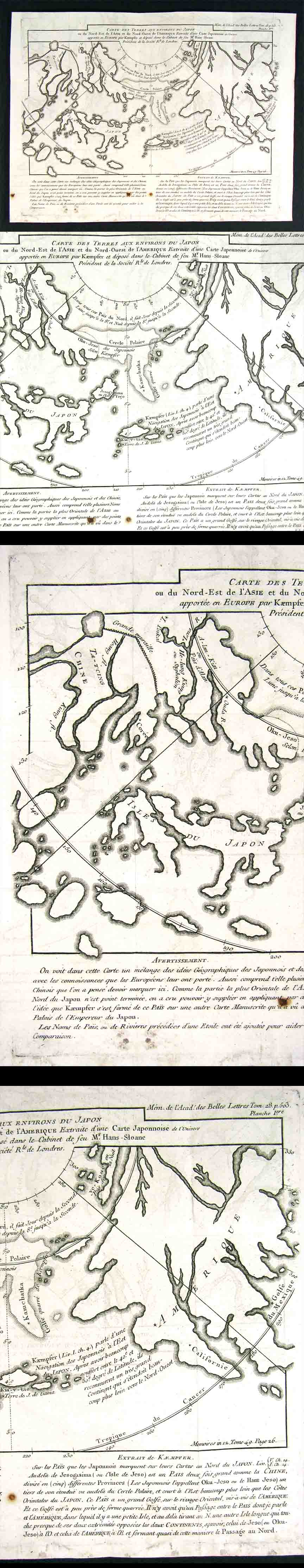
Description: It is an authentic copper engraved antique map with the plate mark intentions clearly seen around the margins. This map and another that we currently have listed separately were drawn up by Buache to illustrate his theory concerning an Asian early knowledge of North America which he presented to the French Academy of Bellas Lettres in 1752. The map has an interesting history as stated on the map, referring to the Dutch East Indies representative Engelbert Kaempfer (1651-1716) who lived in Japan for a while and gained access to the Emperor of Japan's map collection where he made a copy of the map and brought it back to Europe where the copy passed into the hands of Hans Sloane, President of the Royal Society of London, all stated in the text on the map. Kaempfter's map was redrawn by Buache for his research. He does point out in the bottom left the possibility that the Japanese map might have been based on an earlier map by Ortelius which is similar in some respects, but also states that it may have also been based on early Japanese knowledge of a large land mass referred to as Oku-Jesu or Haut Jeso. Buache supported his thesis with the supposed Chinese expedition of 458 AD. This map was then published in the French journal Memoires et Inscriptions de l'Academic des Belles Lettres, Tome 28 as stated in the margin. This Tome was published in Paris in 1861 along with text, not included. It is probably the first edition of the publishing of this map which was later published with the other related map in a combined format in Diderot's encyclopedia in the 1770s. The map is being sold as a single sheet as shown in the main pic, not matted nor framed. There are four vertical and one horizontal fold as issued and being sold in its original uncolored state. A rare nice addition to a collection. See our other listings for the companion Buache map showing the Chinese 458 AD route to America.
Size: The map image measures approximately 6 1/2 by 10 1/2 inches on a 8 1/2 by 12" (22x31cm) page with a margin all around for framing.
Condition: The map is in Very Good condition for its age, basically as seen in the pics. It is printed on a quality cotton rag page of the period with the typical striation, blank on the reverse. There is some light back printing and very light damp stains and a few rust spots along the bottom as seen in the pics. Overall, very nice condition for a mid 18th century map. The pics are of the actual map and accurate of its condition.
Payment Details: We accept most major credit cards through Paypal and Ebay services. Please ask if you have any questions about payment. International Bidders are welcomed and encouraged. Payment is expected within 7 days. Nonpaying Bidders will be reported to Ebay to recoup our listing fees.
Shipping: Free Priority Mail with Delivery Confirmation in the USA or free Registered First Class International elsewhere in the world. We do our best to ship everything out fast, so if still bidding send us a quick email to hold or better just pay all at once at the end.
Multiple Purchases: We only charge one shipping fee based on the largest map or print with multiple items shipped along with it for no extra costs. Purchase 5 or more maps or prints and receive Free shipping anywhere in the world.
Satisfaction Guaranteed: We stand fully behind our products and offer a full refund minus shipping with no questions asked. If condition is different than described we offer a full refund including shipping fees.
All Prices are Firm: In order to be fair to all our customers we do not accept offers outside of ebay on auction items and will not respond to emails requesting special pricing, however we are glad to save you money on combined shipping of multiple purchases. Otherwise, feel free to ask any questions!
Check out my other items! Be sure to add me to your favorites list!
